Файл:First Republic of Armenia in 1918-1920.png
Перейти до навігації
Перейти до пошуку

Розмір при попередньому перегляді: 799 × 348 пікселів. Інші роздільності: 320 × 139 пікселів | 640 × 279 пікселів | 1024 × 446 пікселів | 1280 × 558 пікселів | 2560 × 1115 пікселів | 8192 × 3568 пікселів.
Повна роздільність (8192 × 3568 пікселів, розмір файлу: 14,85 МБ, MIME-тип: image/png)
| Відомості про цей файл містяться на Вікісховищі — централізованому сховищі вільних файлів мультимедіа для використання у проектах Фонду Вікімедіа. |
Опис файлу
| Опис |
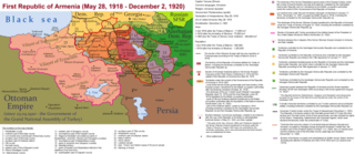
English: The First Republic of Armenia in 1918-1920. |
| Час створення | |
| Джерело | Власна робота |
| Автор | Accipite7 |
Ліцензування
Я, власник авторських прав на цей твір, добровільно публікую його на умовах такої ліцензії:
Цей файл ліцензований на умовах Creative Commons Із зазначенням автора - Розповсюдження на тих самих умовах 4.0 Міжнародна
- Ви можете вільно:
- ділитися – копіювати, поширювати і передавати твір
- модифікувати – переробляти твір
- При дотриманні таких умов:
- зазначення авторства – Ви повинні вказати авторство, надати посилання на ліцензію і вказати, чи якісь зміни було внесено до оригінального твору. Ви можете зробити це в будь-який розсудливий спосіб, але так, щоб він жодним чином не натякав на те, наче ліцензіар підтримує Вас чи Ваш спосіб використання твору.
- поширення на тих же умовах – Якщо ви змінюєте, перетворюєте або створюєте іншу похідну роботу на основі цього твору, ви можете поширювати отриманий у результаті твір тільки на умовах такої ж або сумісної ліцензії.
Історія файлу
Клацніть на дату/час, щоб переглянути, як тоді виглядав файл.
| Дата/час | Мініатюра | Розмір об'єкта | Користувач | Коментар | |
|---|---|---|---|---|---|
| поточний | 15:13, 2 червня 2021 | | 8192 × 3568 (14,85 МБ) | Accipite7 | for the convenience of viewing small details, the size is increased, the colors are improved |
| 08:17, 25 травня 2021 |  | 4096 × 1784 (3,69 МБ) | Accipite7 | The border between Nahang of Shirak and Nahang of Syunik has been clarified. | |
| 09:59, 21 травня 2021 |  | 4096 × 1784 (3,7 МБ) | Accipite7 | The temporary border between the Republic of Armenia and the Soviet republics (August 10, 1920) in the Nakhichevan county has been clarified. Added a legend marked on the map under the number 26. | |
| 08:35, 13 травня 2021 |  | 4096 × 1784 (3,97 МБ) | Accipite7 | fixed typo | |
| 08:27, 13 травня 2021 |  | 4096 × 1784 (3,97 МБ) | Accipite7 | The names of the types of administrative units of the former Russian Empire have been clarified: uyezd = county, okrug = district, oblast = territory, guberniya = governorate. | |
| 11:14, 12 травня 2021 |  | 4096 × 1784 (3,71 МБ) | Accipite7 | Corrected data in the map legend regarding what is indicated on the map by numbers. Clarified the boundaries of the territories required at the Paris Peace Conference. I strongly ask the user of Culminatio not to vandalize and not return the map to the version on which he marked the line reached as a result of the Turkish offensive in 1920. Since, firstly, it is neural: Batumi, Artvin and Ardahan were under the control of the Democratic Republic of Georgia until February-March 1921. And secon... | |
| 04:13, 12 травня 2021 |  | 5375 × 2341 (7,18 МБ) | Culminatio | Reverted to version as of 15:05, 8 May 2021 (UTC) | |
| 07:11, 11 травня 2021 |  | 4096 × 1784 (3,99 МБ) | Accipite7 | The boundaries of the territory of the demands of the Armenian delegation in the Transcaucasus, submitted to the Paris Peace Conference of 1919, were clarified. There is no need to overload the map with the line reached by the Turkish forces in 1920, as the map already shows the results of the Armenian-Turkish war of 1920 - the border according to the Treaty of Alexandropol, December 2, 1920 | |
| 15:05, 8 травня 2021 |  | 5375 × 2341 (7,18 МБ) | Culminatio | Additional line of the turkish advance on the northern positions during the war of 1920. Additional numbers 10,19,20,21 on the map. | |
| 10:49, 8 травня 2021 |  | 6336 × 2760 (2,21 МБ) | Accipite7 | Improved colors. |
Використання файлу
Така сторінка використовує цей файл:
Глобальне використання файлу
Цей файл використовують такі інші вікі:
- Використання в az.wikipedia.org
- Використання в be.wikipedia.org
- Використання в bg.wikipedia.org
- Використання в de.wikipedia.org
- Використання в el.wikipedia.org
- Використання в fi.wikipedia.org
- Використання в fr.wikipedia.org
- Використання в hy.wikipedia.org
- Використання в it.wikipedia.org
- Використання в nl.wikipedia.org
- Використання в pl.wikipedia.org
- Використання в pt.wikipedia.org
- Використання в ro.wikipedia.org
- Використання в ru.wikipedia.org
- Використання в sr.wikipedia.org
- Використання в zh.wikipedia.org