Файл:Anglosphere Map.svg

Повна роздільність (SVG-файл, номінально 2754 × 1398 пікселів, розмір файлу: 1,13 МБ)
| Відомості про цей файл містяться на Вікісховищі — централізованому сховищі вільних файлів мультимедіа для використання у проектах Фонду Вікімедіа. |
Опис файлу
| Опис |
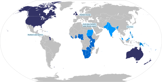
English: Map of the anglosphere.
Core Anglosphere
Middle Anglosphere
Outer sphere
Periphery |
| Час створення | |
| Джерело |
Власна робота based on File:Anglosphere Geometry.svg Per James C. Bennett's "The Anglosphere challenge", which is one of the main sources for the very concept of the Anglosphere, as described by Browning, Christopher S. and Tonra, Ben (2010) "Beyond the West and towards the Anglosphere?" In: Browning, Christopher S. and Lehti, Marko, (eds.) The struggle for the West : a divided and contested legacy. Abingdon, Oxon ; New York: Routledge, pp. 161-181. ISBN 9780415476836: https://www.academia.edu/341929/Beyond_the_West_and_Towards_the_Anglosphere "In this respect he posits the existence of a series of concentric spheres marked according tohow far each shares core Anglosphere characteristics. At the core are the central nodes of the US and Britain surrounded by English-speaking Canada, Ireland,Australia, New Zealand and the English-speaking Caribbean. The middle sphere comprises states where English is one of several official languages, but where the primary connections to the outside world are in English. This includes English-speakers in South Africa (but not Afrikaans), Zimbabwe, the non-Islamic, non-Indian former British colonies in Africa, the South Pacific, and parts of Asia. The outer sphere comprises English-using states of other civilisations and might include India, Pakistan, the Arab states formerly under British control and Britain‘s former Islamic colonies. Finally, Bennett posits a peripheral sphere of states where English is widely used but is not an official governmental language. These include Northern Europe,East Asia and northern Latin America (Bennett 2004b: 80-1). What stands out here, of course, is the omission of continental Western Europe and the implication that the cultural differences between Latin and Germanic Europe (traditionally core components of the West) and the Anglosphere are greater than those between the inner core of the Anglosphere and those of its outer and peripheral spheres." |
| Автор | DimensionalFusion |
Ліцензування
- Ви можете вільно:
- ділитися – копіювати, поширювати і передавати твір
- модифікувати – переробляти твір
- При дотриманні таких умов:
- зазначення авторства – Ви повинні вказати авторство, надати посилання на ліцензію і вказати, чи якісь зміни було внесено до оригінального твору. Ви можете зробити це в будь-який розсудливий спосіб, але так, щоб він жодним чином не натякав на те, наче ліцензіар підтримує Вас чи Ваш спосіб використання твору.
- поширення на тих же умовах – Якщо ви змінюєте, перетворюєте або створюєте іншу похідну роботу на основі цього твору, ви можете поширювати отриманий у результаті твір тільки на умовах такої ж або сумісної ліцензії.
Історія файлу
Клацніть на дату/час, щоб переглянути, як тоді виглядав файл.
| Дата/час | Мініатюра | Розмір об'єкта | Користувач | Коментар | |
|---|---|---|---|---|---|
| поточний | 18:35, 5 травня 2022 | | 2754 × 1398 (1,13 МБ) | DimensionalFusion | Updated labels for Peripheral |
| 13:45, 3 травня 2022 |  | 2754 × 1398 (1,12 МБ) | DimensionalFusion | Uploaded while editing "Anglosphere" on en.wikipedia.org |
Використання файлу
Така сторінка використовує цей файл:
Глобальне використання файлу
Цей файл використовують такі інші вікі:
- Використання в en.wikipedia.org
- Використання в fr.wiktionary.org
- Використання в id.wikipedia.org
- Використання в zh-yue.wikipedia.org