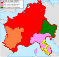
Файл:Carolingian empire 828.svg

Матеріал з Вікіпедії — вільної енциклопедії.
Перейти до навігації Перейти до пошуку

Повна роздільність(SVG-файл, номінально 1091 × 1053 пікселів, розмір файлу: 348 КБ)

Wikimedia Commons logo Відомості про цей файл містяться на Вікісховищі — централізованому сховищі вільних файлів мультимедіа для використання у проектах Фонду Вікімедіа.

Опис файлу

Опис
Español: Imperio carolingio en 828 antes de las guerras civiles.
Час створення
Джерело

Власна робота

  • [1] Sur l'epoque de la désunion de la Septimanie de Royaume de Aquitaine, & de son érection en Duché, & sur l'acte de partage que fit l'an 817, l'empereur Luis-le-Débonaire de ses Etats entre ses fils.
  • [2] Pepin continued to hold Aquitaine; but the realm sustained various alterations in boundary: only a portion of Septimania, which had hitherto been conjoined with Aquitaine, was retained by him, namely the county of Carcassonne. On the north, the frontier was also somewhat contracted, but the loss was compensated by a dismemberment of Cisjurane Burgundy, three counties -Autun, towering in Roman magnificence: smiling Nevers, and dreary Avalon, where every stone appears stamped with vestiges of once animated nature.
  • [3]: At the Aachen assembly in February 828, Louis the Pious blamed the loss of Lower Pannonia on Balderic of Friuli's "cowardice". Louis the Pious therefore revoked Balderic's honors and divided the match of Friuli into four separate counties: Carantania, Carniola, Istria, and a now greatly reduced Friuli. [...] The province of Carantania at this time passed into the control of the Bavarian king and his eastern prefect. [...] Louis could justify the annexation of Carantania on the basis of the Ordenatio imperii which explicitly included Carantania as part of his Bavarian kingdom. But as the ruler of Italy, Lothar had cotrolled Friuli (including Carantania) since 817. Balderic's downfall in 828 and the resulting Bavarian annexation of Carantania therefore represented Louis's first agressive move against his eldest brother.
  • [4]: Pippin, another son of Lewis, had dominion in Aquitaine and Gascony.
  • [5]: En 817, en Aquisgram, se hizo división entre los hijos de Luis el Piadoso: y Lotario fue asociado al Imperio; Pepino obtuvo la Gascuña y la Aquitania con los territorios de Nevers, Autun, Avallen en la Borgoña.
  • [6]: Pepin continued to hold Aquitaine; but the realm sustained various alterations in boundary : only a portion of Septimania, which had hitherto been conjoined with Aquitaine, was retained by him, namely the county of Carcassonne. On the north, the frontier was also somewhat contracted, but the loss was compensated by a dismemberment of Cisjurane Burgundy, three counties— Autun, towering in Roman magnificence : smiling Nevers, and dreary Avalon, where every stone appears stamped with vestiges of once animated nature.
Автор Trasamundo
Інші версії

Ліцензування

Я, власник авторських прав на цей твір, добровільно публікую його на умовах таких ліцензій:
GNU head Дозволяється копіювати, розповсюджувати та/або модифікувати цей документ на умовах ліцензії GNU FDL версії 1.2 або більш пізньої, виданої Фондом вільного програмного забезпечення, без незмінних розділів, без текстів, які розміщені на першій та останній обкладинці. Копія ліцензії знаходиться у розділі GNU Free Documentation License.
w:uk:Creative Commons
зазначення авторства поширення на тих же умовах
Цей файл доступний на умовах ліцензій Creative Commons Attribution-Share Alike 3.0 Unported, 2.5 Generic, 2.0 Generic та 1.0 Generic.
Ви можете вільно:
  • ділитися – копіювати, поширювати і передавати твір
  • модифікувати – переробляти твір
При дотриманні таких умов:
  • зазначення авторства – Ви повинні вказати авторство, надати посилання на ліцензію і вказати, чи якісь зміни було внесено до оригінального твору. Ви можете зробити це в будь-який розсудливий спосіб, але так, щоб він жодним чином не натякав на те, наче ліцензіар підтримує Вас чи Ваш спосіб використання твору.
  • поширення на тих же умовах – Якщо ви змінюєте, перетворюєте або створюєте іншу похідну роботу на основі цього твору, ви можете поширювати отриманий у результаті твір тільки на умовах такої ж або сумісної ліцензії.
Ви можете обрати ліцензію на ваш розсуд.

Підписи

Додайте однорядкове пояснення, що саме репрезентує цей файл

Об'єкти, показані на цьому файлі

зображує

356 703 байт

1053 піксель

1091 піксель

Історія файлу

Клацніть на дату/час, щоб переглянути, як тоді виглядав файл.

Дата/часМініатюраРозмір об'єктаКористувачКоментар
поточний12:09, 28 жовтня 2021Мініатюра для версії від 12:09, 28 жовтня 20211091 × 1053 (348 КБ)RowanwindwhistlerLighter colours, fake text added for better rendering in articles (real text is now hidden).
08:34, 4 травня 2016Мініатюра для версії від 08:34, 4 травня 20161091 × 1053 (251 КБ)RowanwindwhistlerSofter colours form http://colorbrewer2.org/
21:38, 22 квітня 2016Мініатюра для версії від 21:38, 22 квітня 20161091 × 1053 (251 КБ)RowanwindwhistlerClear shapes, some colours from https://en.wikipedia.org/wiki/Wikipedia:WikiProject_Maps/Conventions
18:30, 13 березня 2010Мініатюра для версії від 18:30, 13 березня 20101091 × 1053 (940 КБ)Trasamundolegend
18:26, 13 березня 2010Мініатюра для версії від 18:26, 13 березня 20101091 × 1053 (940 КБ)Trasamundo{{Information |Description={{es|1=Imperio carolingio en 828 antes de las guerras civiles.}} |Source={{own}} |Author=Trasamundo |Date=13 March 2010 |Permission= |other_versions= }} Category:Maps of the Carolingian Empire

Такі сторінки використовують цей файл:

Глобальне використання файлу

Цей файл використовують такі інші вікі:

Метадані