Файл:Earth's City Lights by DMSP, 1994-1995 (medium).png
Повна роздільність (2560 × 1280 пікселів, розмір файлу: 2,56 МБ, MIME-тип: image/png)
| Відомості про цей файл містяться на Вікісховищі — централізованому сховищі вільних файлів мультимедіа для використання у проектах Фонду Вікімедіа. |
Опис файлу
| Опис |
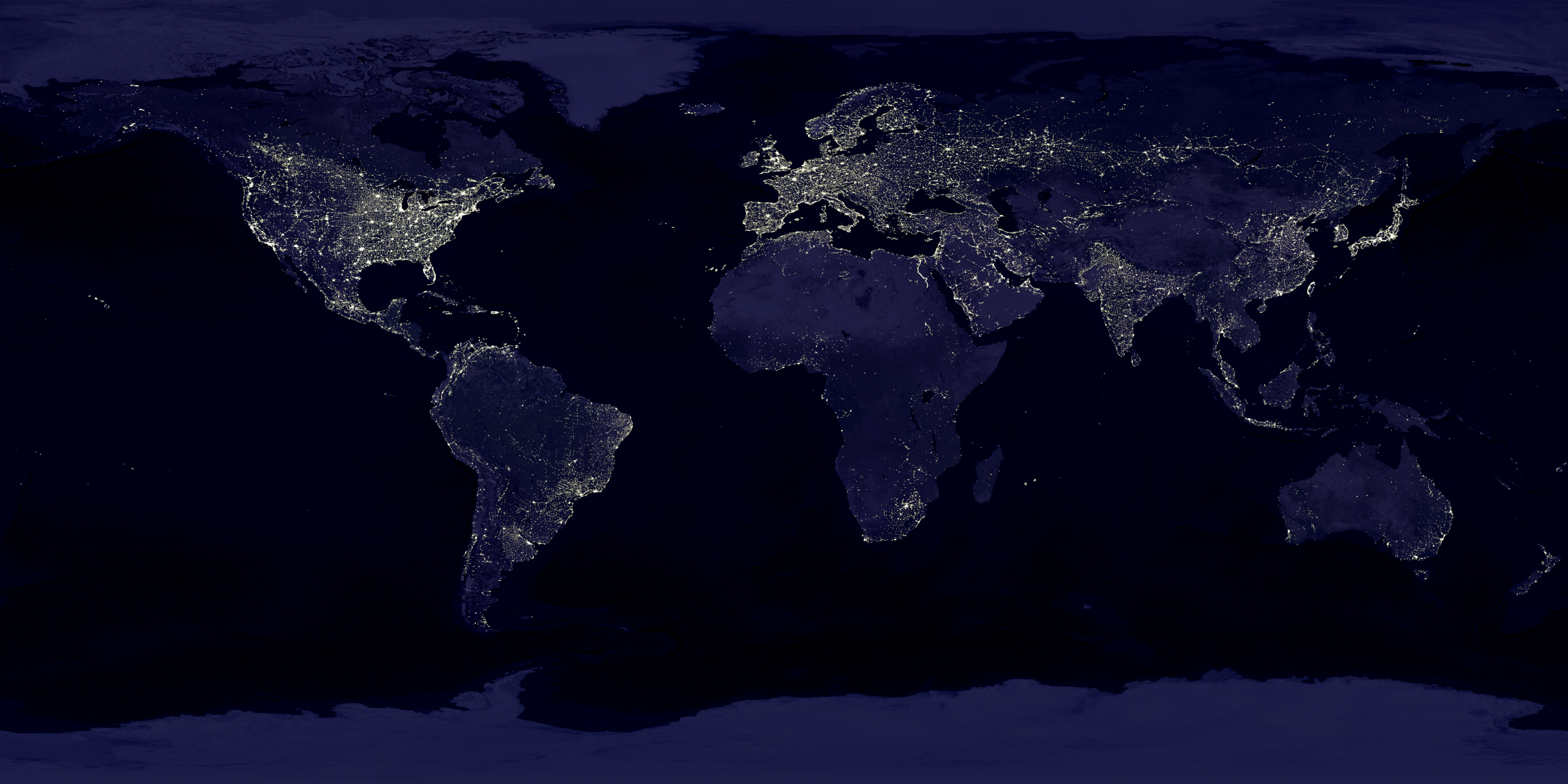
English: This image of Earth’s city lights was created with data from the Defense Meteorological Satellite Program (DMSP) Operational Linescan System (OLS). Originally designed to view clouds by moonlight, the OLS is also used to map the locations of permanent lights on the Earth’s surface.
The brightest areas of the Earth are the most urbanized, but not necessarily the most populated. (Compare western Europe with China and India.) Cities tend to grow along coastlines and transportation networks. Even without the underlying map, the outlines of many continents would still be visible. The United States interstate highway system appears as a lattice connecting the brighter dots of city centers. In Russia, the Trans-Siberian railroad is a thin line stretching from Moscow through the center of Asia to Vladivostok. The Nile River, from the Aswan Dam to the Mediterranean Sea, is another bright thread through an otherwise dark region. Even more than 100 years after the invention of the electric light, some regions remain thinly populated and unlit. Antarctica is entirely dark. The interior jungles of Africa and South America are mostly dark, but lights are beginning to appear there. Deserts in Africa, Arabia, Australia, Mongolia, and the United States are poorly lit as well (except along the coast), along with the boreal forests of Canada and Russia, and the great mountains of the Himalaya. |
| Час створення | між 1 жовтня 1994 та 31 березня 1995 |
| Джерело | https://visibleearth.nasa.gov/view.php?id=55167 (image link) |
| Автор | Data: Marc Imhoff/NASA GSFC, Christopher Elvidge/NOAA NGDC; Image: Craig Mayhew and Robert Simmon/NASA GSFC |
| Інші версії |
|
.jpg)
.jpg)
.png)

.png)
Ліцензування
| Цей файл перебуває у суспільному надбанні, оскільки він був створений NASA (Національним управлінням з аеронавтики і дослідження космічного простору). Згідно з політикою NASA стосовно авторського права, «матеріали NASA не захищаються авторським правом, якщо не вказано протилежне». (Див. Template:PD-USGov, сторінку політики NASA стосовно авторського права, або політику використання зображень JPL.) | ||
 |
Попередження:
|
This image is in the public domain because it contains materials that originally came from the U.S. National Oceanic and Atmospheric Administration, taken or made as part of an employee's official duties.
|
Історія файлу
Клацніть на дату/час, щоб переглянути, як тоді виглядав файл.
| Дата/час | Мініатюра | Розмір об'єкта | Користувач | Коментар | |
|---|---|---|---|---|---|
| поточний | 18:49, 15 квітня 2017 | | 2560 × 1280 (2,56 МБ) | Huntster | Standardise appearance in series. |
| 20:45, 9 березня 2009 |  | 2560 × 1364 (2,18 МБ) | Tryphon | Higher resolution. | |
| 15:05, 18 вересня 2007 |  | 1499 × 797 (658 КБ) | Jonathan Kovaciny~commonswiki | Re-cropped version of original NASA image. | |
| 15:03, 18 вересня 2007 |  | 1521 × 797 (667 КБ) | Jonathan Kovaciny~commonswiki | Cropped version of the original NASA image. | |
| 16:26, 30 березня 2007 |  | 1500 × 1125 (1,61 МБ) | Laur2ro | {{Information |Description=Earth lights, image is slightly edited (increased contrast and brightness; similar to Image:Whole world - at night.png, but the continents are visible also). |Source=http://visibleearth.nasa.gov/view_rec.php?id=11793 |Date=m |
Використання файлу
Така сторінка використовує цей файл:
Глобальне використання файлу
Цей файл використовують такі інші вікі:
- Використання в ar.wikipedia.org
- Використання в ca.wikipedia.org
- Використання в en.wikipedia.org
- Використання в en.wikiquote.org
- Використання в en.wikiversity.org
- Використання в es.wikinews.org
- Використання в fr.wikipedia.org
- Використання в fr.wikiversity.org
- Використання в ha.wikipedia.org
- Використання в hi.wikipedia.org
- Використання в hr.wikipedia.org
- Використання в it.wikipedia.org
- Використання в mwl.wikipedia.org
- Використання в pl.wikipedia.org
- Використання в ru.wikipedia.org
- Використання в sh.wikipedia.org
- Використання в uz.wikipedia.org
- Використання в www.wikidata.org
.png)