Файл:Fukushima I nuclear accidents radioactive cloud-en.svg

Повна роздільність (SVG-файл, номінально 511 × 183 пікселів, розмір файлу: 2,86 МБ)
| Відомості про цей файл містяться на Вікісховищі — централізованому сховищі вільних файлів мультимедіа для використання у проектах Фонду Вікімедіа. |
Опис файлу
| Опис |
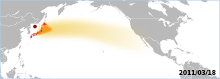
The Fukushima accident's radioactive plume. The map displays areas which have been overflown by the plume. Made by the Graphic Lab/Map workshop's wikigraphists (WP:GL/MAP) Sources 2011/03/18:
Note: Aeronobie.be now ask to cite and follow the Zamg.ac.at's page (currently the main source), stating: '--Varlaam 21:19, 24 March 2011 (UTC)'"The World Meteorological Organisation asked the Central Institute for Meteorology and Geodynamics (or ZAMG, Austria) to support the International Atomic Energy Agency by providing the atmospheric plume calculations." Background based on: A blank map of the world centred at the 180E longitude line. Detailed SVG map with grouping enabled to connect all non-contiguous parts of a country's territory for easy colouring. Smaller countries can also be represented by larger circles to show their data easier. A thorough description of use and other instructions relating to can be found on the instruction page |
||
| Час створення | (UTC) | ||
| Джерело | Власний твір заснований на: BlankMap-World-180E.svg | ||
| Автор | BlankMap-World-180E.svg: Lokal_Profil / похідний твір: Yug | ||
| SVG розвиток | Вихідний код цього SVG-файлу неправильний. Це векторне зображення було створено з допомогою Inkscape.
|
Ліцензування
| Я, власник авторських прав на цю роботу, передаю роботу в суспільне надбання. Застосовується по всьому світу. У деяких країнах це не може бути юридично можливо, в такому випадку: Я даю кожному право на використання цієї роботи для будь-яких цілей, без будь-яких умов, якщо такі умови не вимагаються за законом. |
Журнал завантажень локального файлу
This image is a derivative work of the following images:
- File:BlankMap-World-180E.svg licensed with PD-self
- 2008-04-13T22:24:07Z Lokal_Profil 940x477 (3620359 Bytes) {{Information |Description=A blank map of the world centered at the 180E longitude line. Detailed SVG map with grouping enabled to connect all non-contiguous parts of a country's territory for easy colouring. Smaller count
Uploaded with derivativeFX
Історія файлу
Клацніть на дату/час, щоб переглянути, як тоді виглядав файл.
| Дата/час | Мініатюра | Розмір об'єкта | Користувач | Коментар | |
|---|---|---|---|---|---|
| поточний | 15:06, 18 березня 2011 | 511 × 183 (2,86 МБ) | Yug | reduction of the area, the source go forward USA-Mexico, but don't reach them by 03/20. | |
| 13:18, 18 березня 2011 | 511 × 183 (2,86 МБ) | Yug | fix famous "black square bug" ;) | ||
| 13:06, 18 березня 2011 | 511 × 183 (2,86 МБ) | Yug | {{Information |Description=Fukushima accident's radioactive cloud. Made by the Graphic Lab/Map workshop's wikigraphists ([[:en:WP:GL/MAP) Sources 2011/03/18: * {{cite web|title=Nouvelle simulation du |
Використання файлу
Такі сторінки використовують цей файл:
Глобальне використання файлу
Цей файл використовують такі інші вікі:
- Використання в ca.wikipedia.org
- Використання в de.wikipedia.org
- Використання в de.wikinews.org
- Використання в en.wikipedia.org
- Використання в fr.wikipedia.org
- Використання в sh.wikipedia.org
- Використання в sr.wikipedia.org