Файл:Kilauea-falsecolor.jpg

Повна роздільність (1440 × 862 пікселів, розмір файлу: 137 КБ, MIME-тип: image/jpeg)
| Відомості про цей файл містяться на Вікісховищі — централізованому сховищі вільних файлів мультимедіа для використання у проектах Фонду Вікімедіа. |
Опис файлу
| Опис |
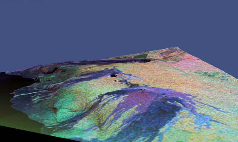
NASA space-radar false-color image of Kilauea, Hawaii. This is a three-dimensional perspective view of a false-color image of the eastern part of the Big Island of Hawaii. It was produced using all three radar frequencies -- X-band, C-band and L-band -- from the Spaceborne Imaging Radar-C/X-Band Synthetic Aperture Radar (SIR-C/X-SAR) flying on the space shuttle Endeavour, overlaid on a U.S. Geological Survey digital elevation map. Visible in the center of the image in blue are the summit crater (Kilauea Caldera) which contains the smaller Halemaumau Crater, and the line of collapse craters below them that form the Chain of Craters Road. The image was acquired on April 12, 1994 during orbit 52 of the space shuttle. The area shown is approximately 34 by 57 kilometers (21 by 35 miles) with the top of the image pointing toward northwest. The image is centered at about 155.25 degrees west longitude and 19.5 degrees north latitude. The false colors are created by displaying three radar channels of different frequency. Red areas correspond to high backscatter at L-HV polarization, while green areas exhibit high backscatter at C-HV polarization. Finally, blue shows high return at X-VV polarization. Using this color scheme, the rain forest appears bright on the image, while the green areas correspond to lower vegetation. The lava flows have different colors depending on their types and are easily recognizable due to their shapes. |
||||||||
| Час створення | |||||||||
| Джерело | http://photojournal.jpl.nasa.gov/catalog/PIA01717 | ||||||||
| Автор | NASA/JPL Caltech | ||||||||
| Ліцензія (Повторне використання цього файлу) |
|

Історія файлу
Клацніть на дату/час, щоб переглянути, як тоді виглядав файл.
| Дата/час | Мініатюра | Розмір об'єкта | Користувач | Коментар | |
|---|---|---|---|---|---|
| поточний | 15:37, 28 листопада 2005 | | 1440 × 862 (137 КБ) | Hike395 | NASA space-radar false-color image of Kilauea, Hawaii. Source URL: http://photojournal.jpl.nasa.gov/catalog/PIA01717 Courtesy NASA/JPL Caltech Source caption: This is a three-dimensional perspective view of a false-color image of the eastern part of th |
Використання файлу
Така сторінка використовує цей файл:
Глобальне використання файлу
Цей файл використовують такі інші вікі: