Файл:Le Mont St. Michel, Normandy, France. View, bilingual description and map.jpg
Перейти до навігації
Перейти до пошуку

Розмір при попередньому перегляді: 800 × 596 пікселів. Інші роздільності: 320 × 238 пікселів | 640 × 477 пікселів | 1024 × 763 пікселів | 1280 × 953 пікселів | 2560 × 1907 пікселів | 3797 × 2828 пікселів.
Повна роздільність (3797 × 2828 пікселів, розмір файлу: 3,11 МБ, MIME-тип: image/jpeg)
| Відомості про цей файл містяться на Вікісховищі — централізованому сховищі вільних файлів мультимедіа для використання у проектах Фонду Вікімедіа. |
Опис файлу
| Опис |
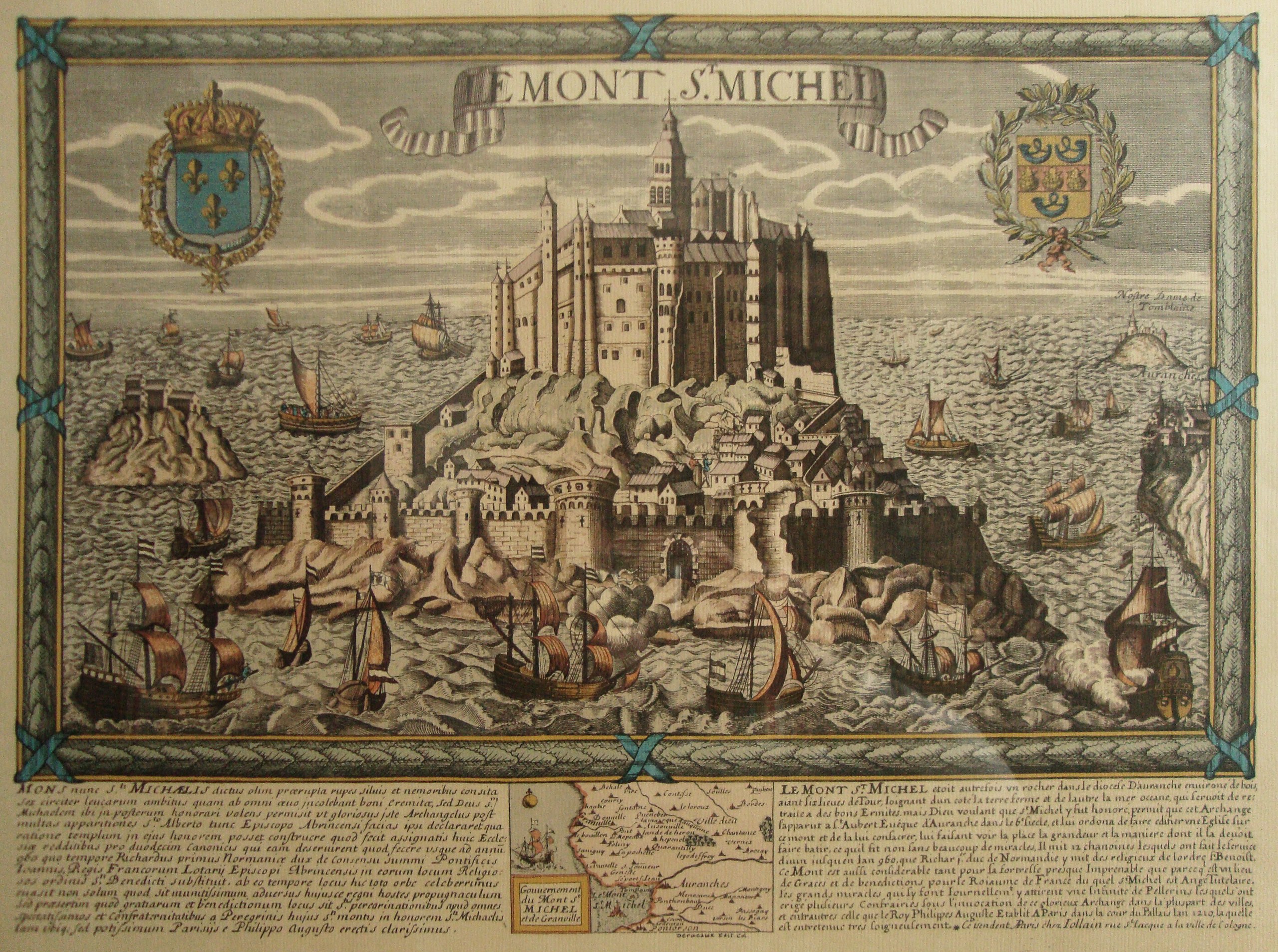
English: Le Mont St. Michel, Normandy, France. It is a map (date between late XVIII and early XIX centuries; personal library) that comprises an old view, with a bilingual historical description, of the place (Latin and French) and map. Made by Daniel Louis Derveaux (1914-2010). Although the images collected at http://en.wikipedia.org/wiki/Mont_Saint-Michel#Development suggest that this engraving is wrong due to the central and higher tower, which is represented in its actual shape in the maquette corresponding to the XX century, resembles to the present one, but not to that represented in the maquette corresponding to XVII-XVIII centuries, this engraving has to be dated so far to the last days of the monarchy in the late XVIII century, or during the brief Bourbon restoration of XIX century, due to the Royal Coat of Arms of the Kingdom of France, at the left upper corner of the engraving. Also, the image at http://www.vintage-maps.com/en/Antique-Maps/Europe/France/Merian-France-Mont-Saint-Michel-1657::401.html?XTCsid=2204da727b878fd7bc48a0c7a424cb01, which correspond to a view of the XVII century, shows the same same central and higher tower in the shape that has this uploaded image, instead of resembling that of the maquette 3, corresponding to XVII-XVIII centuries. Typographical characters suggest XVIII century.
Español: El Monte San Miguel, en Normandía, Francia. Se trata de un mapa, datable a fines del s. XVIII o a principios del s. XIX, que reune en una pieza la vista del sitio, su descripción histórica bilingüe (latín y francés), y un mapa propiamente dicho. Hecho por Daniel Louis Derveaux (1914-2010). Aunque las imágenes reunidas en http://en.wikipedia.org/wiki/Mont_Saint-Michel#Development sugieren que este grabado es apócrifo, debido a que la torre central, más alta, que es representada en su forma presente en la maqueta que corresponde al siglo XX, se asemeja a la de esta imagen, pero no a aquella representada en la maqueta que corresponde a los siglos XVII-XVIII, este grabado debería ser datado a más tardar fines del s. XVIII o, cuanto más reciente, a principios del s. XIX, por razón del escudo de armas real en la esquina superior izquierda. Además, la imagen en http://www.vintage-maps.com/en/Antique-Maps/Europe/France/Merian-France-Mont-Saint-Michel-1657::401.html?XTCsid=2204da727b878fd7bc48a0c7a424cb01 muestra la misma torre central en la figura que tiene en esta imagen, en lugar de la forma sugerida por la recreación de la maqueta 3, correspondiente a los ss. XVII-XVIII. La tipografía sugiere que es del s. XVIII. |
| Час створення | Without date: late XVIII century or early XIX century. Typographical characters suggest XVIII century. / Sin fecha: datable a fines del s. XVIII o a principios del s. XIX. La tipografía sugiere que es del s. XVIII. |
| Джерело | Власна робота;just for the photograph; it is an antique work./Trabajo propio en lo que concierne a la fotografía, pues la obra retratada es antigua. |
| Автор | Rhurtadon; but just for the photograph. Te map it self seems to be made by some Deracaux./ La obra en sí misma fue hecha por cierto Deracaux. |
| Ліцензія (Повторне використання цього файлу) |
All granted. / Todos concedidos. |
| Місцеположення камери | | Перегляньте це та інші зображення поблизу на: OpenStreetMap |
|---|
Ліцензування
Я, власник авторських прав на цей твір, добровільно публікую його на умовах таких ліцензій:

|
Дозволяється копіювати, розповсюджувати та/або модифікувати цей документ на умовах ліцензії GNU FDL версії 1.2 або більш пізньої, виданої Фондом вільного програмного забезпечення, без незмінних розділів, без текстів, які розміщені на першій та останній обкладинці. Копія ліцензії знаходиться у розділі GNU Free Documentation License. |
This file is licensed under the Creative Commons Attribution-Share Alike 4.0 International, 3.0 Unported, 2.5 Generic, 2.0 Generic and 1.0 Generic license.
- Ви можете вільно:
- ділитися – копіювати, поширювати і передавати твір
- модифікувати – переробляти твір
- При дотриманні таких умов:
- зазначення авторства – Ви повинні вказати авторство, надати посилання на ліцензію і вказати, чи якісь зміни було внесено до оригінального твору. Ви можете зробити це в будь-який розсудливий спосіб, але так, щоб він жодним чином не натякав на те, наче ліцензіар підтримує Вас чи Ваш спосіб використання твору.
- поширення на тих же умовах – Якщо ви змінюєте, перетворюєте або створюєте іншу похідну роботу на основі цього твору, ви можете поширювати отриманий у результаті твір тільки на умовах такої ж або сумісної ліцензії.
Ви можете обрати ліцензію на ваш розсуд.
Історія файлу
Клацніть на дату/час, щоб переглянути, як тоді виглядав файл.
| Дата/час | Мініатюра | Розмір об'єкта | Користувач | Коментар | |
|---|---|---|---|---|---|
| поточний | 08:22, 28 лютого 2014 | | 3797 × 2828 (3,11 МБ) | MartinoK | Lens correction, colour cleansing, undistorted and rotated. |
| 03:06, 11 травня 2010 |  | 4000 × 3000 (4,12 МБ) | Rhurtadon | {{Information |Description={{en|1=Le Mont St. Michel, Normandy, France. It is a map (date between late XVIII and early XIX centuries) that comprises an old view, with a bilingual description, of the place (Latin and French) and map. Made by some Deracaux. |
Використання файлу
Така сторінка використовує цей файл:
Глобальне використання файлу
Цей файл використовують такі інші вікі:
- Використання в ca.wikipedia.org
- Використання в es.wikipedia.org
- Використання в fr.wikipedia.org