Файл:NorthNatalWarTheatre, colour, crop.png
Повна роздільність (730 × 1006 пікселів, розмір файлу: 90 КБ, MIME-тип: image/png)
| Відомості про цей файл містяться на Вікісховищі — централізованому сховищі вільних файлів мультимедіа для використання у проектах Фонду Вікімедіа. |
Опис файлу
| Опис |
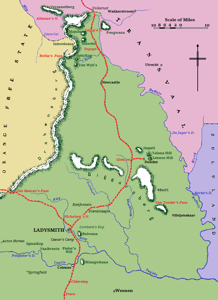
English: Map of the North Natal war theatre during the Second Anglo-Boer War.
Colony of Natal
Hills and mountains
Orange Free State
Transvaal (or South African Republic)
Zululand
|
| Час створення | |
| Джерело | Анонім (1910) A Handbook of the Boer War - With General Map of South Africa and 18 Sketch Maps and Plans, London & Aldershot: Gale & Polden Ltd |
| Автор | Anonymous - marketed by Sutton, Praed & Co (cartographer) |
| Інші версії |
  |
| Місцеположення об’єкта | | Перегляньте це та інші зображення поблизу на: OpenStreetMap |
|---|
Ліцензування
Цей файл перебуває в суспільному надбанні в США. Це стосується робіт, опублікованих в США, термін дії авторського права який сплинув, оскільки вони були опубліковані до 1 січня 1929. Див. тут для подробиць.
|
 | |
 |
Цей файл може не перебувати в суспільному надбанні поза США, в особливості в країнах без правила порівняння термінів для робіт зі США, наприклад у Канаді, Китаї (без Гонконга та Макао), Німеччині, Мексиці та Швейцарії. Автор та рік публікації є необхідною інформацією та мають бути вказані. Див. Wikipedia:Public domain and Вікіпедія:Авторські права для подробиць.
|
This work was first published in South Africa and is now in the public domain because its copyright protection has expired by virtue of the Copyright Act No. 98 of 1978, amended 2002. The work meets one of the following criteria:
A South African work that is in the public domain in South Africa according to this rule is in the public domain in the U.S. only if it was in the public domain in South Africa in 1996, e.g. if it was published before 1946 and no copyright was registered in the U.S. (This is the effect of 17 USC 104A with its critical date of January 1, 1996.) |
 |
| This image comes from the Project Gutenberg archives. This is an image that has come from a book or document for which the American copyright has expired and this image is in the public domain in the United States and possibly other countries.
This eBook is for the use of anyone anywhere at no cost and with almost no restrictions whatsoever. You may copy it, give it away or re-use it under the terms of the Project Gutenberg License included with this eBook or online at www.gutenberg.net. |
Історія файлу
Клацніть на дату/час, щоб переглянути, як тоді виглядав файл.
| Дата/час | Мініатюра | Розмір об'єкта | Користувач | Коментар | |
|---|---|---|---|---|---|
| поточний | 19:41, 14 серпня 2019 | | 730 × 1006 (90 КБ) | JMK | clarity |
| 20:03, 16 травня 2019 |  | 730 × 1006 (64 КБ) | JMK | clarity | |
| 17:19, 24 квітня 2019 |  | 730 × 1006 (60 КБ) | JMK | {{Information |description ={{en|1=Map of the North Natal war theatre during the Second Anglo-Boer War.}} |date =1910 |source =http://www.gutenberg.org/files/15699/15699-h/15699-h.htm |author ={{anonymous}} }} Category:Maps of the Second Boer War |
Використання файлу
Така сторінка використовує цей файл:
Глобальне використання файлу
Цей файл використовують такі інші вікі:
- Використання в af.wikipedia.org
- Використання в en.wikipedia.org
- Використання в eo.wikipedia.org
- Використання в ru.wikipedia.org