Файл:Paraná River Floodplain, Northern Argentina.jpg

Повна роздільність (4288 × 2850 пікселів, розмір файлу: 3,8 МБ, MIME-тип: image/jpeg)
| Відомості про цей файл містяться на Вікісховищі — централізованому сховищі вільних файлів мультимедіа для використання у проектах Фонду Вікімедіа. |
Опис файлу
| Опис |
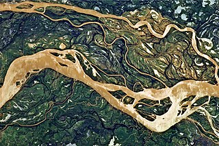
English: This astronaut photograph shows a 29-kilometre stretch of the Paraná, downstream of the small city of Goya, Argentina (just off the top left of the image).
The Paraná River ranges up to 3 kilometres wide along the reach illustrated in this image. The main channel is deep enough to allow smaller ocean-going ships to pass north to the capital city of Asunción, Paraguay, fully 1,200 kilometres inland and well out of the image. The river’s dark brown shading indicates a heavy load of muddy sediment; smaller side channels also carry this mud. Numerous lakes are typical on active floodplains, and appear here as irregular bodies of water. Some appear brown, indicating that they probably have been refilled during recent rises and floods of the active channels. The Paraná floodplain occupies the entire image; it is so wide—18 kilometres in this view—that its banks are not visible. Numerous curved, meandering channels are the most prominent characteristic of the floodplain, indicating prior positions of the river and its channels. As riverbeds move laterally by natural processes, they leave remnants of their channels, which appear as lakes and finally fill with mud. This is an excellent image for illustrating these meander forms. From a geological standpoint, it is interesting that almost all of the old channels are similar in curvature to today’s side channels. However, almost none of them seem to show prior positions of the main, wide Paraná channel. |
| Час створення | |
| Джерело | NASA Earth Observatory |
| Автор | ISS Expedition 27 crew |
| Місцеположення камери | | Перегляньте це та інші зображення поблизу на: OpenStreetMap |
|---|
Це зображення або відео внесене у каталог Космічного центру Ліндона Джонсона Національного управління з аеронавтики і дослідження космічного простору США (NASA)під фото ID: ISS027-E-11058. Це не тег авторських прав. Дійсна ліцензія має додаватись до цього тегу. Інші мови:
|
Image acquired with a Nikon D2Xs digital camera using a 400 mm lens, and is provided by the ISS Crew Earth Observations experiment and Image Science & Analysis Laboratory, Johnson Space Center.
Ліцензування
| Цей файл перебуває у суспільному надбанні, оскільки він був створений NASA (Національним управлінням з аеронавтики і дослідження космічного простору). Згідно з політикою NASA стосовно авторського права, «матеріали NASA не захищаються авторським правом, якщо не вказано протилежне». (Див. Template:PD-USGov, сторінку політики NASA стосовно авторського права, або політику використання зображень JPL.) | ||
 |
Попередження:
|
| Анотації | Це зображення має анотації: Переглянути анотації на Вікісховищі |
Історія файлу
Клацніть на дату/час, щоб переглянути, як тоді виглядав файл.
| Дата/час | Мініатюра | Розмір об'єкта | Користувач | Коментар | |
|---|---|---|---|---|---|
| поточний | 11:54, 2 травня 2011 | | 4288 × 2850 (3,8 МБ) | Originalwana |
Використання файлу
Така сторінка використовує цей файл:
Глобальне використання файлу
Цей файл використовують такі інші вікі:
- Використання в ar.wikipedia.org
- Використання в de.wikipedia.org
- Використання в en.wikipedia.org
- Використання в eo.wikipedia.org
- Використання в fa.wikipedia.org
- Використання в he.wikipedia.org
- Використання в ko.wikipedia.org
- Використання в mk.wikipedia.org
- Використання в ml.wikipedia.org
- Використання в sr.wikipedia.org
- Використання в ur.wikipedia.org