Файл:Tarso Toh.jpg
Перейти до навігації
Перейти до пошуку
Нема версії з більшою роздільністю.
Tarso_Toh.jpg (640 × 458 пікселів, розмір файлу: 164 КБ, MIME-тип: image/jpeg)
| Відомості про цей файл містяться на Вікісховищі — централізованому сховищі вільних файлів мультимедіа для використання у проектах Фонду Вікімедіа. |
Опис файлу
| Опис |
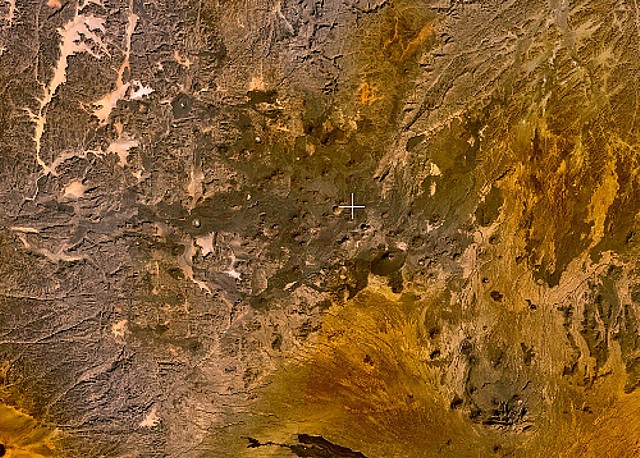
English: Small cinder cones and lava flows of the Tarso Tôh volcanic field can be seen in the large darker-brownish area at the center of this NASA Landsat image. This Pleistocene-to-Holocene volcanic field in the Tibesti Range of Chad covers a 30 x 80 km area and contains 150 scoria cones and two maars. Basaltic lava flows at Tarso Tôh were erupted over a basement of Precambrian schists and Paleozoic sandstones. The black lava flows at the very bottom-center are distal lava flows from Tarso Toussidé volcano. |
| Час створення | Невідома дата |
| Джерело | http://www.volcano.si.edu/world/volcano.cfm?vnum=0205-009&volpage=photos&photo=119033 |
| Автор | NASA Landsat7 image (worldwind.arc.nasa.gov) |
Ліцензування
| This image is in the public domain because it is a screenshot from NASA’s globe software World Wind using a public domain layer, such as Blue Marble, MODIS, Landsat, SRTM, USGS or GLOBE.
|
 |
Історія файлу
Клацніть на дату/час, щоб переглянути, як тоді виглядав файл.
| Дата/час | Мініатюра | Розмір об'єкта | Користувач | Коментар | |
|---|---|---|---|---|---|
| поточний | 23:28, 22 червня 2010 | | 640 × 458 (164 КБ) | Michael Metzger | {{Information |Description={{en|1=Small cinder cones and lava flows of the Tarso Tôh volcanic field can be seen in the large darker-brownish area at the center of this NASA Landsat image. This Pleistocene-to-Holocene volcanic field in the Tibesti Range o |
Використання файлу
Така сторінка використовує цей файл:
Глобальне використання файлу
Цей файл використовують такі інші вікі:
- Використання в cs.wikipedia.org
- Використання в de.wikipedia.org
- Використання в en.wikipedia.org
- Використання в fa.wikipedia.org
- Використання в fr.wikipedia.org
- Використання в ru.wikipedia.org
- Використання в sk.wikipedia.org
- Використання в www.wikidata.org