Файл:Titan map April 2011 full.png

Повна роздільність (4046 × 2023 пікселів, розмір файлу: 4,74 МБ, MIME-тип: image/png)
| Відомості про цей файл містяться на Вікісховищі — централізованому сховищі вільних файлів мультимедіа для використання у проектах Фонду Вікімедіа. |
Опис файлу
| Опис |
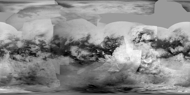
English: This global digital map of Saturn's moon Titan was created using images taken by the Cassini spacecraft's imaging science subsystem (ISS).
The images were taken using a filter centered at 938 nanometers, allowing researchers to examine variations in albedo (or inherent brightness) variations across the surface of Titan. Because of the scattering of light by Titan's dense atmosphere, no topographic shading is visible in these images. The map is an equidistant projection and has a scale of 2.5 miles (4 kilometers) per pixel. Actual resolution varies greatly across the map, with the best coverage (close to the map scale) along the equator near the center of the map at 180 degrees west longitude and near the left and right edges at 0 and 360 degrees west longitude. The worst coverage is on the leading hemisphere (particularly around 120 degrees west longitude) and in some northern latitudes. Coverage in the northern polar region continues to improve as the north pole comes out of shadow after Titan's northern vernal equinox in August 2009. Large dark areas, now known to be liquid-hydrocarbon-filled lakes, have been documented at high latitudes (see PIA11146). This map is an update to the version released in February 2009 (see PIA11149). Data from the last two years, including the most recent data in the map from April 2011, have improved coverage in the southern trailing hemisphere and over portions of the north polar region. The mean radius of Titan used for projection of this map is 1,600 miles (2,575 kilometers). Titan is assumed to be spherical until a control network -- or model of the moon's shape based on multiple images tied together at defined points on the surface -- is created at some point in the future. |
| Час створення | |
| Джерело | http://photojournal.jpl.nasa.gov/catalog/PIA14908 |
| Автор | NASA |
Ліцензування
| Цей файл перебуває у суспільному надбанні, оскільки він був створений NASA (Національним управлінням з аеронавтики і дослідження космічного простору). Згідно з політикою NASA стосовно авторського права, «матеріали NASA не захищаються авторським правом, якщо не вказано протилежне». (Див. Template:PD-USGov, сторінку політики NASA стосовно авторського права, або політику використання зображень JPL.) | ||
 |
Попередження:
|
Історія файлу
Клацніть на дату/час, щоб переглянути, як тоді виглядав файл.
| Дата/час | Мініатюра | Розмір об'єкта | Користувач | Коментар | |
|---|---|---|---|---|---|
| поточний | 23:49, 23 червня 2014 | | 4046 × 2023 (4,74 МБ) | Sneeuwschaap | User created page with UploadWizard |
Використання файлу
Такі сторінки використовують цей файл:
Глобальне використання файлу
Цей файл використовують такі інші вікі:
- Використання в ru.wikipedia.org
- Ксанаду (Титан)
- Шаблон:ПозКарта Титан
- Озеро Онтарио (Титан)
- Менрва (кратер)
- Афекан (кратер)
- Селк (кратер)
- Синлап (кратер)
- Кса (кратер)
- Момой (кратер)
- Сой (кратер)
- Хано (кратер)
- Адири (Титан)
- Дильмун (Титан)
- Кивира (Титан)
- Цегихи (Титан)
- Белет (Титан)
- Аару (Титан)
- Ацтлан (Титан)
- Чинг-ту (Титан)
- Шангри-Ла (Титан)
- Фенсал (Титан)
- Сэнкё (Титан)
- Меццорамия (Титан)
- Дуга Хотэя
- Факула Крит
- Факулы Никобар
- Факула Оаху
- Факула Сикоку
- Факулы Антилия
- Факула Эльба
- Патера Сотра
- Факула Базаруто
- Факула Вис
- Факула Минданао
- Факула Тексел
- Факула Санторини
- Факула Кергелен
- Факула Котс
- Факула Тортола
- Поток Ары
- Поток Мохини
- Поток Лейлы
- Поток Винии
- Поток Роэ
- Каналы Эливагар
- Остров Майда
- Лабиринт Сикун
- Макула Ганеши
- Макула Элпис
- Макула Омакатля
Переглянути сторінку глобального використання цього файлу.