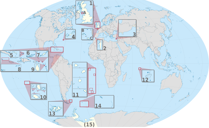
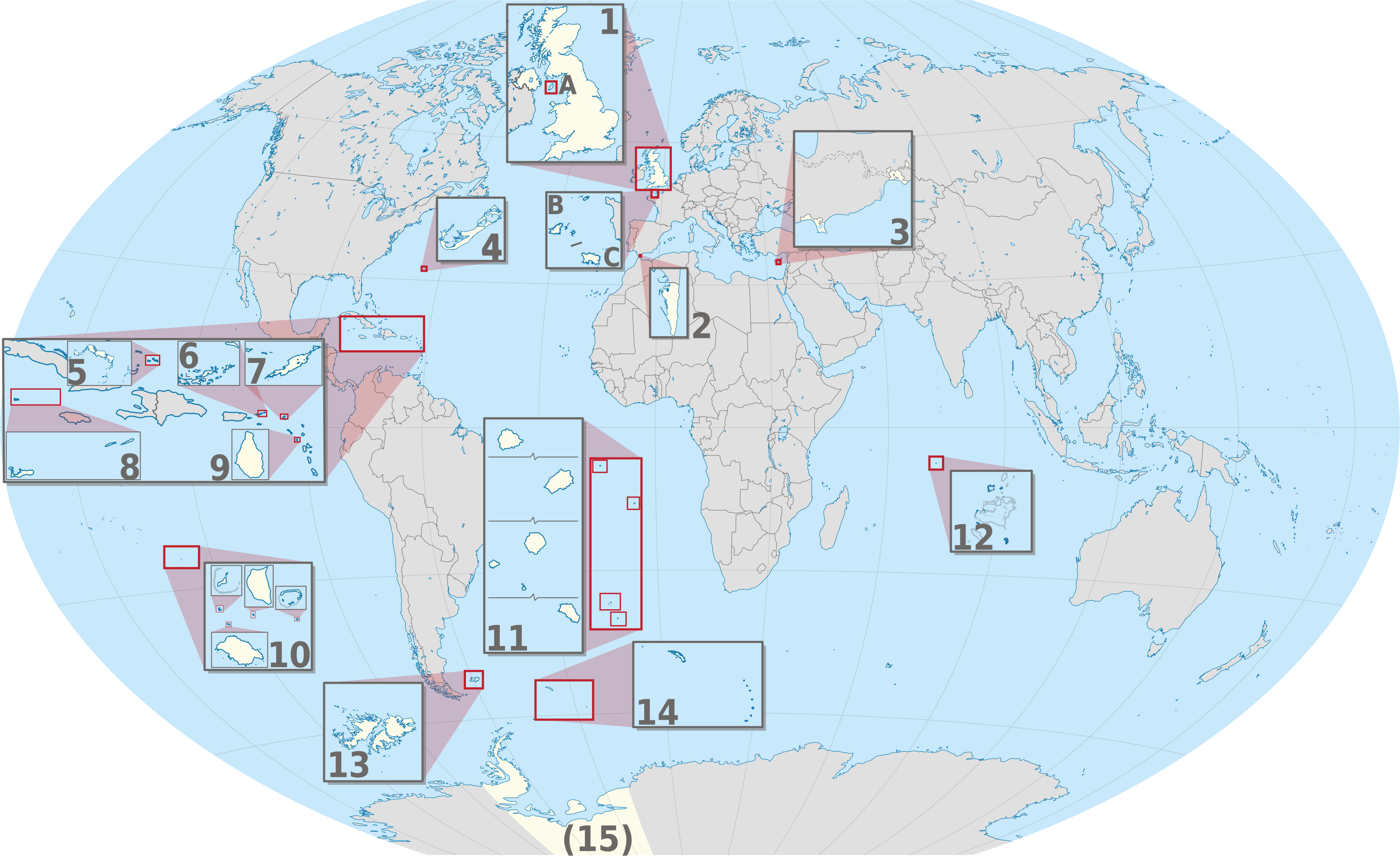
Файл:United Kingdom (overseas+crown dependencies), administrative divisions - Nmbrs (multiple zoom).svg
Перейти до навігації
Перейти до пошуку

Розмір цього попереднього перегляду PNG для вихідного SVG-файлу: 800 × 493 пікселів. Інші роздільності: 320 × 197 пікселів | 640 × 394 пікселів | 1024 × 631 пікселів | 1280 × 789 пікселів | 2560 × 1577 пікселів | 3188 × 1964 пікселів.
Повна роздільність (SVG-файл, номінально 3188 × 1964 пікселів, розмір файлу: 6,04 МБ)
| Відомості про цей файл містяться на Вікісховищі — централізованому сховищі вільних файлів мультимедіа для використання у проектах Фонду Вікімедіа. |
Опис файлу


.svg)


_(Paris_zoom).svg)
.svg)
,_administrative_divisions_-_de_-_colored_(multizoom).svg)
_-_colored.svg)
.svg)
,_administrative_divisions_-_Nmbrs_(multizoom).svg)
,_administrative_divisions_-_de_-_colored.svg)
_-_de_-_colored.svg)

.svg)

.svg)
,_administrative_divisions_-_Nmbrs_(multiple_zoom).svg)
_(W3).svg)
Ліцензування
Я, власник авторських прав на цей твір, добровільно публікую його на умовах такої ліцензії:
Цей файл доступний на умовах ліцензії Creative Commons Attribution-Share Alike 2.0 Generic
- Ви можете вільно:
- ділитися – копіювати, поширювати і передавати твір
- модифікувати – переробляти твір
- При дотриманні таких умов:
- зазначення авторства – Ви повинні вказати авторство, надати посилання на ліцензію і вказати, чи якісь зміни було внесено до оригінального твору. Ви можете зробити це в будь-який розсудливий спосіб, але так, щоб він жодним чином не натякав на те, наче ліцензіар підтримує Вас чи Ваш спосіб використання твору.
- поширення на тих же умовах – Якщо ви змінюєте, перетворюєте або створюєте іншу похідну роботу на основі цього твору, ви можете поширювати отриманий у результаті твір тільки на умовах такої ж або сумісної ліцензії.

|
I'd greatly appreciate, that you attribute this media file to Wikimedia Commons, if used outside Wikipedia or Commons. For use in publications such as books, newspapers, blogs, websites, please insert here the following line:
|
,_administrative_divisions_-_Nmbrs_(multiple_zoom).svg)
Історія файлу
Клацніть на дату/час, щоб переглянути, як тоді виглядав файл.
| Дата/час | Мініатюра | Розмір об'єкта | Користувач | Коментар | |
|---|---|---|---|---|---|
| поточний | 21:30, 2 вересня 2013 | | 3188 × 1964 (6,04 МБ) | TUBS | |
| 11:04, 20 червня 2012 |  | 3188 × 1964 (6,02 МБ) | TUBS | == {{int:filedesc}} == {{Information |Description={{de|Karte der politischen Gliederung von XY (siehe Dateiname)}} {{en|Map of administrative divisions of XY (see filename)}} |Source={{own}}{{Adobe Illustrator}}{{Commonist}}{{AttribSVG|United Kingdom ... |
Використання файлу
Така сторінка використовує цей файл:
Глобальне використання файлу
Цей файл використовують такі інші вікі:
- Використання в am.wikipedia.org
- Використання в bn.wikipedia.org
- Використання в ca.wikipedia.org
- Використання в en.wikivoyage.org
- Використання в ja.wikipedia.org
- Використання в or.wikipedia.org
- Використання в pnb.wikipedia.org
- Використання в pt.wikipedia.org
- Використання в ro.wikipedia.org
- Використання в tr.wikipedia.org
- Використання в ur.wikipedia.org
- Використання в vi.wikipedia.org
- Використання в zh.wikipedia.org
,_administrative_divisions_-_Nmbrs_(multiple_zoom).svg)