Файл:Wfm jura landsat.jpg
Перейти до навігації
Перейти до пошуку

Розмір при попередньому перегляді: 800 × 593 пікселів. Інші роздільності: 320 × 237 пікселів | 640 × 474 пікселів | 1024 × 758 пікселів | 1280 × 948 пікселів.
Повна роздільність (1280 × 948 пікселів, розмір файлу: 328 КБ, MIME-тип: image/jpeg)
| Відомості про цей файл містяться на Вікісховищі — централізованому сховищі вільних файлів мультимедіа для використання у проектах Фонду Вікімедіа. |
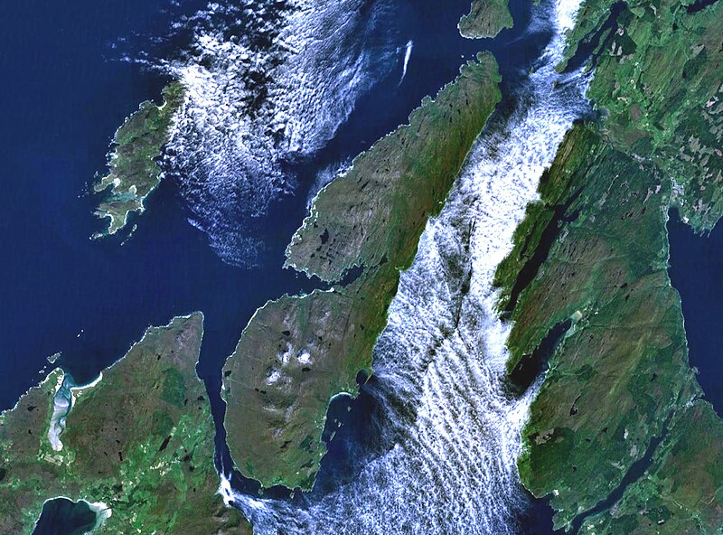
The island of Jura off the west coast of Scotland. The large island to the southwest is Islay, and north of it is Colonsay. To the east is the Kintyre peninsula. The small round island just to the north is Scarba.
This is Landsat7 imagery, collected using NASA World Wind.
| This image is in the public domain because it is a screenshot from NASA’s globe software World Wind using a public domain layer, such as Blue Marble, MODIS, Landsat, SRTM, USGS or GLOBE.
|
 |
Історія файлу
Клацніть на дату/час, щоб переглянути, як тоді виглядав файл.
| Дата/час | Мініатюра | Розмір об'єкта | Користувач | Коментар | |
|---|---|---|---|---|---|
| поточний | 19:48, 4 серпня 2005 | | 1280 × 948 (328 КБ) | Finlay McWalter | The island of Jura off the west coast of Scotland. This is Landsat7 imagery, collected using NASA World Wind. {{PD-USGov-NASA}} category:islands category:scotland category:satellite photos |
Використання файлу
Така сторінка використовує цей файл:
Глобальне використання файлу
Цей файл використовують такі інші вікі:
- Використання в br.wikipedia.org
- Використання в cs.wikipedia.org
- Використання в de.wikipedia.org
- Використання в el.wikipedia.org
- Використання в en.wikipedia.org
- Scarba
- Craighouse
- Feolin
- Beinn an Òir
- Beinn Shiantaidh
- Beinn a' Chaolais
- Paps of Jura
- Ardfernal
- Ardmenish
- Jura, Scotland
- Barnhill, Jura
- List of listed buildings in Jura, Argyll and Bute
- Ardlussa Fishing Loch
- Ardfin
- Small Isles, Argyll
- Template:Jura
- Am Fraoch Eilean
- Brosdale Island
- Lagg, Jura
- Tarbert, Jura
- Keils
- Inverlussa
- Kinuachdrachd
- Ardlussa
- Knockrome
- Використання в en.wiktionary.org
- Використання в es.wikipedia.org
- Використання в fr.wikipedia.org
- Використання в gl.wikipedia.org
- Використання в it.wikipedia.org
- Використання в ja.wikipedia.org
- Використання в la.wikipedia.org
- Використання в nds.wikipedia.org
- Використання в nl.wikipedia.org
- Використання в nn.wikipedia.org
- Використання в no.wikipedia.org
- Використання в pl.wikipedia.org
- Використання в pt.wikipedia.org
- Використання в sr.wikipedia.org
- Використання в sv.wikipedia.org
- Використання в www.wikidata.org