Файл:World98.svg

Повна роздільність (SVG-файл, номінально 8000 × 3859 пікселів, розмір файлу: 9,3 МБ)
| Відомості про цей файл містяться на Вікісховищі — централізованому сховищі вільних файлів мультимедіа для використання у проектах Фонду Вікімедіа. |

NOTE!
This file is HUGE. It cannot open in inkscape with 2GB of memory, or probably with 4GB either (however, gimp or a similar program should be able to generate a thumbnail without keeping the whole image in core). In other words, you will most likely be unable to open this on a 32-bit computer. It is only intended for use by other wiki map geeks to generate smaller SVG maps of countries and regions. Also note that, whenever possible it is better to use one of the continental maps that came from the same source, as they are more usable (won't eat all your system memory) and more precise (16 digits instead of 12):
- Image:africa98.svg
- Image:asia98.svg
- Image:europe98.svg
- Image:south_america98.svg
- Image:oceania98.svg
- Image:north_america98.svg
Опис файлу
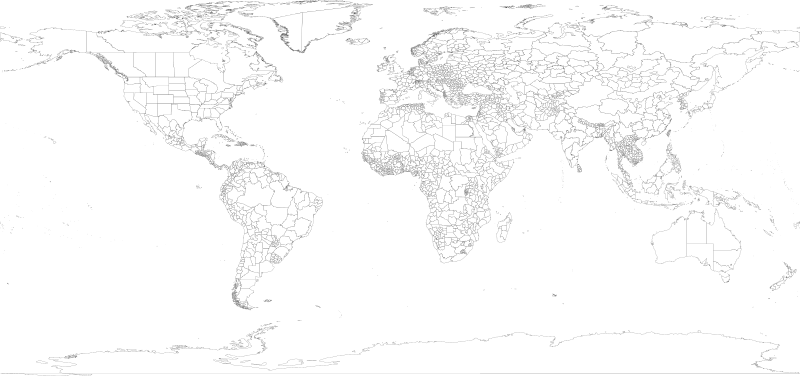
| Опис | 1998 World map with first level administrative units. |
| Час створення | |
| Джерело | world98.shp from the US CDC [1] |
| Автор | Translated to SVG by User:Brianski |
| Інші версії |
|
| SVG розвиток | Вихідний код цього вели́кий SVG-файлу правильний. Це вели́кий векторне зображення було створено з допомогою Other tools |

TODO
- Find the right projection for and generate an antarctica98.svg
- Some submaps that don't follow continental boundaries might be handy, e.g. carribean98.svg, middle_east98.svg, mediterranean98.svg, se_asia_and_australia98.svg, etc.
- Fix blips in USA (Utah, PA, Michigan, etc.), west Antarctica. change background color so these blips are more obvious and thus easier to fix.
- Also group properly. IE: There shouldn't be >50 seperate USA groups for each state/territory, instead they should be nested together in a common USA group.
- Make copies of this map with country borders shown in darker lines.
- The territory of Nunavut was formed in 1999, giving Canada three territories in the north - not the 2 displayed here.
Generation Notes
perl xml2svg.pl -P12 --proj=cylindrical_equidistant:0,0.793353340291235 -x8000 world98
Ліцензування
Це зображення є роботою працівника Центру контролю та запобігання хвороб (агентство Міністерства охорони здоров'я і соціальних служб США), зробленою чи сфотографованою ним як частина його обов'язків. Як робота Федерального уряду США, це зображення перебуває в суспільному надбанні в США.
|
Історія файлу
Клацніть на дату/час, щоб переглянути, як тоді виглядав файл.
| Дата/час | Мініатюра | Розмір об'єкта | Користувач | Коментар | |
|---|---|---|---|---|---|
| поточний | 17:18, 28 червня 2018 | | 8000 × 3859 (9,3 МБ) | JoKalliauer | fixed 2735 W3C-erros (now valid); removed Category:SVG files with multiple W3C-errors |
| 05:45, 21 жовтня 2007 |  | 8000 × 3859 (18,89 МБ) | Brianski | fix greenland bug | |
| 04:35, 21 жовтня 2007 |  | 8000 × 3859 (18,89 МБ) | Brianski | use 8000 width (instead of 800) so that borders aren't so huge | |
| 04:16, 21 жовтня 2007 |  | 512 × 247 (18,89 МБ) | Brianski | Switch to equidistant cylindrical projection @37.5 degrees (aka first miller equidistant cylindrical projection - http://mathworld.wolfram.com/MillerEquidistantProjection.html) | |
| 03:25, 21 жовтня 2007 |  | 512 × 499 (18,89 МБ) | Brianski | {{Information |Description=1998 World map with first level administrative units. |Source=world98.shp from the en:CDC [http://www.cdc.gov/epiinfo/documents/shapes.doc] |Date=2007/10/20 |Author=Translated to SVG by User:Brianski }} |
Використання файлу
Така сторінка використовує цей файл:
Глобальне використання файлу
Цей файл використовують такі інші вікі:
- Використання в en.wikipedia.org
- Використання в zh.wikipedia.org