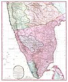
English: This map (noted as "Third Edition"), created immediately after the
Fourth Anglo-Mysore War (1798–1799), is based on the
1793 Faden map (without any version note), created immediately after the
Third Anglo-Mysore War (1789-92) and the subsequent division of and territorial loss by the
Kingdom of Mysore through the 1792
Treaty of Seringapatam. The only difference from the older map is in political territory, showing vast expansion of the territory of the British East India Company (over that gained by the 1792 Treaty of Seringapatam), and the now much smaller
Princely State of Mysore, after the Kingdom of Mysore having further lost territory to the East India Company's
Madras Presidency, and one of the company's allies in the Anglo-Mysore Wars, the
Princely state (from 1798) of
Hyderabad state (contemporary sources refer to its hereditary ruler, the
Nizam (of Hyderabad) in place of his territories).
The original 1773 map, with this map showing only territorial changes, was, according to the notes on the map, "compiled chiefly from papers communicated by the late Sir Archibald Campbell, the surveys of Col. Kelly, Capt. Pringle, Capt. Allan, etc." by Major James Rennell, and not based on his own surveys as Surveyor-General of the British East India Company, which were conducted in the Ganges basin.
Description from Geographicus: This is James Rennell's magnificent mapping of the Indian subcontinent, one of the largest and most impressive maps of India to appear in the 18th century. Highly desirable third edition. Presented in two panels, as issued. This chart depicts the subcontinent from Bombay ( Mumbai ) and Aurangabad, south including the northern half of Sri Lanka (Ceylon). Color coded according to political territory, noting British Possessions (red), the territory claimed by the independent holdout Rajah of Mysore (Purple), the Marhatta Countries (Green), the Nizam Dominions (Orange), the Carnatick (Yellow), and the Travancore (Blue). Includes the routes of various military marches and campaigns relating to the British conquest of India, including the 1784 March of British Prisoners from Condapoor to Madras, the march of the Marquis of Cornwallis, the march of General Medows, and the march of General Abercromby. Also shows the acquisitions of the British through the Partition Treaty of 1792. This map was engraved by R. Baker and printed in by William Faden, “Royal Geographer to the King and to the Prince of Wales”. The whole is masterfully presented in visually stunning almost three dimensional engraving and stunning period color. A must for any serious collection of South Asia maps. Compiled by James Rennell from papers communicated by the late Sir Archibald Campbell, the surveys of Col. Kelly, Capt. Pringle, Capt. Allan, etc.


