Файл:Flag of Bosnia and Herzegovina (construction sheet).svg

Повна роздільність (SVG-файл, номінально 1290 × 690 пікселів, розмір файлу: 16 КБ)
| Відомості про цей файл містяться на Вікісховищі — централізованому сховищі вільних файлів мультимедіа для використання у проектах Фонду Вікімедіа. |
.svg)
Опис файлу
| Опис |
English: Flag of Bosnia and Herzegovina — construction sheet |
| Час створення | |
| Джерело |
Власна робота. This construction sheet is derived from multiple sources:
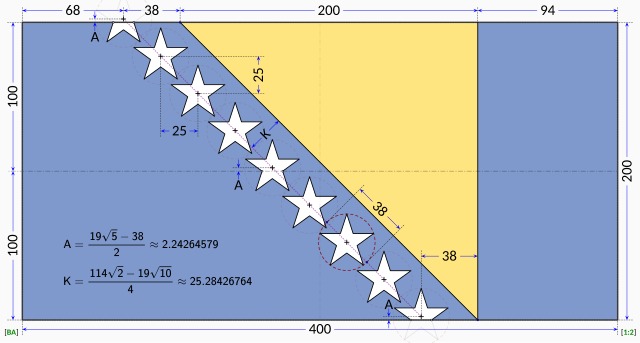
The specification drawing provides:
The triangle is isosceles with one edge running at 45° relative to the edges of the flag. According to the law, the stars are supposed to parallel to the triangle's edge, so it stands that the line of stars must run in a precise 45° line. The law does not explicitly dictate the precise placement of the stars. Close examination of the government EPS drawing reveals most of the intended geometry:
The only missing information is the precise horizontal positioning of the line of stars. Based on measurements from the government EPS drawing, the vertical centerline of the centre star is located at distance from the hoist that is roughly 42.4% of the length of the flag. The centre star was chosen for the measurement because the line of stars in the EPS drawing runs at about 45.5° instead of the 45° dictated by the law. The same measurement repeated on the specification drawing reveals a distance of about 41.8% of the length of the flag with the line of stars again at 45.5°. For the purpose of this Wikimedia construction sheet, the distance from the hoist to the vertical centerline of the centre star is assumed to be exactly 42.0% of the length of the flag. All the other stars are laid out with equal spacing on a precise 45° degree line. Vertical coordinates of the stars are controlled by the intersections of the top and bottom stars with the flag edges. |
| Автор | MapGrid |
Ліцензування

|
Це зображення прапора, герба або печатки чи інших офіційних відзнак. Використання таких символів обмежене у багатьох країнах. Ці обмеження залежать від статусу авторського права. |
| Я, власник авторських прав на цю роботу, передаю роботу в суспільне надбання. Застосовується по всьому світу. У деяких країнах це не може бути юридично можливо, в такому випадку: Я даю кожному право на використання цієї роботи для будь-яких цілей, без будь-яких умов, якщо такі умови не вимагаються за законом. |
Історія файлу
Клацніть на дату/час, щоб переглянути, як тоді виглядав файл.
| Дата/час | Мініатюра | Розмір об'єкта | Користувач | Коментар | |
|---|---|---|---|---|---|
| поточний | 13:58, 17 січня 2023 | | 1290 × 690 (16 КБ) | MapGrid | Reverted to version as of 13:48, 17 January 2023 (UTC) |
| 13:51, 17 січня 2023 |  | 1290 × 690 (16 КБ) | MapGrid | ... slightly darker vertical centerline. | |
| 13:48, 17 січня 2023 |  | 1290 × 690 (16 КБ) | MapGrid | Added an opaque background. Added vertical centerline. No change to flag geometry. | |
| 16:00, 23 січня 2022 |  | 1290 × 690 (16 КБ) | MapGrid | Uploaded own work with UploadWizard |
Використання файлу
Така сторінка використовує цей файл:
Глобальне використання файлу
Цей файл використовують такі інші вікі:
- Використання в af.wikipedia.org
- Використання в cs.wikipedia.org
- Використання в en.wikipedia.org
- Використання в hr.wikipedia.org
- Використання в nl.wikipedia.org
- Використання в zh.wikipedia.org
.svg)