Файл:Landsat GlacierBay 01aug99.jpg
Перейти до навігації
Перейти до пошуку

Розмір при попередньому перегляді: 800 × 480 пікселів. Інші роздільності: 320 × 192 пікселів | 1024 × 614 пікселів | 1280 × 768 пікселів | 2560 × 1536 пікселів | 7500 × 4500 пікселів.
Повна роздільність (7500 × 4500 пікселів, розмір файлу: 4,04 МБ, MIME-тип: image/jpeg)
| Відомості про цей файл містяться на Вікісховищі — централізованому сховищі вільних файлів мультимедіа для використання у проектах Фонду Вікімедіа. |
Опис файлу
| Опис | 3D visualization of Landsat imagery of Glacier Bay National Park and Preserve |
| Час створення | |
| Джерело | Visible Earth - http://visibleearth.nasa.gov/view_rec.php?id=16657 |
| Автор | Landsat Project Science Office at NASA’s Goddard Space Flight Center |
| Ліцензія (Повторне використання цього файлу) |
PD |
From the source page:
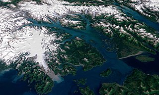
- The water in the foreground in the southwest (bottom left) corner of the image is the Gulf of Alaska, with Icy Strait running roughly west to east (horizontally) in from Cape Spencer where the strait meets the Pacific. The foreground glacier is the Brady Glacier. The light gray feature at the foot of the glacier is fine silt dropped by the glacier as it melts. The glacier’s meltwater washes the silt into the Strait, coloring the shallow waters light blue as the silt mixes. The long finger of water dominating the entire scene is Glacier Bay itself. The two points of land at the beginning of the Bay are roughly where the Grand Pacific Glacier ended when George Vancouver’s crew surveyed the area. The Grand Pacific Glacier now terminates well above Tar Inlet, the finger of water stretching furthermost north (up) at the top of Glacier Bay. The first major inlet on the east (right) coming up from the mouth of Glacier Bay is Muir Inlet. The glaciers feeding into the bay terminated here around 1860. The body of water paralleling the Bay on the eastern edge is Lynn Canal, a body of water also draining into Icy Strait beyond the eastern boundary of the park.
- The image above is a visualization created by merging imagery from the Landsat 7 satellite’s Enhanced Thematic Mapper Plus (ETM+) instrument with elevation data from the USGS National Elevation Dataset (NED). This true-color image was created by combining the red, green, and blue wavelengths (ETM+ bands 3, 2, and 1). The resulting image was then draped over a visualization of the NED data with no vertical exaggeration. The USGS NED is a merged data product created from from several sources, prodominately 30-meter resolution elevation data collected by NASA’s Shuttle Radar Topography Mission (SRTM).
Ліцензування
| Цей файл перебуває у суспільному надбанні, оскільки він був створений NASA (Національним управлінням з аеронавтики і дослідження космічного простору). Згідно з політикою NASA стосовно авторського права, «матеріали NASA не захищаються авторським правом, якщо не вказано протилежне». (Див. Template:PD-USGov, сторінку політики NASA стосовно авторського права, або політику використання зображень JPL.) | ||
 |
Попередження:
|
Історія файлу
Клацніть на дату/час, щоб переглянути, як тоді виглядав файл.
| Дата/час | Мініатюра | Розмір об'єкта | Користувач | Коментар | |
|---|---|---|---|---|---|
| поточний | 02:41, 11 вересня 2006 | | 7500 × 4500 (4,04 МБ) | Davepape | {{Information |Description=3D visualization of Landsat imagery of Glacier Bay National Park and Preserve |Source=Visible Earth - http://visibleearth.nasa.gov/view_rec.php?id=16657 |Date= 2003-12-07 |Author= Lan |
Використання файлу
Така сторінка використовує цей файл:
Глобальне використання файлу
Цей файл використовують такі інші вікі:
- Використання в ar.wikipedia.org
- Використання в ceb.wikipedia.org
- Використання в cs.wikipedia.org
- Використання в de.wikipedia.org
- Використання в en.wikipedia.org
- Використання в eo.wikipedia.org
- Використання в es.wikipedia.org
- Використання в fr.wikipedia.org
- Використання в he.wikipedia.org
- Використання в hr.wikipedia.org
- Використання в it.wikipedia.org
- Використання в ja.wikipedia.org
- Використання в pt.wikipedia.org
- Використання в ru.wikipedia.org
- Використання в sr.wikipedia.org
- Використання в sv.wikipedia.org
- Використання в tr.wikipedia.org
- Використання в uz.wikipedia.org
- Використання в vec.wikipedia.org
- Використання в www.wikidata.org