Файл:Mars Viking MDIM21 1km plus poles.jpg

Повна роздільність (26 674 × 10 670 пікселів, розмір файлу: 46,26 МБ, MIME-тип: image/jpeg)
| Відомості про цей файл містяться на Вікісховищі — централізованому сховищі вільних файлів мультимедіа для використання у проектах Фонду Вікімедіа. |
| Попередження | У деяких браузерах можуть виникнути проблеми при перегляді цього зображення у повній роздільності: це зображення має дуже велику кількість пікселів і може завантажитись зі спотвореннями, або спричинити зависання браузера. |
|---|
Опис файлу
| Опис |
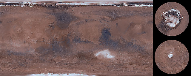
English: This global image map of Mars has a resolution of approximately 1.0 km/pixel at the equator. It is a reduced version of a much larger map with 231 m/pixel resolution at the equator. The colorized mosaic was completed by NASA Ames which warped the original Viking colorized mosaic and blended over the latest black/white mosaic. The full resolution mosaic is known as Colorized Mars Digital Image Model (MDIM) 2.1. MDIM 2.1 replaces two earlier mosaics produced by the USGS from the same set of approximately 4600 Viking Orbiter images. The positional accuracy of features in MDIM 2.1 is estimated to be roughly one pixel (200 m), compared to 3 km for MDIM 2.0 released in 2001 and >6 km for MDIM 1.0 released in 1991. In addition to relatively imprecise geodetic control, the previous mosaics were affected by changing definitions of cartographic parameters (such as the definition of zero longitude), resulting in an overall longitude shift of as much as 0.2° between the early MDIMs and other datasets. The new mosaic uses the most recent coordinate system definitions for Mars. These definitions have been widely adopted by NASA missions and other users of planetary data and are likely to remain in use for a decade or more. As a result, MDIM 2.1 not only registers precisely with data from current missions, such as MGS and 2001 Mars Odyssey, but will serve as an accurate basemap on which data from future missions can be plotted. The images used to make MDIM 2.1 were obtained primarily through the red, clear, and minus-blue filters of the Viking Orbiter imaging system, and thus provide a monochromatic view of Mars weighted toward the red end of the visible spectrum. Images were obtained with a wide range of solar incidence angles. It is unfortunately not possible to correct the appearance of both albedo (reflectivity) variations and topographic features for these incidence angle variations simultaneously. The images have therefore been highpass-filtered at a scale of ~50 km to remove regional albedo variations and then normalized so that equal topographic slopes appear with equal contrast everywhere. Photometric processing for MDIM 2.1 incorporates a model of the transmission and scattering of light in the atmosphere that is substantially improved over that used in MDIM 2.0. Residual tonal mismatches between different images after photometric correction were corrected based on a least-squares adjustment of image brightness and contrast. Because of these photometric and cosmetic improvements, it was possible to use a less severe highpass filter than for MDIM 2.0, improving the overall appearance of the mosaic. The original USGS polar mosaics were increased in size by a linear factor of 1.6 and given margins before being appended to the USGS global mosaic. |
| Час створення | |
| Джерело | https://astrogeology.usgs.gov/search/details/Mars/Viking/MDIM21/Mars_Viking_MDIM21_ClrMosaic_global_232m/cub |
| Автор | NASA / Jet Propulsion Lab / USGS |
| Інші версії |
|


Ліцензування
Ця робота перебуває в суспільному надбанні в США, оскільки вона є роботою Федерального уряду Сполучених Штатів Америки відповідно до розділу 17, параграфу 1, статті 105 Кодексу США (див. Авторське право).
Увага: Це стосується лише робіт Федерального Уряду США, а не робіт окремих штатів, територій, співдружностей, округів, міст, чи інших територіальних одиниць (див. шаблони-ліцензії штатів). Цей шаблон також не може бути використаний для поштових марок Поштової служби США випущених з 1978 року (див. § 313.6(C)(1) Збірки досвіду з авторського права США). Також це стосується деяких монет США (див. Правила Монетного двору США).
|
 | |
| Цей файл визнано вільним від відомих обмежень з боку закону про авторські права, включаючи всі пов'язані і суміжні права. | ||
Історія файлу
Клацніть на дату/час, щоб переглянути, як тоді виглядав файл.
| Дата/час | Мініатюра | Розмір об'єкта | Користувач | Коментар | |
|---|---|---|---|---|---|
| поточний | 06:30, 14 березня 2014 | 26 674 × 10 670 (46,26 МБ) | WolfmanSF | User created page with UploadWizard |
Використання файлу
Така сторінка використовує цей файл:
Глобальне використання файлу
Цей файл використовують такі інші вікі:
- Використання в ar.wikipedia.org
- Використання в el.wikipedia.org
- Використання в en.wikipedia.org
- Використання в fa.wikipedia.org
- Використання в hr.wikipedia.org
- Використання в vi.wikipedia.org