Файл:Okavango Delta map.png

Повна роздільність (1860 × 1916 пікселів, розмір файлу: 733 КБ, MIME-тип: image/png)
| Відомості про цей файл містяться на Вікісховищі — централізованому сховищі вільних файлів мультимедіа для використання у проектах Фонду Вікімедіа. |
| Опис |
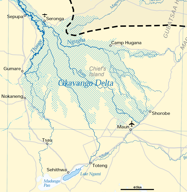
Deutsch: Karte des Okawangodeltas (vergrößerter Ausschnitt aus Datei Okavango River Basin map.png). Detaillierte Kartenlegende siehe dort.
English: Map of the Okavango delta (Botswana), expanded part of File:Okavango River Basin map.png. For detailled map legend see there.
|
| Час створення | |
| Джерело | http://www.un.org/Depts/Cartographic/map/profile/okavango.pdf (part) |
| Автор | United Nations |
| Ліцензія (Повторне використання цього файлу) |
UN map as PD |
| Інші версії |
 |
| This image is a map derived from a United Nations map.
Unless stated otherwise, UN maps are to be considered in the public domain. This applies worldwide. UN maps are, in principle, open source material and you can use them in your work or for making your own map. UN requests however that you delete the UN name, logo and reference number upon any modification to the map. Content of your map will be your responsibility. You can state in your publication, if you wish, something like: based on UN map … (map name, map number, revision number and date). See: Geospatial Information Section. And: Geospatial, location data for a better world. |
 |
Історія файлу
Клацніть на дату/час, щоб переглянути, як тоді виглядав файл.
| Дата/час | Мініатюра | Розмір об'єкта | Користувач | Коментар | |
|---|---|---|---|---|---|
| поточний | 17:54, 27 червня 2018 | | 1860 × 1916 (733 КБ) | Antonsusi | adding a scale |
| 06:45, 5 квітня 2016 |  | 1860 × 1916 (427 КБ) | RokerHRO | optipng -zc1-9 -zm1-9 -zs0-3 -f0-5 -i0 → 41.70% decrease | |
| 12:55, 17 березня 2012 |  | 1860 × 1916 (733 КБ) | Antonsusi | {{UN map}} |
Використання файлу
Такі сторінки використовують цей файл:
Глобальне використання файлу
Цей файл використовують такі інші вікі:
- Використання в af.wikipedia.org
- Використання в ar.wikipedia.org
- Використання в avk.wikipedia.org
- Використання в az.wikipedia.org
- Використання в bh.wikipedia.org
- Використання в bn.wikipedia.org
- Використання в ca.wikipedia.org
- Використання в cs.wikipedia.org
- Використання в da.wikipedia.org
- Використання в de.wikipedia.org
- Використання в en.wikipedia.org
- Використання в eo.wikipedia.org
- Використання в es.wikipedia.org
- Використання в et.wikipedia.org
- Використання в fi.wikipedia.org
- Використання в fr.wikipedia.org
- Використання в hr.wikipedia.org
- Використання в incubator.wikimedia.org
- Використання в ka.wikipedia.org
- Використання в ml.wikipedia.org
- Використання в mt.wikipedia.org
- Використання в nl.wikipedia.org
- Використання в pl.wikipedia.org
- Використання в pt.wikipedia.org
- Використання в ru.wikipedia.org
- Використання в sh.wikipedia.org
- Використання в sk.wikipedia.org
- Використання в sl.wikipedia.org
- Використання в sv.wikipedia.org
- Використання в ta.wikipedia.org
- Використання в tr.wikipedia.org
- Використання в vi.wikipedia.org
- Використання в xmf.wikipedia.org
- Використання в zh.wikipedia.org