Файл:Ortelius’ map of the Black Sea.jpg
Повна роздільність (2161 × 1600 пікселів, розмір файлу: 4,76 МБ, MIME-тип: image/jpeg)
| Відомості про цей файл містяться на Вікісховищі — централізованому сховищі вільних файлів мультимедіа для використання у проектах Фонду Вікімедіа. |
Опис файлу
| Опис |
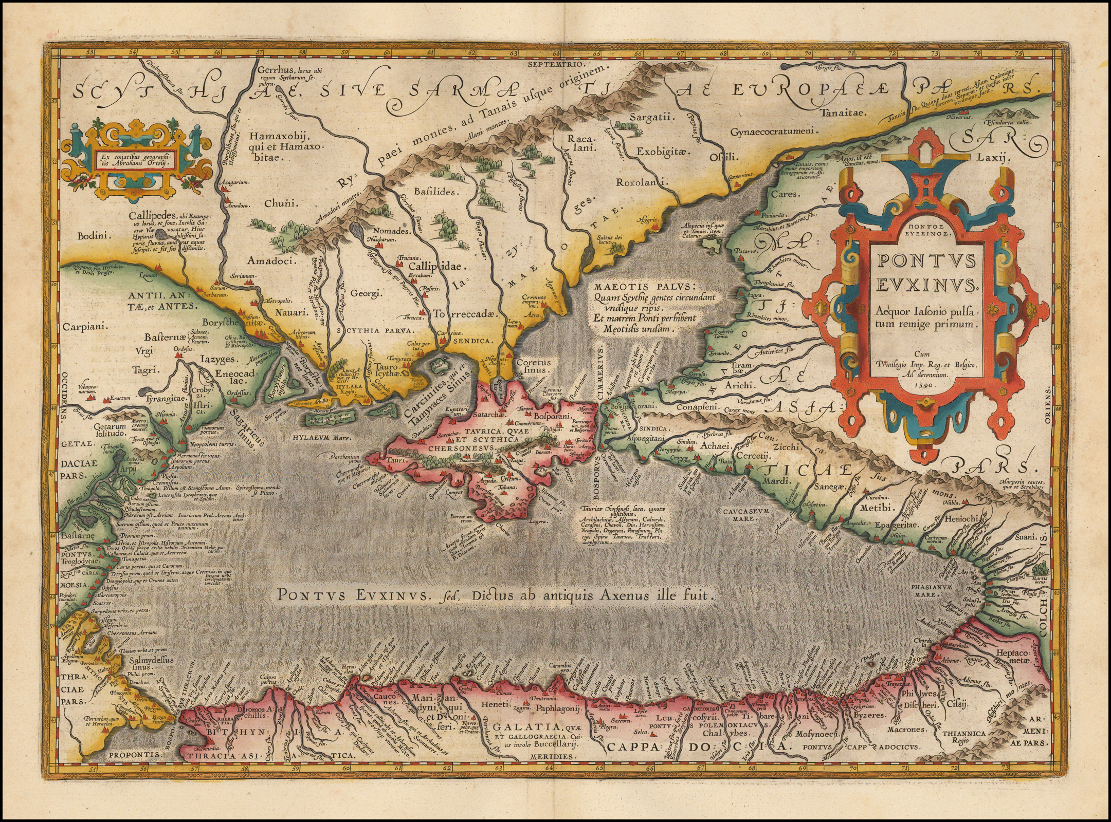
Українська: Ortelius’ map of the Black Sea.
English: Ortelius’ map of the Black Sea, published in his 1624 edition of the Parergon, an atlas depicting the ancient world. The Parergon was generally published as an appendix to Ortelius’ magnum opus, the Theatrum Orbis Terrarum, which is considered the first modern atlas. However, the Parergon was also published as a separate atlas on a few occasions, including in 1624.
The map is oriented northward, with the directions carefully noted in the center of each edge of the map. The entirety of the Black Sea is displayed, as well as the surrounding regions, including present-day Turkey and Armenia (Bithynia, Galatia, Cappadocia, Armeniae Pars), Georgia and Russia (Colchis, Sarmatiae Asiaticae pars), Ukraine (Scythiae sive sarmatiae Europaeæpa), the Crimean peninsula (Taurica quae et scythica chersonesus), Moldova, Romania, and Bulgaria (Getae, Daciae pars, Pontus Moesia), and Greece (Thraciae pars). The smaller water body connected to the Black Sea to the north is Maeotis Palus (the Maeotis Swamp or Lake Maeotis), which is today known as the Sea of Azov. The sea is colored an appropriate dark grey while the other regions are differentiated by color, alternating between red, green, and yellow. This map is characterized by excellent attention to detail. The shape of the coastlines and rivers are carefully rendered, and throughout the map mountain ranges and forests give the land texture. Cities are represented with unique drawings in dark red. Each aspect of the map is labeled, and some labels give additional information about the name or events that occurred there. This indicates the map’s use as a reference for the region in both geography and history. The two cartouches, one containing the title and date and the other the map’s creator, are sharply rendered and brightly colored in red, blue, and yellow. The ornamented edges curl out and are shaded so as to give them a three-dimensional quality that pops from the page. In particular, the decorative title cartouche takes up a large part of the land on the eastern area of the map. The title of the map, Pontus Euxinus, is Latin for “hospitable sea,” a euphemism for the earlier name “inhospitable sea,” as the Black Sea was known for its stormy weather, harsh currents, and lack of islands to visit. Also found in the cartouche is the phrase “Aequor Iasonio pulsatum remige primum,” indicating that this was the sea first traveled by Jason, the ancient Greek hero who sailed to find the Golden Fleece. This places the map firmly in the realm of classical mythology. The map includes many interesting locations important to Greek mythology. Phryxis’ temple is located on the Phasis river in Colchis (in the southeast corner of the map), which was the location of the Golden Fleece, the object of Jason’s quest. Themiscyra, home to the Amazons and a city visited by Heracles during his Nine Labours, is also present on the southern shore of the Black Sea, between the Iris and Thermodon rivers. There are also numerous cities named for Greek gods and heroes, such as Apollonia Magna on the Thracian coast and Heraclea near the mouth of the Acheron river in Bithynia. •Barry Lawrence Ruderman• |
|||||||||||||||||||||||
| Час створення | 1590, published in 1624. | |||||||||||||||||||||||
| Джерело |
https://storage.googleapis.com/raremaps/img/xlarge/50869.jpg https://i.pinimg.com/originals/01/b5/34/01b534a7d1cc53cdd5f7e918177a4d8b.jpg |
|||||||||||||||||||||||
| Автор |
|
|||||||||||||||||||||||
| Інші версії | ||||||||||||||||||||||||


Ліцензування
|
Ця робота перебуває у суспільному надбанні у країнах і територіях, де авторське право охороняється протягом життя автора та 70 років після того або менше. Ця робота перебуває у суспільному надбанні у Сполучених Штатах, оскільки вона була опублікована (або зареєстрована у U.S. Copyright Office) до 1 січня 1929 року. | |
| Цей файл визнано вільним від відомих обмежень з боку закону про авторські права, включаючи всі пов'язані і суміжні права. | |
Історія файлу
Клацніть на дату/час, щоб переглянути, як тоді виглядав файл.
| Дата/час | Мініатюра | Розмір об'єкта | Користувач | Коментар | |
|---|---|---|---|---|---|
| поточний | 08:45, 5 жовтня 2019 | | 2161 × 1600 (4,76 МБ) | Poli.Pav | User created page with UploadWizard |
Використання файлу
Такі сторінки використовують цей файл: