Файл:PIA18822-LunarGrailMission-OceanusProcellarum-Rifts-Overall-20141001.jpg

Повна роздільність (1500 × 1500 пікселів, розмір файлу: 199 КБ, MIME-тип: image/jpeg)
| Відомості про цей файл містяться на Вікісховищі — централізованому сховищі вільних файлів мультимедіа для використання у проектах Фонду Вікімедіа. |
Опис файлу
| Опис |
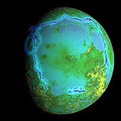
English: PIA18822: Gravity Gradients Frame Oceanus Procellarum
October 1, 2014 http://photojournal.jpl.nasa.gov/catalog/PIA18822 Topography of Earth's moon generated from data collected by the Lunar Orbiter Laser Altimeter, aboard NASA's Lunar Reconnaissance Orbiter, with the gravity anomalies bordering the Procellarum region superimposed in blue. The border structures are shown using gravity gradients calculated with data from NASA's Gravity Recovery and Interior Laboratory (GRAIL) mission. These gravity anomalies are interpreted as ancient lava-flooded rift zones buried beneath the volcanic plains (or maria) on the nearside of the Moon. Launched as GRAIL A and GRAIL B in September 2011, the probes, renamed Ebb and Flow, operated in a nearly circular orbit near the poles of the moon at an altitude of about 34 miles (55 kilometers) until their mission ended in December 2012. The distance between the twin probes changed slightly as they flew over areas of greater and lesser gravity caused by visible features, such as mountains and craters, and by masses hidden beneath the lunar surface. The twin spacecraft flew in a nearly circular orbit until the end of the mission on Dec. 17, 2012, when the probes intentionally were sent into the moon's surface. NASA later named the impact site in honor of late astronaut Sally K. Ride, who was America's first woman in space and a member of the GRAIL mission team. GRAIL's prime and extended science missions generated the highest-resolution gravity field map of any celestial body. The map will provide a better understanding of how Earth and other rocky planets in the solar system formed and evolved. The GRAIL mission was managed by NASA's Jet Propulsion Laboratory (JPL) in Pasadena, California, for NASA's Science Mission Directorate in Washington. The mission was part of the Discovery Program managed at NASA's Marshall Space Flight Center in Huntsville, Alabama. GRAIL was built by Lockheed Martin Space Systems in Denver. For more information about GRAIL, please visit http://grail.nasa.gov. |
| Час створення | |
| Джерело | http://photojournal.jpl.nasa.gov/jpeg/PIA18822.jpg |
| Автор | NASA/Colorado School of Mines/MIT/GSFC/Scientific Visualization Studio |
Ліцензування
| Цей файл перебуває у суспільному надбанні, оскільки він був створений NASA (Національним управлінням з аеронавтики і дослідження космічного простору). Згідно з політикою NASA стосовно авторського права, «матеріали NASA не захищаються авторським правом, якщо не вказано протилежне». (Див. Template:PD-USGov, сторінку політики NASA стосовно авторського права, або політику використання зображень JPL.) | ||
 |
Попередження:
|
Історія файлу
Клацніть на дату/час, щоб переглянути, як тоді виглядав файл.
| Дата/час | Мініатюра | Розмір об'єкта | Користувач | Коментар | |
|---|---|---|---|---|---|
| поточний | 02:30, 5 жовтня 2014 | | 1500 × 1500 (199 КБ) | Drbogdan | User created page with UploadWizard |
Використання файлу
Така сторінка використовує цей файл:
Глобальне використання файлу
Цей файл використовують такі інші вікі:
- Використання в ar.wikipedia.org
- Використання в bn.wikipedia.org
- Використання в ca.wikipedia.org
- Використання в de.wikipedia.org
- Використання в en.wikipedia.org
- Використання в es.wikipedia.org
- Використання в fa.wikipedia.org
- Використання в fr.wikipedia.org
- Використання в hy.wikipedia.org
- Використання в id.wikipedia.org
- Використання в ko.wikipedia.org
- Використання в mk.wikipedia.org
- Використання в mnw.wikipedia.org
- Використання в pt.wikipedia.org
- Використання в ro.wikipedia.org
- Використання в sl.wikipedia.org
- Використання в ta.wikipedia.org
- Використання в test.wikipedia.org
- Використання в tr.wikipedia.org
- Використання в vi.wikipedia.org
- Використання в zh.wikipedia.org
Переглянути сторінку глобального використання цього файлу.