Файл:1831 Hooker Map of New York City (1871 reissue) - Geographicus - NewYork-hooker-1871.jpg
Перейти до навігації
Перейти до пошуку

Розмір при попередньому перегляді: 478 × 600 пікселів. Інші роздільності: 191 × 240 пікселів | 383 × 480 пікселів | 612 × 768 пікселів | 816 × 1024 пікселів | 1633 × 2048 пікселів | 3000 × 3763 пікселів.
Повна роздільність (3000 × 3763 пікселів, розмір файлу: 2,6 МБ, MIME-тип: image/jpeg)
| Відомості про цей файл містяться на Вікісховищі — централізованому сховищі вільних файлів мультимедіа для використання у проектах Фонду Вікімедіа. |
Опис файлу
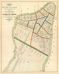
| William Hooker: Map of the City of New-York Compiled & Surveyed by William Hooker.
( |
||||||||||||||
|---|---|---|---|---|---|---|---|---|---|---|---|---|---|---|
| Митець |
|
|||||||||||||
| Заголовок |
Map of the City of New-York Compiled & Surveyed by William Hooker. |
|||||||||||||
| Опис |
English: This is an unusual map of New York City first issued in 1831 by William Hooker and Peabody. This example is a reissue, apparently from the same plate, dating to the Hardy edition of the Manual of the Corporation of New York , 1871. Perhaps this map’s most striking feature is the fact that the orientation of the map and the orientation of the title are at odds. We have stumbled across this piece a few times from both the first and second issues, and all examples exhibit the same conflicting orientation. Since this map was originally published to supplement a book of pictures and views of New York and vicinity by T.S. Fay, we can speculate that the limited budget of the publisher, Peabody and Company, made a reissue of the map impractical despite the orientation error. Cartographically this map claims to be the culmination of original survey work accomplished by William Hooker, but to our eye is a clear copy of Burr’s contemporaneous pocket map of New York City. Hooker’s map, like Burr’s names all streets and identifies city wards from the Battery to 52nd Street. Important buildings, docks, topographical features, and parks are noted. Though originally issued in 1831 for T.S. Fay’s Views in the City of New-York and its Environs , this example is a reissue prepared by John Hardy, Clerk of the Common Council, for the 1871 edition of the Manual of the Corporation of New York . |
|||||||||||||
| Час створення | 1831 (1871 reissue) | |||||||||||||
| Розміри | висота: 16 дюймів (40,6 см); ширина: 12,5 дюймів (31,7 см) | |||||||||||||
| Інвентарний номер |
Geographicus link: NewYork-hooker-1871 |
|||||||||||||
| Джерело/Фотограф |
Hardy, John , ed. (1870) Manual of the Corporation of the City of New York, Нью-Йорк: Common Council, before p. 905 [aka Valentine's Manual (1870)]. Also in: Fay, T. S., Views in the City of New-York and its Environs, 1831.
|
|||||||||||||
| Ліцензія (Повторне використання цього файлу) |
|
|||||||||||||
| Інші версії |
 |
|||||||||||||


_-_Geographicus_-_NewYork-hooker-1871.jpg)
Історія файлу
Клацніть на дату/час, щоб переглянути, як тоді виглядав файл.
| Дата/час | Мініатюра | Розмір об'єкта | Користувач | Коментар | |
|---|---|---|---|---|---|
| поточний | 23:04, 24 березня 2011 | | 3000 × 3763 (2,6 МБ) | BotMultichillT | {{subst:User:Multichill/Geographicus |link=http://www.geographicus.com/P/AntiqueMap/NewYork-hooker-1871 |product_name=1831 Hooker Map of New York City (1871 reissue) |map_title=Map of the City of New-York Compiled & Surveyed by William Hooker. |descriptio |
Використання файлу
Такі сторінки використовують цей файл:
Глобальне використання файлу
Цей файл використовують такі інші вікі:
- Використання в en.wikipedia.org
- Використання в ru.wikipedia.org
_-_Geographicus_-_NewYork-hooker-1871.jpg)