Файл:Americas satellite map.jpg

Повна роздільність (2300 × 2900 пікселів, розмір файлу: 1,87 МБ, MIME-тип: image/jpeg)
| Відомості про цей файл містяться на Вікісховищі — централізованому сховищі вільних файлів мультимедіа для використання у проектах Фонду Вікімедіа. |
Опис файлу
| Опис |
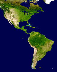
NASA's description of the original non-cropped imageː "This spectacular “blue marble” image is the most detailed true-color image of the entire Earth to date. Using a collection of satellite-based observations, scientists and visualizers stitched together months of observations of the land surface, oceans, sea ice, and clouds into a seamless, true-color mosaic of every square kilometer (.386 square mile) of our planet. These images are freely available to educators, scientists, museums, and the public. This record includes preview images and links to full resolution versions up to 21,600 pixels across. Much of the information contained in this image came from a single remote-sensing device-NASA’s Moderate Resolution Imaging Spectroradiometer, or MODIS. Flying over 700 km above the Earth onboard the Terra satellite, MODIS provides an integrated tool for observing a variety of terrestrial, oceanic, and atmospheric features of the Earth. The land and coastal ocean portions of these images are based on surface observations collected from June through September 2001 and combined, or composited, every eight days to compensate for clouds that might block the sensor’s view of the surface on any single day. Two different types of ocean data were used in these images: shallow water true color data, and global ocean color (or chlorophyll) data. Topographic shading is based on the GTOPO 30 elevation dataset compiled by the U.S. Geological Survey’s EROS Data Center. MODIS observations of polar sea ice were combined with observations of Antarctica made by the National Oceanic and Atmospheric Administration’s AVHRR sensor—the Advanced Very High Resolution Radiometer. The cloud image is a composite of two days of imagery collected in visible light wavelengths and a third day of thermal infra-red imagery over the poles. Global city lights, derived from 9 months of observations from the Defense Meteorological Satellite Program, are superimposed on a darkened land surface map." The 8192 x 4096 TIFF NASA global map has been cropped, adjusted in brightness, and converted to JPEG. |
| Час створення | |
| Джерело | http://visibleearth.nasa.gov/view_rec.php?id=2433 |
| Автор | NASA |
| Інші версії | Похідні роботи від цього файлу: Distribution of P. peckolti.jpg |
Ліцензування
| Цей файл перебуває у суспільному надбанні, оскільки він був створений NASA (Національним управлінням з аеронавтики і дослідження космічного простору). Згідно з політикою NASA стосовно авторського права, «матеріали NASA не захищаються авторським правом, якщо не вказано протилежне». (Див. Template:PD-USGov, сторінку політики NASA стосовно авторського права, або політику використання зображень JPL.) | ||
 |
Попередження:
|
Історія файлу
Клацніть на дату/час, щоб переглянути, як тоді виглядав файл.
| Дата/час | Мініатюра | Розмір об'єкта | Користувач | Коментар | |
|---|---|---|---|---|---|
| поточний | 17:23, 28 червня 2008 | | 2300 × 2900 (1,87 МБ) | WolfmanSF | {{Information |Description=This spectacular “blue marble” image is the most detailed true-color image of the entire Earth to date. Using a collection of satellite-based observations, scientists and visualizers stitched together months of observations |
| 19:54, 30 грудня 2007 |  | 2300 × 2900 (1,93 МБ) | WolfmanSF | {{Information |Description=This spectacular “blue marble” image is the most detailed true-color image of the entire Earth to date. Using a collection of satellite-based observations, scientists and visualizers stitched together months of observations |
Використання файлу
Така сторінка використовує цей файл:
Глобальне використання файлу
Цей файл використовують такі інші вікі:
- Використання в ar.wikipedia.org
- Використання в bn.wikipedia.org
- Використання в ca.wikipedia.org
- Використання в ca.wikiquote.org
- Використання в ckb.wikipedia.org
- Використання в en.wikipedia.org
- Використання в es.wikipedia.org
- América del Norte
- Colombia
- Haití
- Dominica
- Portal:Geografía/Titular
- Comando Sur de Estados Unidos
- Portal:América
- Policía Nacional de la República Dominicana
- Wikiproyecto:América del Sur/Proyectos hermanos
- Anexo:Supercentenarios latinoamericanos
- Categoría:Elecciones en América en 1993
- Categoría:Elecciones en América en 1913
- Categoría:Elecciones en América en 1992
- Categoría:Elecciones en América en 1996
- Categoría:Elecciones en América en 1995
- Categoría:Elecciones en América en 1997
- Categoría:Elecciones en América en 1994
- Categoría:Elecciones en América en 1965
- Categoría:Elecciones en América en 1960
- Anexo:Imperios americanos
- Categoría:Elecciones en América en 1991
- Categoría:Elecciones en América en 1990
- Categoría:Elecciones en América en 1989
- Categoría:Elecciones en América en 1988
- Categoría:Elecciones en América en 1987
- Categoría:Elecciones en América en 1985
- Categoría:Elecciones en América en 1984
- Categoría:Elecciones en América en 1983
- Categoría:Elecciones en América en 1915
- Categoría:Elecciones en América en 1937
- Використання в es.wikivoyage.org
- Використання в eu.wikipedia.org
- Використання в fa.wikipedia.org
- Використання в ff.wikipedia.org
Переглянути сторінку глобального використання цього файлу.