Файл:Austria satellite-map.jpg

Повна роздільність (2550 × 1381 пікселів, розмір файлу: 1,22 МБ, MIME-тип: image/jpeg)
| Відомості про цей файл містяться на Вікісховищі — централізованому сховищі вільних файлів мультимедіа для використання у проектах Фонду Вікімедіа. |
Опис файлу
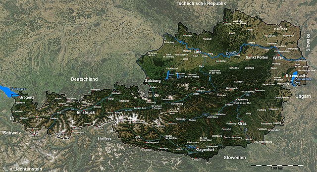
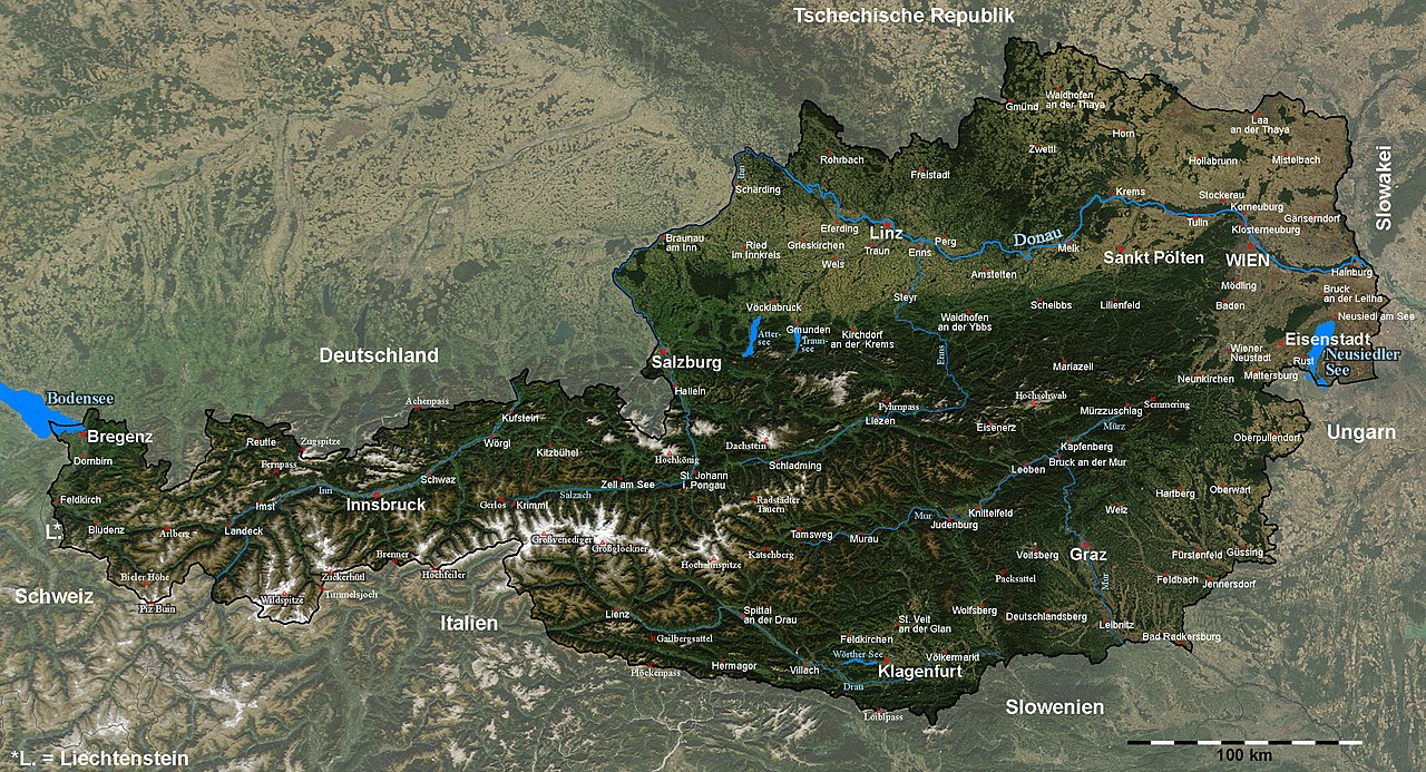
| Опис | Satellite image of Austria with provincial capitals and other annotations |
| Час створення | |
| Джерело |
The image is based on a satellite image from [1]. Original image: Credit Jeff Schmaltz, MODIS Rapid Response Team, NASA/GSFC. |
| Автор | Michael Schmid |
| Ліцензія (Повторне використання цього файлу) |
Based on a NASA image, thus in the public domain. |
| Інші версії | Image:Austria_satellite_unannotated.jpg with no annotations except dots at the positions of a few cities, Image:Austria_satellite_annotated.jpg with some limited annotations. |
![[1]](http://visibleearth.nasa.gov/images/5947/Italy.A2003262.1005.250m.jpg)
I have marked and labelled quite a lot of places with the help of the NASA Worldwind software and several maps. It was quite some work, but also a nice exercise in geography for me ;-).
Unless I have forgotten something, the map shows (among other cities) the capitals of all districts and provinces of Austria.
Please note: The cities of Wien (Vienna) and Linz were marked a few kilometers from their actual locations in the original satellite image; this has been corrected here.[2].
Das Bild wurde in y-Richtung um ca. 5% gestreckt, um eine wenig verzerrte Karte zu erhalten. Um Österreich hervorzuheben, habe ich den Kontrast außerhalb der Grenzen Österreichs reduziert und die Grenzlinie dicker eingezeichnet, und danach durch Vergleich mit der NASA Worldwind Software und diversen Karten die Positionen diverser Orte, Berge und Pässe bestimmt und eingezeichnet.
Die Karte enthält (wenn ich keine vergessen habe) unter anderem alle Landes- und Bezirkshauptstädte Österreichs.Ліцензування
| Цей файл перебуває у суспільному надбанні, оскільки він був створений NASA (Національним управлінням з аеронавтики і дослідження космічного простору). Згідно з політикою NASA стосовно авторського права, «матеріали NASA не захищаються авторським правом, якщо не вказано протилежне». (Див. Template:PD-USGov, сторінку політики NASA стосовно авторського права, або політику використання зображень JPL.) | ||
 |
Попередження:
|
Історія файлу
Клацніть на дату/час, щоб переглянути, як тоді виглядав файл.
| Дата/час | Мініатюра | Розмір об'єкта | Користувач | Коментар | |
|---|---|---|---|---|---|
| поточний | 19:41, 11 вересня 2005 | | 2550 × 1381 (1,22 МБ) | Schmid | {{Information| |Description = Satellite image of Austria with provincial capitals and other annotations | Source = The image is based on a satellite image from [http://visibleearth.nasa.gov/images/5947/Italy.A2003262.1005.250m.jpg]. Original image: Cre |
Використання файлу
Така сторінка використовує цей файл:
Глобальне використання файлу
Цей файл використовують такі інші вікі:
- Використання в af.wikipedia.org
- Використання в cs.wikipedia.org
- Використання в da.wikipedia.org
- Використання в de.wikipedia.org
- Використання в en.wikipedia.org
- Використання в fr.wikipedia.org
- Використання в hu.wikipedia.org
- Використання в hy.wikipedia.org
- Використання в hyw.wikipedia.org
- Використання в ku.wikipedia.org
- Використання в nn.wikipedia.org
- Використання в no.wikipedia.org
- Використання в rm.wikipedia.org
- Використання в ru.wikipedia.org
- Використання в sk.wikipedia.org
- Використання в tl.wikipedia.org
- Використання в tr.wikipedia.org