Файл:Dampier Mosquito.gif
Dampier_Mosquito.gif (500 × 375 пікселів, розмір файлу: 14 КБ, MIME-тип: image/gif)
| Відомості про цей файл містяться на Вікісховищі — централізованому сховищі вільних файлів мультимедіа для використання у проектах Фонду Вікімедіа. |
| Опис |
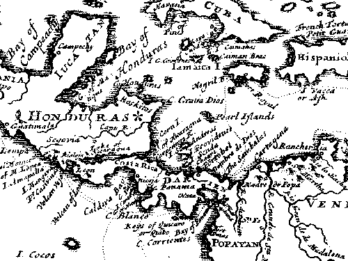
English: This map is from "A New Voyage Round the World", published in 1697 by William Dampier, the English sea captain, naturalist, and occasional pirate.
The Miskito coast is marked with a star. Dampier and his associate, the surgeon Lionel Wafer describe the Miskito peoples in the period 1690-1700. These tribal groups, often mixed with runaway slaves, formed a distinct culture in the coastal region, sometimes forming alliances with pirates against Spanish authorities in the 16th-18th centuries. |
| Джерело | |
| Автор |
Ліцензування
|
Ця робота перебуває у суспільному надбанні у країнах і територіях, де авторське право охороняється протягом життя автора та 70 років після того або менше.
| |
| Цей файл визнано вільним від відомих обмежень з боку закону про авторські права, включаючи всі пов'язані і суміжні права. | |
Журнал завантажень локального файлу
All following user names refer to en.wikipedia.
- 2007-06-29 02:41 Victor falk 500×375× (13914 bytes) This map is from "A New Voyage Round the World", published in 1697 by William Dampier, the English sea captain, naturalist, and occasional pirate. The Miskito coast is marked with a star. Dampier and his associate, the surgeon Lionel Wafer describe the
Історія файлу
Клацніть на дату/час, щоб переглянути, як тоді виглядав файл.
| Дата/час | Мініатюра | Розмір об'єкта | Користувач | Коментар | |
|---|---|---|---|---|---|
| поточний | 09:42, 16 жовтня 2009 | | 500 × 375 (14 КБ) | Urdangaray | {{Information |Description={{en|This map is from "A New Voyage Round the World", published in 1697 by William Dampier, the English sea captain, naturalist, and occasional pirate. The Miskito coast is marked with a star. Dampier and his associate, the su |
Використання файлу
Така сторінка використовує цей файл:
Глобальне використання файлу
Цей файл використовують такі інші вікі:
- Використання в az.wikipedia.org
- Використання в en.wikipedia.org
- Використання в es.wikipedia.org
- Використання в gl.wikipedia.org
- Використання в he.wikipedia.org
- Використання в id.wikipedia.org
- Використання в tr.wikipedia.org
- Використання в zh.wikipedia.org