Файл:Dao Niger and Harmakhis Vallis PIA02810.jpg
Перейти до навігації
Перейти до пошуку

Розмір при попередньому перегляді: 800 × 519 пікселів. Інші роздільності: 320 × 208 пікселів | 640 × 415 пікселів | 1024 × 664 пікселів | 1280 × 830 пікселів | 1637 × 1062 пікселів.
Повна роздільність (1637 × 1062 пікселів, розмір файлу: 168 КБ, MIME-тип: image/jpeg)
| Відомості про цей файл містяться на Вікісховищі — централізованому сховищі вільних файлів мультимедіа для використання у проектах Фонду Вікімедіа. |
Опис файлу
| Опис |
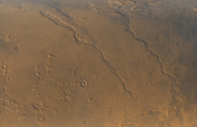
English: The Mars Global Surveyor (MGS) Mars Orbiter Camera (MOC) opened its fourth year orbiting the red planet with this mid-autumn view of three major valley systems east of the Hellas plains. From left to right, the first major valley, Dao Vallis, runs diagonally from the upper left to just past the lower center of the image. Niger Vallis joins Dao Vallis just above the center of the frame. Harmakhis Vallis extends diagonally across the right half of the picture, toward the lower right. These valleys are believed by some to have been formed--at least in part--by large outbursts of liquid water some time far back in the martian past, though there is no way to know exactly how many hundreds of millions or billions of years ago this might have occurred. In each valley, water would have flowed toward the bottom of the image. Although their dimensions vary along their courses, the valleys are all roughly 1 km (0.6 miles) deep and range in width from about 40 km (25 miles) down to about 8 km (5 mi). Located around 40°S, 270°W, the picture covers an area approximately 800 km across and is illuminated by sunlight from the lower left. North is toward the left; the picture is a composite of red and blue wide angle images obtained by MOC on September 13, 2000, |
| Джерело | http://photojournal.jpl.nasa.gov/catalog/PIA02810 |
| Автор | NASA/JPL/MSSS |
Ліцензування
| Цей файл перебуває у суспільному надбанні, оскільки він був створений NASA (Національним управлінням з аеронавтики і дослідження космічного простору). Згідно з політикою NASA стосовно авторського права, «матеріали NASA не захищаються авторським правом, якщо не вказано протилежне». (Див. Template:PD-USGov, сторінку політики NASA стосовно авторського права, або політику використання зображень JPL.) | ||
 |
Попередження:
|
Історія файлу
Клацніть на дату/час, щоб переглянути, як тоді виглядав файл.
| Дата/час | Мініатюра | Розмір об'єкта | Користувач | Коментар | |
|---|---|---|---|---|---|
| поточний | 06:55, 12 квітня 2008 | | 1637 × 1062 (168 КБ) | Bryan Derksen | {{Information |Description={{en| The Mars Global Surveyor (MGS) Mars Orbiter Camera (MOC) opened its fourth year orbiting the red planet with this mid-autumn view of three major valley systems east of the Hellas plains. From left to right, the first ma |
Використання файлу
Такі сторінки використовують цей файл:
Глобальне використання файлу
Цей файл використовують такі інші вікі:
- Використання в ca.wikipedia.org
- Використання в cs.wikipedia.org
- Використання в en.wikipedia.org
- Використання в es.wikipedia.org
- Використання в fr.wikipedia.org
- Використання в it.wikipedia.org
- Використання в ja.wikipedia.org
- Використання в pl.wikipedia.org
- Використання в pt.wikipedia.org
- Використання в www.wikidata.org
- Використання в zh.wikipedia.org