Файл:Gulf of Martaban, Myanmar ESA23385933.jpeg

Повна роздільність (10 980 × 20 861 пікселів, розмір файлу: 12,56 МБ, MIME-тип: image/jpeg)
| Відомості про цей файл містяться на Вікісховищі — централізованому сховищі вільних файлів мультимедіа для використання у проектах Фонду Вікімедіа. |
Опис файлу
| Попередження | У деяких браузерах можуть виникнути проблеми при перегляді цього зображення у повній роздільності: це зображення має дуже велику кількість пікселів і може завантажитись зі спотвореннями, або спричинити зависання браузера. |
|---|
| Опис |
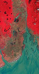
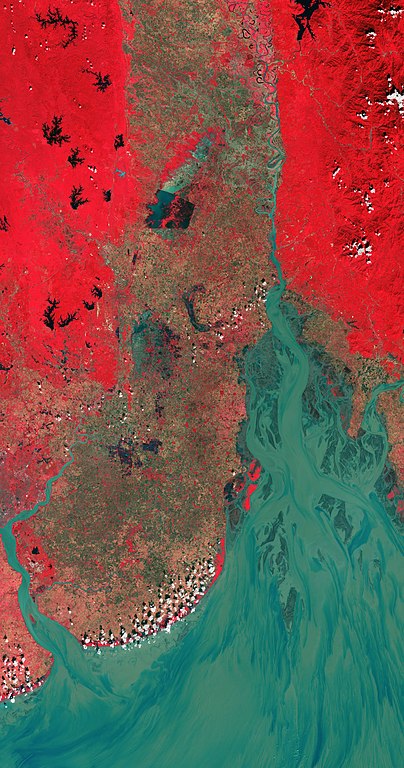
English: The Gulf of Martaban, an arm of the Andaman Sea located in southern Myanmar, is featured in this false-colour image captured by the Copernicus Sentinel-2 mission. The image has been processed in a way that included the near-infrared channel – which makes vegetation appear bright red. Zoom in to see this image at its full 10 m resolution or click on the circles to learn more about the features in it. The gulf, also known as Gulf of Mottama, is named after the port city of Mottama, formerly known as Martaban. The Gulf of Martaban is considered a unique estuarine mudflat environment that is home to a great variety of flora and fauna. Fed by sediment and nutrients from three major rivers (Sittang, Salween and Yangon), the gulf supports a number of species including marine fish, 150 000 migratory birds as well as supporting the livelihood of tens of thousands of people. A notable characteristic of the gulf is that it has a tide-dominated coastline, with tidal ranges between six and seven metres. The mouth of the gulf, which is approximately 100 km wide, narrows into a funnel-shaped bay to produce a powerful tidal bore phenomenon that can reach heights of over a metre in the upper estuary. As a result, the tidal mudflats of the gulf are among the largest in the world. The Sittang River, visible in the right side of the image, originates near Mandalay, Myanmar, and flows southward for around 420 km before emptying into the gulf. Dense vegetation can be seen in bright red, particularly in the left of the image. The distinct rectangular shape, visible in the upper half of the image, is part of the Moeyungyi Wetland Wildlife Sanctuary, a designated Ramsar Site of International Importance. The site encompasses several artificial lakes and bodies (visible in black). One of the bodies of water appears in light blue most likely owing to eutrophication – the overabundance of algae, phosphorus and other plant nutrients. The city of Yangon is visible in the bottom-left of the image, at the convergence of the Yangon and Bago Rivers. With over seven million people, Yangon is Myanmar's most populous city and its most important commercial centre. The city served as the country’s capital until 2006. Sentinel-2 is a two-satellite mission to supply the coverage and data delivery needed for Europe’s Copernicus programme. The mission’s frequent revisits over the same area and high spatial resolution allow changes in water bodies to be closely monitored. This image, acquired on 18 November 2020, is also featured on the Earth from Space video programme. |
| Час створення | 9 липня 2021 (дата завантаження) |
| Джерело | Gulf of Martaban, Myanmar |
| Автор | European Space Agency |
| Інші версії |
|
| Activity | Observing the Earth |
| Mission | Sentinel-2 |
| Set | Earth observation image of the week |
| System | Copernicus |

Ліцензування

|
This image contains data from a satellite in the Copernicus Programme, such as Sentinel-1, Sentinel-2 or Sentinel-3. Attribution is required when using this image.
Зазначення авторства: Contains modified Copernicus Sentinel data 2020
The use of Copernicus Sentinel Data is regulated under EU law (Commission Delegated Regulation (EU) No 1159/2013 and Regulation (EU) No 377/2014). Relevant excerpts:
Free access shall be given to GMES dedicated data [...] made available through GMES dissemination platforms [...].
Access to GMES dedicated data [...] shall be given for the purpose of the following use in so far as it is lawful:
GMES dedicated data [...] may be used worldwide without limitations in time.
GMES dedicated data and GMES service information are provided to users without any express or implied warranty, including as regards quality and suitability for any purpose. |
This media was created by the European Space Agency (ESA).
Where expressly so stated, images or videos are covered by the Creative Commons Attribution-ShareAlike 3.0 IGO (CC BY-SA 3.0 IGO) licence, ESA being an Intergovernmental Organisation (IGO), as defined by the CC BY-SA 3.0 IGO licence. The user is allowed under the terms and conditions of the CC BY-SA 3.0 IGO license to Reproduce, Distribute and Publicly Perform the ESA images and videos released under CC BY-SA 3.0 IGO licence and the Adaptations thereof, without further explicit permission being necessary, for as long as the user complies with the conditions and restrictions set forth in the CC BY-SA 3.0 IGO licence, these including that:
See the ESA Creative Commons copyright notice for complete information, and this article for additional details.
|
 | |
Цей файл розповсюджується під ліцензією Creative Commons Attribution-ShareAlike 3.0 IGO Зазначення авторства: ESA, CC BY-SA IGO 3.0
| ||
Історія файлу
Клацніть на дату/час, щоб переглянути, як тоді виглядав файл.
| Дата/час | Мініатюра | Розмір об'єкта | Користувач | Коментар | |
|---|---|---|---|---|---|
| поточний | 08:56, 9 липня 2021 | | 10 980 × 20 861 (12,56 МБ) | OptimusPrimeBot | #Spacemedia - Upload of https://www.esa.int/var/esa/storage/images/esa_multimedia/images/2021/07/gulf_of_martaban_myanmar/23385923-1-eng-GB/Gulf_of_Martaban_Myanmar.jpg via Commons:Spacemedia |
Використання файлу
Така сторінка використовує цей файл:
Глобальне використання файлу
Цей файл використовують такі інші вікі:
- Використання в ast.wikipedia.org
- Використання в bg.wikipedia.org
- Використання в ca.wikipedia.org
- Використання в ceb.wikipedia.org
- Використання в es.wikipedia.org
- Використання в ko.wikipedia.org
- Використання в mzn.wikipedia.org
- Використання в pl.wikipedia.org
- Використання в www.wikidata.org