Файл:Okavango River Basin map.png

Повна роздільність (3052 × 3160 пікселів, розмір файлу: 8,63 МБ, MIME-тип: image/png)
| Відомості про цей файл містяться на Вікісховищі — централізованому сховищі вільних файлів мультимедіа для використання у проектах Фонду Вікімедіа. |
Опис файлу
![]() Do not add Template:Convert to SVG, because the source is a pdf file with a pixel image, not a vector image.
Do not add Template:Convert to SVG, because the source is a pdf file with a pixel image, not a vector image.
| Опис |
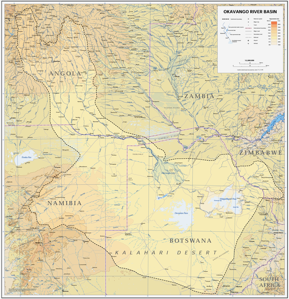
Afrikaans: Kaart van die opvangsgebied en waterskeiding (stippellyn) van die Kavangorivier in Angola, Namibië en Botswana
English: Map of the Okavango River Basin, with catchment area inside the dotted line (Angola, Namibia, Botswana) |
| Час створення | |
| Джерело | https://digitallibrary.un.org/record/423191?ln=en |
| Автор | United Nations |
| Ліцензія (Повторне використання цього файлу) |
UN map as PD |
| Інші версії |
 |
| This image is a map derived from a United Nations map.
Unless stated otherwise, UN maps are to be considered in the public domain. This applies worldwide. UN maps are, in principle, open source material and you can use them in your work or for making your own map. UN requests however that you delete the UN name, logo and reference number upon any modification to the map. Content of your map will be your responsibility. You can state in your publication, if you wish, something like: based on UN map … (map name, map number, revision number and date). See: Geospatial Information Section. And: Geospatial, location data for a better world. |
 |
Історія файлу
Клацніть на дату/час, щоб переглянути, як тоді виглядав файл.
| Дата/час | Мініатюра | Розмір об'єкта | Користувач | Коментар | |
|---|---|---|---|---|---|
| поточний | 14:22, 6 січня 2019 | | 3052 × 3160 (8,63 МБ) | JMK | adjust midtones |
| 17:09, 16 квітня 2008 |  | 3052 × 3160 (8,15 МБ) | Foundert~commonswiki | {{Information |Description=map of the Okavango River Basin (Angola, Namibia, Botswana) |Source=http://www.un.org/Depts/Cartographic/english/htmain.htm |Date=16. April 2008 |Author=United Nations |Permission=UN map as PD |other_versions= }} {{UN map}} [[ |
Використання файлу
Така сторінка використовує цей файл:
Глобальне використання файлу
Цей файл використовують такі інші вікі:
- Використання в af.wikipedia.org
- Використання в ar.wikipedia.org
- Використання в ast.wikipedia.org
- Використання в avk.wikipedia.org
- Використання в azb.wikipedia.org
- Використання в bg.wikipedia.org
- Використання в ca.wikipedia.org
- Використання в cs.wikipedia.org
- Використання в da.wikipedia.org
- Використання в de.wikipedia.org
- Використання в el.wikipedia.org
- Використання в en.wikipedia.org
- Використання в es.wikipedia.org
- Використання в fi.wikipedia.org
- Використання в frr.wikipedia.org
- Використання в fr.wikipedia.org
- Використання в gl.wikipedia.org
- Використання в he.wikipedia.org
- Використання в hr.wikipedia.org
- Використання в hu.wikipedia.org
- Використання в id.wikipedia.org
- Використання в it.wikipedia.org
- Використання в ja.wikipedia.org
- Використання в ka.wikipedia.org
- Використання в ko.wikipedia.org
- Використання в lv.wikipedia.org
- Використання в mk.wikipedia.org
- Використання в ml.wikipedia.org
- Використання в nl.wikipedia.org
- Використання в oc.wikipedia.org
- Використання в pl.wikipedia.org
- Використання в pt.wikipedia.org
- Використання в ro.wikipedia.org
- Використання в sh.wikipedia.org
- Використання в sk.wikipedia.org
- Використання в sr.wikipedia.org
- Використання в sw.wikipedia.org
- Використання в ta.wikipedia.org
Переглянути сторінку глобального використання цього файлу.