Файл:Pestilence spreading 1347-1351 europe.png

Повна роздільність (1280 × 1387 пікселів, розмір файлу: 350 КБ, MIME-тип: image/png)
| Відомості про цей файл містяться на Вікісховищі — централізованому сховищі вільних файлів мультимедіа для використання у проектах Фонду Вікімедіа. |
| Опис |
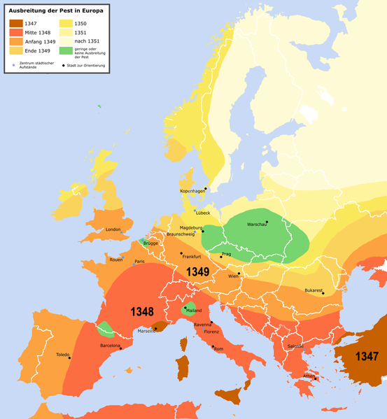
English: Spreading of the en:Black Death in Europe between 1347 and 1351, apparently copied from a work called "Atlas zur Weltgeschichte" (perhaps dtv-Atlas? If so, Kinder and Hilgemann (eds.), dtv-Atlas zur Weltgeschichte was published in 35(!) editions between 1964 and 2002, and it would be crucial to know which edition we are basing this on).
The details of the map are to be taken with a large grain of salt. It is roughly compatible with this Britannica map (copy, dated 1994), but the details vary significantly. Other significant differences exist with this map (an unreferenced scan of a professional publication), where e.g. the area of Poland/Silesia marked "unaffected" in this map is part of a much larger area marked as "Area for which there is insufficient information". Here is another map with a somewhat more conservative epistemology, referenced to "insecta-inspecta.com", where it was posted in 2000 (and therefore uninfluenced by the 2005 upload of this map). An academically published map for comparison: [1] cited to: D. Sherman and J. Salisbury, The West in the World: Volume I to 1715. McGraw-Hill, Boston, 3rd edition (2008), not necessarily better than the Britannica map, as it is a rough sketched used for the purposes of some argument about network theory, and not a medievalist publication dedicated to the history of the Black Death as such.Deutsch: Ausbreitung der de:Pest in Europa zwischen 1347 und 1351 |
| Час створення | |
| Джерело | "Atlas zur Weltgeschichte"(?) |
| Автор | Roger_Zenner |
| Ліцензія (Повторне використання цього файлу) |
Creative Commons by/sa/de |
| Інші версії |
[] Better than many files each for one language is to create one multilanguaged file (SVG switch option).
|


- Version 1.1
- Changelog: 1.0: new map -> 1.1: more details, color changes, more cities
- Ви можете вільно:
- ділитися – копіювати, поширювати і передавати твір
- модифікувати – переробляти твір
- При дотриманні таких умов:
- зазначення авторства – Ви повинні вказати авторство, надати посилання на ліцензію і вказати, чи якісь зміни було внесено до оригінального твору. Ви можете зробити це в будь-який розсудливий спосіб, але так, щоб він жодним чином не натякав на те, наче ліцензіар підтримує Вас чи Ваш спосіб використання твору.
- поширення на тих же умовах – Якщо ви змінюєте, перетворюєте або створюєте іншу похідну роботу на основі цього твору, ви можете поширювати отриманий у результаті твір тільки на умовах такої ж або сумісної ліцензії.

Історія файлу
Клацніть на дату/час, щоб переглянути, як тоді виглядав файл.
| Дата/час | Мініатюра | Розмір об'єкта | Користувач | Коментар | |
|---|---|---|---|---|---|
| поточний | 22:42, 3 квітня 2016 | | 1280 × 1387 (350 КБ) | Poeticbent | made the map readable again |
| 01:32, 24 травня 2015 |  | 1280 × 1387 (330 КБ) | Alphathon | Removed border in Northern Serbia (seems roughly correspond to the Autonomous Province of Vojvodina; shouldn't be on there regardless). Added border between Montenegro and Serbia (which separated in 2006). Also added Kosovo border. | |
| 13:18, 21 січня 2010 |  | 1280 × 1387 (304 КБ) | Chesnok | deleted artificial Rybinsk reservoir and reservoirs on Dnieper | |
| 03:46, 3 квітня 2005 |  | 1280 × 1387 (378 КБ) | Roger Zenner | ||
| 03:30, 3 квітня 2005 |  | 1280 × 1354 (394 КБ) | Roger Zenner | ||
| 02:17, 3 квітня 2005 |  | 1280 × 1346 (373 КБ) | Roger Zenner | *'''english''': spreading of the en:pest in Europe between 1347 and 1351 *'''deutsch''': Ausbreitung der de:Pest in Europa zwischen 1347 und 1351 *License: Creative Commons by/sa/de *Author: Roger_Zenner *Date: 2005/03/04 |
Використання файлу
Нема сторінок, що використовують цей файл.
Глобальне використання файлу
Цей файл використовують такі інші вікі:
- Використання в als.wikipedia.org
- Використання в an.wikipedia.org
- Використання в arz.wikipedia.org
- Використання в azb.wikipedia.org
- Використання в bg.wikipedia.org
- Використання в cy.wikipedia.org
- Використання в de.wikipedia.org
- Використання в de.wikibooks.org
- Використання в frr.wikipedia.org
- Використання в fr.wikipedia.org
- Використання в gl.wikipedia.org
- Використання в hu.wikipedia.org
- Використання в hy.wikipedia.org
- Використання в ia.wikipedia.org
- Використання в incubator.wikimedia.org
- Використання в io.wikipedia.org
- Використання в lad.wikipedia.org
- Використання в la.wikipedia.org
- Використання в nl.wikipedia.org
- Використання в sl.wikipedia.org
- Використання в www.wikidata.org
- Використання в zh-min-nan.wikipedia.org