Файл:Rzeczpospolita voivodships.png
Повна роздільність (2000 × 1568 пікселів, розмір файлу: 448 КБ, MIME-тип: image/png)
| Відомості про цей файл містяться на Вікісховищі — централізованому сховищі вільних файлів мультимедіа для використання у проектах Фонду Вікімедіа. |
Опис файлу
| Опис |
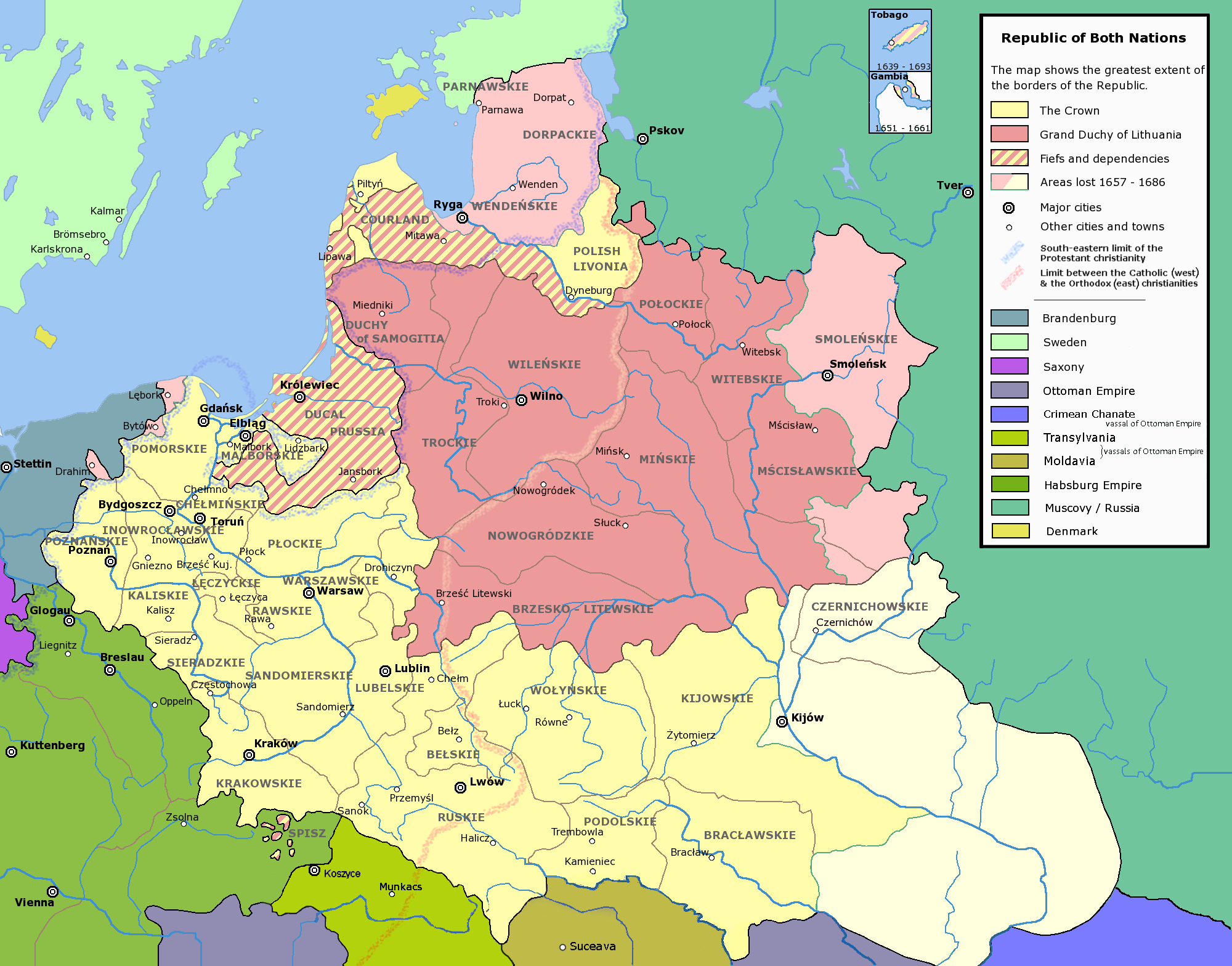
Deutsch: die polnisch-litauische de:Rzeczpospolita (Adelsrepublik)
Polski: Mapa przedstawiająca Rzeczpospolitą Obojga Narodów (czyli Koronę i Wielkie Księstwo Litewskie). Nazwy jednostek administracyjnych (województw, etc.) są przedstawione w języku polskim.
English: w:Voivodships of the Republic of Both Nations. The names of the voivodships are in Polish. In Polish the voivodships and other units of administrative division are traditionally referred to with their adjective forms, i.e. Płock Voivodship is referred to as (Województwo) Płockie (Literally Plockian voivodship), Podole Voivodship as (Województwo) Podolskie (literally Podolian Voivodship) and so on.
Français : Voïdodies de la République des Deux Nations. Noms géographiques en polonais. Les noms polonais des unités administratives sont sous leur forme adjective. Par exemple, la voïvodie de Plock est nommée Województwo Płockie (litéralement la "Voïvodie Plockienne").
|
| Джерело | Власна робота |
| Автор | Halibutt |
| Ліцензія (Повторне використання цього файлу) |
GFDL and Creative Commons Attribution-ShareAlike 3.0 |
| Інші версії | العربيَّة |
The following is a list of maps created by Halibutt and uploaded to commons, as well as their present and projected derivatives.
| Parent Image | Image | Description | |||||||||||
|---|---|---|---|---|---|---|---|---|---|---|---|---|---|
| Maps by Halibutt | |||||||||||||
| Image:Rzeczpospolita.png | Image:Rzeczpospolita.png | The Republic in 17th and 18th century | |||||||||||
| Image:Rzeczpospolita 1600.png | The Republic after the Treaty of Dywilino | ||||||||||||
| Image:Rzeczpospolita voivodships.png | Voivodships of The Republic | ||||||||||||
| Image:Rzeczpospolita_Potop.png | The Republic during The Deluge and Chmielnicki Uprising, with major battles of the era marked | ||||||||||||
| Magnates and their lands and domains | |||||||||||||
| 1st • 2nd • 3rd | Partitions of Poland | ||||||||||||
| War of the constitution | |||||||||||||
| Image:Rzeczpospolita.xcf | SOURCE FILE - GIMP format | ||||||||||||
| Image:Poland 1939.png | Image:Poland 1939.png | Poland in 1939 | |||||||||||
| Image:Dywizje wrzesien 1.png | Order of Battle on September 1st, during the Polish Defence War of 1939 | ||||||||||||
| Image:Poland 1939.xcf | SOURCE FILE - GIMP format | ||||||||||||
| Image:Polska kontur bialy.png | Image:Polska kontur bialy.png | Contour map of Poland AD 1999, for use with various locator maps | |||||||||||
| Image:Rzeczpospolita 1923.png | Image:Rzeczpospolita 1923.png | Map of Poland 1918-1939, currently under development | |||||||||||
| Image:PBW March 1919.png | Polish-Bolshevik War - fronts in March of 1919 | ||||||||||||
| Image:PBW December 1919.png | Polish-Bolshevik War - fronts in December of 1919 | ||||||||||||
| Image:PBW June 1920.png | Polish-Bolshevik War - fronts in July of 1920 | ||||||||||||
| Image:PBW August 1920.png | Polish-Bolshevik War - fronts in August of 1920 | ||||||||||||
| Polish Defence War of 1939 | |||||||||||||
| Polish areas annexed by Germany, Lithuania, Slovakia and the Soviet Union | |||||||||||||
| German concentration camps in Poland | |||||||||||||
| Curzon line | |||||||||||||
| Major battles of the Polish-Bolshevik War | |||||||||||||
| names • no names | Polish/Czechoslovak/Lithuanian/German/Ukrainian claims in 1920's | ||||||||||||
| Image:Rzeczpospolita Central Lithuania.png | Central Lithuania | ||||||||||||
| Image:Rzeczpospolita Lithuania claims.png | Central Lithuania as compared with other Lithuanian claims | ||||||||||||
| Image:Rzeczpospolita 1789-1920.png | Post-1922 borders compared with the territory of Poland before the partitions | ||||||||||||
| Warsaw Uprising and the Operation Tempest | |||||||||||||
| Poland partitioned between the Soviets and the Germans | |||||||||||||
| Image:Rzeczpospolita 1939 Polish divisions.png | Polish divisions on September 1, 1939 | ||||||||||||
| Home Army inspectorates | |||||||||||||
| Image:Rzeczpospolita 1922.xcf | SOURCE FILE - GIMP format | ||||||||||||
| Image:Rzeczpospolita 1937.svg | Vector version!!!! | layered version available on request | |||||||||||
Ліцензування
Since the legal status of the above comment has been questioned, I hereby grant anyone the right to treat it as either a standard copyright notice, invariant section, legal statement, legal advice, friendly suggestion or a mere comment, depending on his or hers own choice. |
|

|
Ця ілюстрація обрана зображенням дня для 5 квітня 2006 року. Опис зображення: Інші мови:
Čeština: Vojvodství Republiky obou národů (polsko-litevské unie). Français : Voïvodies (régions administrative) de l'union polono-lituanienne. Polski: Podział administracyjny Rzeczypospolitej Obojga Narodów Português: Voivodias da comunidade comum polaco-lituana. Русский: Воеводства Речи Посполитой ไทย: เขตการปกครองของเครือรัฐโปแลนด์-ลิทัวเนีย |
Історія файлу
Клацніть на дату/час, щоб переглянути, як тоді виглядав файл.
| Дата/час | Мініатюра | Розмір об'єкта | Користувач | Коментар | |
|---|---|---|---|---|---|
| поточний | 18:41, 13 квітня 2020 | | 2000 × 1568 (448 КБ) | Claude Zygiel | Details since Stier, H.-E. (ed.) ''Grosser Atlas zur Weltgeschichte'', Westermann 1985, {{ISBN|3-14-100919-8}}, ''Putzger historischer Weltatlas'', Cornelsen 1990, {{ISBN|3-464-00176-8}} & Denis J.P., Frachon A., Giraud J., Michel R., Valet O. (eds.) ''Atlas des Religions'' - H.S. ''Le Monde'' 2009. |
| 13:39, 24 лютого 2010 |  | 2000 × 1568 (273 КБ) | Dcoetzee | Remove watermark, pngcrush | |
| 07:57, 7 лютого 2007 |  | 2000 × 1568 (253 КБ) | Tene~commonswiki | Optimised (0) | |
| 19:23, 13 грудня 2004 |  | 2000 × 1568 (397 КБ) | Halibutt | Ok, final version at last (unless you have some more comments or suggestions) | |
| 07:47, 10 грудня 2004 |  | 2000 × 1568 (386 КБ) | Halibutt | Voivodships of the Republic of Both Nations<br><br> A derivative work of Image:Rzeczpospolita.png<br>Please refer to that graphic's page for more detailed description, licensing information and such.<br>{{User:Halibutt/GFDL}}<br>{{User:Halibutt/maps} |
Використання файлу
Нема сторінок, що використовують цей файл.
Глобальне використання файлу
Цей файл використовують такі інші вікі:
- Використання в af.wikipedia.org
- Використання в ar.wikipedia.org
- Використання в azb.wikipedia.org
- Використання в bg.wikipedia.org
- Використання в da.wikipedia.org
- Використання в de.wikipedia.org
- Використання в el.wikipedia.org
- Використання в en.wikipedia.org
- Talk:Daniel Gabriel Fahrenheit/Archive 1
- Lublin Voivodeship
- Grand Duchy of Lithuania
- Crown of the Kingdom of Poland
- Portal:Lithuania
- Administrative divisions of Poland
- Portal:Maps/Maps/Political
- Portal:Maps/Maps/Political/10
- Talk:Voivodeships of Poland/Archive 1
- Talk:Name of Ukraine/Archive 1
- Talk:Polish–Lithuanian Commonwealth/Archive 2
- User:Falcaorib
- Використання в eo.wikipedia.org
- Використання в es.wikipedia.org
- Використання в fr.wikipedia.org
- Використання в he.wikipedia.org
- Використання в ia.wikipedia.org
- Використання в it.wikipedia.org
- Використання в ka.wikipedia.org
- Використання в ko.wikipedia.org
- Використання в ku.wikipedia.org
- Використання в lt.wikipedia.org
Переглянути сторінку глобального використання цього файлу.