Файл:USGS magnitude 8 earthquakes since 1900.svg
Перейти до навігації
Перейти до пошуку

Розмір цього попереднього перегляду PNG для вихідного SVG-файлу: 512 × 512 пікселів. Інші роздільності: 240 × 240 пікселів | 480 × 480 пікселів | 768 × 768 пікселів | 1024 × 1024 пікселів | 2048 × 2048 пікселів.
Повна роздільність (SVG-файл, номінально 512 × 512 пікселів, розмір файлу: 112 КБ)
| Відомості про цей файл містяться на Вікісховищі — централізованому сховищі вільних файлів мультимедіа для використання у проектах Фонду Вікімедіа. |
Опис файлу
| Опис |
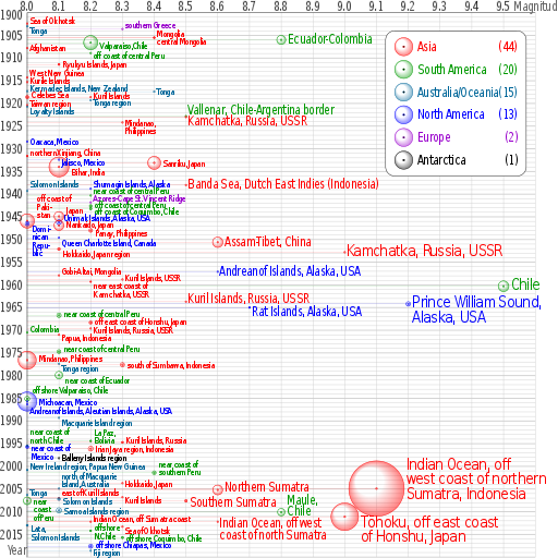
English: Earthquakes of moment magnitude 8.0 and greater from 1900 to 2018. The apparent 3D volumes of the bubbles are linearly proportional to their respective fatalities, i.e. their radii are linearly proportional to the cube root of the fatalities. Data is from https://earthquake.usgs.gov/earthquakes/eqarchives/year/mag8/magnitude8_1900_date.php ; The colour indicates the continent, and the legend counts the number of quakes for each. Notice the absence of Africa and the low presence of Antarctica and Europe. |
| Джерело | Власна робота |
| Автор | Cmglee |
| SVG розвиток | Вихідний код цього SVG-файлу правильний. Це векторне зображення було створено з допомогою perl This file uses embedded text that can be easily translated using a text editor. |
| Сирцевий код | PERL codetest
Perl script to create above; please do not remove.
#!/usr/bin/perl
$data_string = qq`
as|1902/06/11 05:|50.00|148.00|8.0||Sea of Okhotsk|-8
oc|1903/01/04 05:07|-20.00|-175.00|8.0||Tonga|8
eu|1903/08/11 04:32|36.36|22.97|8.3||southern Greece|-10
as|1905/07/09 09:40|49.0|99.0|8.4||Mongolia|-10
as|1905/07/23 02:46|49.0|98.0|8.4||central Mongolia|8
sa|1906/01/31 15:36|1.0|-81.5|8.8|1000|Colombia-Ecuador||Ecuador-Colombia
sa|1906/08/17 00:40|-33.0|-72.0|8.2|3882|Valparaiso, Chile|5|Valparaiso,Chile
as|1907/10/21 04:23|38.00|69.00|8.0||Afghanistan
sa|1908/12/12 12:08|-14.0|-78.0|8.2||off the coast of central Peru|5|off coast of central Peru
as|1911/06/15 14:26|28.0|130.0|8.1|12|Ryukyu Islands, Japan
as|1914/05/26 14:22|-2.|137.|8.0||West New Guinea|-10
as|1915/05/01 05:00|47.|155.|8.0||Kurile Islands|-4
oc|1917/05/01 18:26|-29.0|-177.0|8.0||Kermadec Islands, New Zealand|-8
oc|1917/06/26 05:49|-15.0|-173.0|8.4||Tonga
as|1918/08/15 12:18|5.653|123.563|8.0|50|Celebes Sea|-5
as|1918/09/07 17:16|45.5|151.5|8.2||Kuril Islands|-4
oc|1919/04/30 07:17|-19.823|-172.215|8.2||Tonga region|5
as|1920/06/05 04:21|23.5|122.0|8.0||Taiwan region|-5
oc|1920/09/20 14:39|-20.0|168.0|8.0||Loyalty Islands|10
sa|1922/11/11 04:32|-28.553|-70.755|8.5||Chile-Argentina Border|-12|Vallenar, Chile-Argentina border
as|1923/02/03 16:01|54.0|161.0|8.5||Kamchatka|10|Kamchatka, Russia, USSR
as|1924/04/14 16:20|7.023|125.954|8.3||Mindanao, Philippines||Mindanao,~Philippines
na|1928/06/17 03:19|16.33|-96.7|8.0||Oaxaca, Mexico
as|1931/08/10 21:18|47.1|89.8|8.0|5|northern Xinjiang, China|-8
na|1932/06/03 10:36|19.84|-103.99|8.1||Jalisco, Mexico|5
as|1933/03/02 17:31|39.22|144.62|8.4|2990|Sanriku, Japan
as|1934/01/15 08:43|27.55|87.09|8.1|10700|Bihar, India|10
as|1938/02/01 19:04|-5.05|131.62|8.5||Banda Sea||Banda Sea, Dutch East Indies (Indonesia)
na|1938/11/10 20:18|55.33|-158.37|8.2||Shumagin Islands, Alaska|-12
oc|1939/04/30 02:55|-10.5|158.5|8.0||Solomon Islands|-15
sa|1940/05/24 16:33|-10.5|-77.0|8.2||near the Coast of central Peru|-12|near coast of central Peru
eu|1941/11/25 18:03|37.171|-18.960|8.2||Azores-Cape St. Vincent Ridge|-10
sa|1942/08/24 22:50|-15.0|-76.0|8.2|30|Off the coast of central Peru|-3|off coast of central Peru
sa|1943/04/06 16:07|-30.75|-72.0|8.2|18|off the coast of Coquimbo, Chile|5|off coast of Coquimbo, Chile
as|1944/12/07 04:35|33.75|136.00|8.1|1223|Tonankai, Japan|-15|Japan
as|1945/11/27 21:57|24.5|63.0|8.0|4000|off the coast of Pakistan|-50|off coast of~Paki-~stan
na|1946/04/01 12:28|52.75|-163.50|8.1|165|Unimak Islands, Alaska|-10|Unimak Islands, Alaska, USA
na|1946/08/04 17:51|19.25|-69.00|8.0|100|Dominican Republic|10|Domi-~nican~Repu-~blic
as|1946/12/20 19:19|32.5|134.5|8.1|1330|Nankaido, Japan|-2
as|1948/01/24 17:46|10.5|122.0|8.2|72|Panay, Philippines|5
na|1949/08/22 04:01|53.62|-133.27|8.1||Queen Charlotte Island, B.C., Canada|10|Queen Charlotte Island, Canada
as|1950/08/15 14:09|28.5|96.5|8.6|1526|Assam-Tibet||Assam-Tibet, China
as|1952/03/04 01:22|42.5|143.0|8.1|31|Hokkaido, Japan region|10
as|1952/11/04 16:58|52.76|160.06|9.0||Kamchatka, Russia||Kamchatka, Russia, USSR
na|1957/03/09 14:22|51.56|-175.39|8.6||Andreanof Islands, Alaska||Andreanof Islands, Alaska, USA
as|1957/12/04 03:37|45.15|99.21|8.1||Gobi-Altai, Mongolia|-10
as|1958/11/06 22:58|44.329|148.623|8.3||Kuril Islands|-3|Kuril Islands, USSR
as|1959/05/04 07:15|53.351|159.645|8.2|1|near the east coast of Kamchatka|8|near east coast of~Kamchatka, USSR
sa|1960/05/22 19:11|-38.29|-73.05|9.5|1655|Chile
as|1963/10/13 05:17|44.9|149.6|8.5||Kuril Islands|-5|Kuril Islands, Russia, USSR
na|1964/03/28 03:36|61.02|-147.65|9.2|125|Prince William Sound, Alaska||Prince William Sound,~Alaska, USA
na|1965/02/04 05:01|51.21|-178.50|8.7|5|Rat Islands, Alaska|10|Rat Islands, Alaska, USA
sa|1966/10/17 21:41|-10.807|-78.684|8.1|125|near the coast of central Peru|-5|near coast of central Peru
as|1968/05/16 00:49|40.903|143.346|8.2|47|off the east coast of Honshu, Japan|-4|off east coast of Honshu, Japan
as|1969/08/11 21:27|43.478|147.815|8.2||Kuril Islands|2|Kuril Islands, Russia, USSR
sa|1970/07/31 17:08|-1.49|-72.56|8.0||Colombia|-8
as|1971/01/10 07:17|-3.132|139.697|8.1||Papua, Indonesia|5
sa|1974/10/03 14:21|-12.254|-77.524|8.1|78|near the coast of central Peru|-7|near coast of central Peru
as|1976/08/16 16:11|6.292|124.090|8.0|8000|Mindanao, Philippines|-5
oc|1977/06/22 12:08|-22.878|-175.900|8.1||Tonga region|8
as|1977/08/19 06:08|-11.085|118.464|8.3|100|south of Sumbawa, Indonesia
sa|1979/12/12 07:59|1.598|-79.358|8.1|600|near the coast of Ecuador|10|near coast of Ecuador
sa|1985/03/03 22:47|-33.135|-71.871|8.0|177|offshore Valparaiso, Chile|-20
na|1985/09/19 13:17|18.190|-102.533|8.0|9500|Michoacan, Mexico
na|1986/05/07 22:47|51.520|-174.776|8.0||Andreanof Islands, Aleutian Islands, Alaska|15|Andreanof Islands, Aleutian Islands, Alaska, USA
oc|1989/05/23 10:54|-52.341|160.568|8.1||Macquarie Island region|10
sa|1994/06/09 00:33|-13.841|-67.553|8.2|5|La Paz, Bolivia|-20|La Paz,~Bolivia
as|1994/10/04 13:22|43.773|147.321|8.3|11|Kuril Islands|-5|Kuril Islands, Russia
sa|1995/07/30 05:11|-23.340|-70.294|8.0|3|Near Coast of Northern Chile|-32|near coast of~north Chile
na|1995/10/09 15:35|19.055|-104.205|8.0|49|Near Coast of Jalisco, Mexico|2|near coast of~Mexico
as|1996/02/17 05:59|-0.891|136.952|8.2|166|Irian Jaya region, Indonesia
an|1998/03/25 03:12|-62.877|149.527|8.1||Balleny Islands region|-2
oc|2000/11/16 04:54|-3.980|152.169|8.0|2|New Ireland region, Papua New Guinea|-8
sa|2001/06/23 20:33|-16.264|-73.641|8.4|75|near the coast of southern Peru|-20|near coast of~southern Peru
as|2003/09/25 19:50|41.815|143.910|8.3||Hokkaido, Japan region||Hokkaido, Japan
oc|2004/12/23 14:59|-49.312|161.345|8.1||north of Macquarie Island|-28|north of Macquarie~Island, Australia
as|2004/12/26 00:58|3.295|95.982|9.1|227898|off the west coast of northern Sumatra|-50|Indian Ocean, off~west coast of northern~Sumatra, Indonesia
as|2005/03/28 16:09|2.074|97.013|8.6|1313|Northern Sumatra, Indonesia|-5|Northern Sumatra
oc|2006/05/03 15:26|-20.187|-174.123|8.0||Tonga|-5
as|2006/11/15 11:14|46.592|153.226|8.3||Kuril Islands|5
as|2007/01/13 04:23:21|46.243|154.524|8.1||East of the Kuril Islands|-13|east of Kuril Islands
oc|2007/04/01 20:39:58|-8.466|157.043|8.1|34|Solomon Islands|5
sa|2007/08/15 23:40:57|-13.386|-76.603|8.0|650|Near the Coast of Central Peru||near~coast~of Peru
as|2007/09/12 11:10:26|-4.438|101.367|8.5|25|Southern Sumatra, Indonesia|5|Southern Sumatra
oc|2009/09/29 17:48:10|-15.489|-172.095|8.1|192|Samoa Islands region|0
sa|2010/02/27 06:34:14|-35.846|-72.719|8.8|577|Offshore Maule, Chile|-25|Maule,~Chile
as|2011/03/11 05:46:23|38.322|142.369|9.0|28050|Near the East Coast of Honshu, Japan|15|Tōhoku, off east coast~of Honshu, Japan
as|2012/04/11 08:38:37|2.311|93.063|8.6||off the west coast of northern Sumatra|5|Indian Ocean, off west~coast of north Sumatra
as|2012/04/11 10:43:09|0.773|92.452|8.2||off the west coast of northern Sumatra|-7|Indian Ocean, off Sumatra coast
oc|2013/02/06 01:12:27|-10.738|165.138|8.0|13|Lata,~Solomon Islands|7|
as|2013/05/24 06:44:49|54.874|153.281|8.3||Sea of Okhotsk|7|
sa|2014/04/01 23:46:47|-19.642|-70.817|8.2|6|offshore~N.Chile|-7|
sa|2015/09/16 22:54|-31.570|-71.654|8.3|14|offshore Coquimbo, Chile
na|2017/09/08 04:49|15.022|-93.899|8.2|98|offshore Chiapas, Mexico|-3
oc|2018/08/19 00:19|-18.178|-178.111|8.2|0|Fiji region|4
`;
%continents = (
"na" => { "colour" => "#0000ff", "count" => 0, "name" => "North America" },
"sa" => { "colour" => "#009900", "count" => 0, "name" => "South America" },
"eu" => { "colour" => "#9900cc", "count" => 0, "name" => "Europe" },
"af" => { "colour" => "#996600", "count" => 0, "name" => "Africa" },
"as" => { "colour" => "#ff0000", "count" => 0, "name" => "Asia" },
"oc" => { "colour" => "#006699", "count" => 0, "name" => "Australia/Oceania" },
"an" => { "colour" => "#000000", "count" => 0, "name" => "Antarctica" },
undef);
@continent_order = ("as", "sa", "oc", "na", "eu", "an", "af");
# @continent_order = ("na","sa", "eu", "af", "as", "oc", "an");
$mag_min = 8; $mag_max = 9.6; $date_min = 1900; $date_max = 2020;
$x_min = 0; $x_max = &x($mag_max); $y_min = 0; $y_max = &y($date_max);
$x_legend = 790; $y_legend = 40; $w_legend = 310; $h_legend = 320;
$x_viewbox = -60; $y_viewbox = -28; $width_viewbox = 1230; $height_viewbox = 1230;
$out_graph = $out_legend = $out_grid = $out_grad = "";
$x_margin = &x($mag_min);
sub year_fraction {
($y, $m, $d) = split(/\//, $_[0]);
# $y = $_[0];
# $m = $_[1] || 1;
# $d = $_[2] || 1;
$is_leap_year = $y % 100 ? ($y % 4 == 0) : ($y % 400 == 0);
$day_of_year = int($d - ($m < 3 ? 30 : $is_leap_year ? 31 : 32) + 30.56 * $m);
return $y + ($day_of_year - 1) / ($is_leap_year ? 366 : 365);
}
sub x { return sprintf("%.3f", 700 * ($_[0] - $mag_min)); }
sub y { return sprintf("%d", 10 * ($_[0] - $date_min)); }
$double_dash = "-" . "-";
$file_out = $0; $file_out =~ s/[^\.]*$/svg/;
@data = split(/\n/, $data_string);
foreach (@data) {
if ($_ && substr($_, 0, 1) ne "#") {
($continent, $datetime, $latitude, $longitude, $magnitude, $fatalities, $region, $label_offset, $label) = split(/\|/, $_);
if ($magnitude >= $mag_min) {
print "$continent\t$datetime\t$latitude\t$longitude\t$magnitude\t$fatalities\t$region\t$label_offset\t$label\n";
($date, $time) = split(/\s/, $datetime);
$x = &x($magnitude);
$y = &y(&year_fraction($date));
$r = $fatalities ** (1 / 3);
$x_label = $x + $r + 4;
$y_label = $y + $label_offset + 8;
$colour = $continents{$continent}{"colour"};
++$continents{$continent}{"count"};
if ($label eq "") { $label = $region; }
if ($label =~ m/~/) {
$label =~ s`~`</tspan><tspan x="0" dy="0.9em">`g;
$label = qq`<tspan>${label}</tspan>`;
}
$font_size = $magnitude < 8.5 ? qq` font-size="20"` :
($magnitude >= 9 ? qq` font-size="36"` : qq``);
$out_graph .= qq`
<g stroke="${colour}" fill="${colour}">
<text transform="translate(${x_label},${y_label}) scale(0.8,1)" x="0" y="0"${font_size} stroke="none">${label}</text>
<circle cx="${x}" cy="${y}" r="${r}" fill="url(#grad_${continent})"/>
<circle cx="${x}" cy="${y}" r="2" fill-opacity="0.5"/>
<path d="M ${x} ${y} H ${x_margin}" stroke-width="0.5" stroke-opacity="0.5"/>
</g>`;
}
}
}
$y = 35;
foreach (@continent_order) {
$count = $continents{$_}{"count"};
if ($count > 0) {
$colour = $continents{$_}{"colour"};
$name = $continents{$_}{"name"};
$out_grad .= qq`
<radialGradient id="grad_${_}" cx="50%" cy="50%" r="50%" fx="25%" fy="25%">
<stop offset="50%" stop-color="${colour}" stop-opacity="0"/>
<stop offset="100%" stop-color="${colour}" stop-opacity="0.5"/>
</radialGradient>`;
$out_legend .= qq`
<text transform="translate(70,${y}) scale(0.8,1)" x="0" y="10" fill="${colour}"><tspan>${name}</tspan><tspan x="280" text-anchor="end">(${count})</tspan></text>
<circle cx="40" cy="${y}" r="20" stroke="${colour}" fill="url(#grad_${_})"/>
<circle cx="40" cy="${y}" r="2" stroke="${colour}"/>`;
$y += 50;
}
}
for ($mag = $mag_max; $mag >= $mag_min; $mag -= 0.1) {
$x = &x($mag);
$mag = sprintf("%0.1f", $mag);
$out_grid .= qq`
<use xlink:href="#grid_x" transform="translate(${x},0)"/>`;
if ($mag < $mag_max) {
$out_grid .= qq`
<text transform="translate(${x},-5) scale(0.8,1)" x="0" y="0" text-anchor="middle">${mag}</text>`;
}
}
for ($date = $date_max; $date >= $date_min; $date -= 5) {
$y = &y($date);
if ($date > $date_min) {
$out_grid .= qq`
<use xlink:href="#grid_y_5" transform="translate(0,${y})"/>`;
if ($date < $date_max) {
$out_grid .= qq`
<text transform="translate(-5,${y}) scale(0.8,1)" x="0" y="10" text-anchor="end">${date}</text>`;
}
} else {
$out_grid .= qq`
<text transform="translate(-5,${y}) scale(0.8,1)" x="0" y="15" text-anchor="end">${date}</text>`;
}
}
open (FILE_OUT, ">$file_out");
print FILE_OUT qq`<?xml version="1.0" encoding="utf-8"?>
<svg xmlns="http://www.w3.org/2000/svg" xmlns:xlink="http://www.w3.org/1999/xlink" width="100%" height="100%" viewBox="${x_viewbox} ${y_viewbox} ${width_viewbox} ${height_viewbox}">
<title>Magnitude 8.0 and greater earthquakes since 1900</title>
<desc>Earthquakes of moment magnitude 8.0 and greater since 1900, charted by CMG Lee. The apparent 3D volumes of the bubbles are linearly proportional to their respective fatalities, i.e. their radii are linearly proportional to the cube root of the fatalities. Data is from https://earthquake.usgs.gov/earthquakes/eqarchives/year/mag8/magnitude8_1900_date.php , http://comcat.cr.usgs.gov/earthquakes/eventpage/usc000f1s0 and http://comcat.cr.usgs.gov/earthquakes/eventpage/usb000h4jh .</desc>
<defs>${out_grad}
<path id="grid_x" d="M 0 ${y_min} V ${y_max}"/>
<path id="grid_y" d="M ${x_min} 0 h -1 H ${x_max}"/>
<path id="grid_y_tick" d="M ${x_min} 0 h -2 H ${x_max}" stroke-width="2"/>
<g id="grid_y_5">
<use xlink:href="#grid_y_tick"/>
<use xlink:href="#grid_y" transform="translate(0,-10)"/>
<use xlink:href="#grid_y" transform="translate(0,-20)"/>
<use xlink:href="#grid_y" transform="translate(0,-30)"/>
<use xlink:href="#grid_y" transform="translate(0,-40)"/>
</g>
</defs>
<rect x="${x_viewbox}" y="${y_viewbox}" width="${width_viewbox}" height="${height_viewbox}" fill="#ffffff"/>
<g font-family="sans-serif" letter-spacing="-2" font-size="28" text-anchor="start">
<g stroke="#cccccc" fill="#000000">${out_grid}
<path d="M 0 ${y_max} V 0 H ${x_max}" stroke="#000000" fill="none"/>
</g>
<g transform="scale(0.8,1)" fill="#666666">
<text x="-55" y="1195">Year</text>
<text x="1340" y="-5">Magnitude</text>
</g>
<g transform="translate(${x_legend},${y_legend})">
<rect x="0" y="0" width="${w_legend}" height="${h_legend}" rx="20" ry="20" stroke="#000000" fill="#ffffff"/>${out_legend}
</g>
${out_graph}
</g>
</svg>
<!${double_dash} Perl script to create above; please do not remove.
`;
open (FILE_IN, $0);
while (<FILE_IN>) { print FILE_OUT $_; }
close FILE_IN;
print FILE_OUT "# ${double_dash}>";
close FILE_OUT;
#
|
Це векторне зображення було створено з допомогою perl
Ліцензування
Я, власник авторських прав на цей твір, добровільно публікую його на умовах таких ліцензій:
Цей файл ліцензований на умовах Creative Commons Attribution-Share Alike 3.0 Unported
- Ви можете вільно:
- ділитися – копіювати, поширювати і передавати твір
- модифікувати – переробляти твір
- При дотриманні таких умов:
- зазначення авторства – Ви повинні вказати авторство, надати посилання на ліцензію і вказати, чи якісь зміни було внесено до оригінального твору. Ви можете зробити це в будь-який розсудливий спосіб, але так, щоб він жодним чином не натякав на те, наче ліцензіар підтримує Вас чи Ваш спосіб використання твору.
- поширення на тих же умовах – Якщо ви змінюєте, перетворюєте або створюєте іншу похідну роботу на основі цього твору, ви можете поширювати отриманий у результаті твір тільки на умовах такої ж або сумісної ліцензії.

|
Дозволяється копіювати, розповсюджувати та/або модифікувати цей документ на умовах ліцензії GNU FDL версії 1.2 або більш пізньої, виданої Фондом вільного програмного забезпечення, без незмінних розділів, без текстів, які розміщені на першій та останній обкладинці. Копія ліцензії знаходиться у розділі GNU Free Documentation License. |
Ви можете обрати ліцензію на ваш розсуд.
Історія файлу
Клацніть на дату/час, щоб переглянути, як тоді виглядав файл.
| Дата/час | Мініатюра | Розмір об'єкта | Користувач | Коментар | |
|---|---|---|---|---|---|
| поточний | 07:53, 7 жовтня 2018 | | 512 × 512 (112 КБ) | JoKalliauer | Inkscape: --verb=SelectionUnGroup (inkscape --verb=EditSelectAll --verb=SelectionUnGroup --verb=SelectionUnGroup --verb=SelectionUnGroup --verb=SelectionUnGroup --verb=SelectionUnGroup --verb=FileSave --verb=FileClose ./${file}u.svg --verb=FileQuit) |
| 22:04, 6 жовтня 2018 |  | 512 × 512 (40 КБ) | JoKalliauer | try to simplify file | |
| 18:47, 5 жовтня 2018 |  | 512 × 512 (61 КБ) | Cmglee | Try to fix bubbles. | |
| 18:18, 4 жовтня 2018 |  | 512 × 512 (61 КБ) | Cmglee | Update up to 2018-10-04. | |
| 23:21, 2 квітня 2015 |  | 512 × 512 (60 КБ) | Cmglee | Add 2014 quake, axis labels (w:user_talk:cmglee#Earthquake_graph) and minor cosmetic changes. | |
| 12:13, 3 липня 2013 |  | 512 × 512 (60 КБ) | Cmglee | Add 2013 quakes and minor cosmetic changes. | |
| 22:48, 13 квітня 2012 |  | 512 × 512 (59 КБ) | Cmglee | Add counts to legend and refine more labels. | |
| 22:09, 13 квітня 2012 |  | 512 × 512 (59 КБ) | Cmglee | Refine labels. | |
| 21:16, 13 квітня 2012 |  | 512 × 512 (58 КБ) | Cmglee | Add magnitude 8.0 to 8.4 earthquakes to match filename. | |
| 19:24, 13 квітня 2012 |  | 512 × 512 (23 КБ) | Cmglee | Shorten label to fit. |
Використання файлу
Така сторінка використовує цей файл:
Глобальне використання файлу
Цей файл використовують такі інші вікі:
- Використання в am.wikipedia.org
- Використання в ar.wikipedia.org
- Використання в en.wikipedia.org
- Використання в fa.wikipedia.org
- Використання в gl.wikipedia.org
- Використання в hu.wikipedia.org
- Використання в id.wikipedia.org
- Використання в ko.wikipedia.org
- Використання в mnw.wikipedia.org
- Використання в ms.wikipedia.org
- Використання в pa.wikipedia.org
- Використання в pt.wikipedia.org
- Використання в tr.wikipedia.org
- Використання в zh.wikipedia.org