Файл:World in 2000 BC.svg
Перейти до навігації
Перейти до пошуку

Розмір цього попереднього перегляду PNG для вихідного SVG-файлу: 800 × 397 пікселів. Інші роздільності: 320 × 159 пікселів | 640 × 318 пікселів | 1024 × 508 пікселів | 1280 × 635 пікселів | 2560 × 1271 пікселів | 4500 × 2234 пікселів.
Повна роздільність (SVG-файл, номінально 4500 × 2234 пікселів, розмір файлу: 847 КБ)
| Відомості про цей файл містяться на Вікісховищі — централізованому сховищі вільних файлів мультимедіа для використання у проектах Фонду Вікімедіа. |
Edit it
Опис файлу
| Опис |
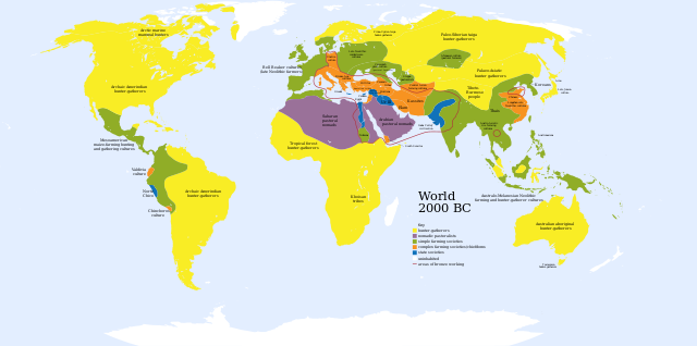
English: A map of the world, circa 2000 BC
Ελληνικά: Πολιτισμοί το 2000 π.Χ.
Français : Une carte du monde aux environs de 2000 av. J.-C. |
| Час створення | |
| Джерело | Based on Image:World_2000_BCE.png by User:Briangotts |
| Автор | User:Mr.absurd |
| Інші версії |
 in Greek in Greek |
| SVG розвиток | Вихідний код цього SVG-файлу правильний. Це векторне зображення було створено з допомогою Inkscape This diagram is translated using SVG switch elements: all translations are stored in the same file. |
| Maps of world history | |
| BC | |
|
| |
| AD |
1 · 50 · 100 · 200 · 250 · 300 · 400 · 500 · 700 · 750 · 820 · 900 · 1200 · 1500 · 1556 · 1648 · 1700 · 1750 · 1815 · 1859 · 1871 · 1914 · 1935 · 1954 · 1989 · 2000 · |
|
Maps of colonization history | |
|
see also: Eastern Hemisphere only maps template (1300BC-1500AD) | |
| (this template: · view · discuss ) | |
.jpg)
._LOC_2001620596.jpg)
Key
uninhabited
- Red outline indicates areas of bronze working, c. 2000 BCE.
Ліцензування
| Я, власник авторських прав на цю роботу, передаю роботу в суспільне надбання. Застосовується по всьому світу. У деяких країнах це не може бути юридично можливо, в такому випадку: Я даю кожному право на використання цієї роботи для будь-яких цілей, без будь-яких умов, якщо такі умови не вимагаються за законом. |
Історія файлу
Клацніть на дату/час, щоб переглянути, як тоді виглядав файл.
| Дата/час | Мініатюра | Розмір об'єкта | Користувач | Коментар | |
|---|---|---|---|---|---|
| поточний | 01:36, 30 листопада 2023 | | 4500 × 2234 (847 КБ) | Blkgardner | Reverted to version as of 09:55, 24 January 2022 (UTC) Punt's location is disputed, and it wasn't a "state society" |
| 12:31, 28 вересня 2023 |  | 4500 × 2234 (876 КБ) | Notradeuussrs | added Punt | |
| 09:55, 24 січня 2022 |  | 4500 × 2234 (847 КБ) | Scratchinghead | Reverted to version as of 12:48, 3 May 2018 (UTC) | |
| 15:00, 3 травня 2018 |  | 4500 × 2234 (862 КБ) | LeBret | Greek translation added (from World 2000 BC EL.svg author: George Tsiagalakis | |
| 12:48, 3 травня 2018 |  | 4500 × 2234 (847 КБ) | LeBret | 1) fix the civilisation of Indus valley (it's a state society, not nomadic pastoralists, as we can see in the original png file) 2) SVG is now multi-lingual (french translation added) | |
| 17:43, 20 березня 2009 |  | 4500 × 2234 (814 КБ) | Huhsunqu | Norte Chico | |
| 03:31, 23 жовтня 2007 |  | 4500 × 2234 (813 КБ) | Mr. Absurd | == Summary == {{Information |Description=A map of the world, circa 2000 BC |Source=Based on Image:World_2000_BCE.png by User:Briangotts |Date=October 22, 2007 |Author=User:Mr.absurd |Permission= |other_versions= }} | |
| 03:13, 23 жовтня 2007 |  | 4500 × 2234 (1,46 МБ) | Mr. Absurd | == Summary == {{Information |Description=A map of the world, circa 2000 BC |Source=Based on Image:World_2000_BCE.png by User:Briangotts |Date=October 22, 2007 |Author=User:Mr.absurd |Permission= |other_versions= }} [[Category:SVG_maps_of_th | |
| 02:51, 23 жовтня 2007 |  | 4500 × 2234 (1,45 МБ) | Mr. Absurd | == Summary == {{Information |Description=A map of the world, circa 2000 BC |Source=Based on Image:World_2000_BCE.png by User:Briangotts |Date=October 22, 2007 |Author=User:Mr.absurd |Permission= |other_versions= }} | |
| 02:25, 23 жовтня 2007 |  | 5365 × 2796 (1,27 МБ) | Mr. Absurd | {{Information |Description=A map of the world, circa 2000 BC |Source=Based on Image:World_2000_BCE.png by User:Briangotts |Date=October 22, 2007 |Author=User:Mr.absurd |Permission= |other_versions= }} |
Використання файлу
Така сторінка використовує цей файл:
Глобальне використання файлу
Цей файл використовують такі інші вікі:
- Використання в ar.wikipedia.org
- Використання в ary.wikipedia.org
- Використання в de.wikipedia.org
- Використання в el.wikipedia.org
- Використання в en.wikipedia.org
- Використання в fr.wikipedia.org
- Використання в he.wikipedia.org
- Використання в hu.wikipedia.org
- Використання в io.wikipedia.org
- Використання в it.wikipedia.org
- Використання в li.wikipedia.org
- Використання в ml.wikipedia.org
- Використання в no.wikipedia.org
- Використання в oc.wikipedia.org
- Використання в pl.wikipedia.org
- Використання в pt.wikipedia.org
- Використання в ru.wikipedia.org
- Використання в sv.wikipedia.org
- Використання в sw.wikipedia.org
- Використання в zh.wikipedia.org