Файл:RedArmy19Aug31Dec44.jpg
Перейти до навігації
Перейти до пошуку
Розмір при попередньому перегляді: 788 × 600 пікселів. Інші роздільності: 315 × 240 пікселів | 631 × 480 пікселів | 1009 × 768 пікселів | 1256 × 956 пікселів.
Повна роздільність (1256 × 956 пікселів, розмір файлу: 531 КБ, MIME-тип: image/jpeg)
| Відомості про цей файл містяться на Вікісховищі — централізованому сховищі вільних файлів мультимедіа для використання у проектах Фонду Вікімедіа. |
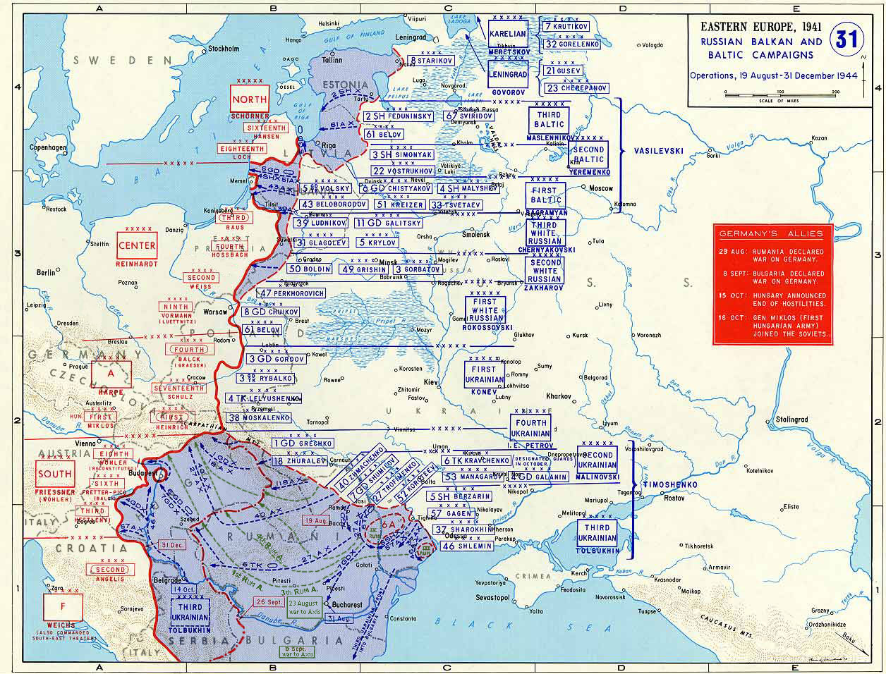
Taken from the campaign series, made public by the US-Army under www.dean.usma.edu The picture is public domain. It shows the situation of the Easter Front from 13. Aug. '44 until 31. Dec. '44
- Source: dean.usma.edu archive copy at the Wayback Machine
From website:
- In 1938 the predecessors of what is today The Department of History at the United States Military Academy began developing a series of campaign atlases to aid in teaching cadets a course entitled, "History of the Military Art." Since then, the Department has produced over six atlases and more than one thousand maps, encompassing not only America’s wars but global conflicts as well.
- In keeping abreast with today's technology, the Department of History is providing these maps on the internet as part of the department's outreach program. The maps were created by the United States Military Academy’s Department of History and are the digital versions from the atlases printed by the United States Defense Printing Agency. We gratefully acknowledge the accomplishments of the department's former cartographer, Mr. Edward J. Krasnoborski, along with the works of our present cartographer, Mr. Frank Martini.
- Please be aware that these maps are large in file size and may require substantial download times.
Це зображення є роботою працівника чи військовослужбовця Армії США, зробленою чи сфотографованою ним як частина його обов'язків. Як робота Федерального уряду США, це зображення перебуває в суспільному надбанні в США.
|
 |

|
Ця мапа має бути конвертована у векторний формат SVG. Це дає декілька переваг, докладніше про які Ви можете прочитати на сторінці Commons:Media for cleanup. Якщо Вам вже зараз доступна векторна версія даного зображення, завантажте її, будь ласка. Після завантаження замініть цей шаблон на такий: {{vector version available|Назва_завантаженого_файлу.svg}}.
|


Історія файлу
Клацніть на дату/час, щоб переглянути, як тоді виглядав файл.
| Дата/час | Мініатюра | Розмір об'єкта | Користувач | Коментар | |
|---|---|---|---|---|---|
| поточний | 18:47, 12 січня 2015 | | 1256 × 956 (531 КБ) | Spiridon Ion Cepleanu | Borders of years 1940-1944 (rectified some little mistakes) |
| 10:52, 22 квітня 2007 |  | 1256 × 956 (203 КБ) | Nasiruddin | Taken from the campaign series, made public by the US-Army under www.dean.usma.edu The picture is public domain. It shows the situation of the Easter Front from 13. Aug. '44 until 31. Dec. '44 *Source: [http://www.dean.usma.edu/history/web03/atlases/grea |
Використання файлу
Такі сторінки використовують цей файл:
Глобальне використання файлу
Цей файл використовують такі інші вікі:
- Використання в ar.wikipedia.org
- Використання в ca.wikipedia.org
- Використання в cs.wikipedia.org
- Використання в de.wikipedia.org
- Використання в el.wikipedia.org
- Використання в en.wikipedia.org
- Використання в es.wikipedia.org
- Використання в et.wikipedia.org
- Використання в fr.wikipedia.org
- Використання в he.wikipedia.org
- Використання в id.wikipedia.org
- Використання в it.wikipedia.org
- Використання в ja.wikipedia.org
- Використання в nl.wikipedia.org
- Використання в pl.wikipedia.org
- Використання в pnb.wikipedia.org
- Використання в ro.wikipedia.org
- Використання в ru.wikipedia.org
- Використання в sh.wikipedia.org
- Використання в sr.wikipedia.org
Переглянути сторінку глобального використання цього файлу.