Файл:USA Territorial Growth 1850.jpg

Повна роздільність (1400 × 616 пікселів, розмір файлу: 124 КБ, MIME-тип: image/jpeg)
| Відомості про цей файл містяться на Вікісховищі — централізованому сховищі вільних файлів мультимедіа для використання у проектах Фонду Вікімедіа. |
| US growth maps |
| Animated: large · small |
| Years |
| 1775 · 1790 · 1800 · 1810 · 1820 · 1830 · 1840 · 1850 · 1860 · 1870 · 1880 · 1900 · 1920 |
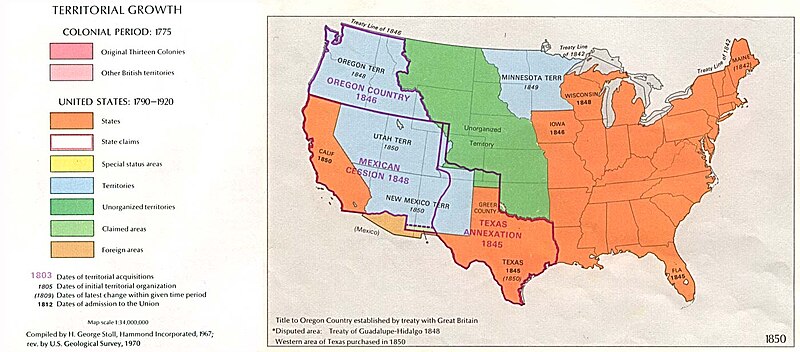
Map of U.S. Territorial Growth (1850) from the Perry-Castañeda Library Map Collection, "...the maps scanned by the University of Texas Libraries and served from this web site are in the public domain. No permissions are needed to copy them. You may download them and use them as you wish."
This image can be found at U.S. Territorial Growth 1850.
"Courtesy of the University of Texas Libraries, The University of Texas at Austin."
Other versions: 
|
Ця робота перебуває у суспільному надбанні у країнах і територіях, де авторське право охороняється протягом життя автора та 70 років після того або менше.
| |
| Цей файл визнано вільним від відомих обмежень з боку закону про авторські права, включаючи всі пов'язані і суміжні права. | |
Історія файлу
Клацніть на дату/час, щоб переглянути, як тоді виглядав файл.
| Дата/час | Мініатюра | Розмір об'єкта | Користувач | Коментар | |
|---|---|---|---|---|---|
| поточний | 06:18, 4 жовтня 2005 | | 1400 × 616 (124 КБ) | Lordkinbote~commonswiki | Map of U.S. Territorial Growth (1850) from the Perry-Castañeda Library Map Collection. This image can be found at [http://www.lib.utexas.edu/maps/united_states/us_terr_1850.jpg]. |
Використання файлу
Така сторінка використовує цей файл:
Глобальне використання файлу
Цей файл використовують такі інші вікі:
- Використання в ca.wikipedia.org
- Використання в de.wikipedia.org
- Використання в en.wikipedia.org
- Використання в es.wikinews.org
- Використання в hy.wikipedia.org
- Використання в it.wikipedia.org
- Використання в ja.wikipedia.org
- Використання в la.wikipedia.org
- Використання в nl.wikipedia.org
- Використання в no.wikipedia.org
- Використання в pl.wikipedia.org
- Використання в pt.wikipedia.org
- Використання в ro.wikipedia.org
- Використання в ru.wikipedia.org
- Використання в simple.wikipedia.org