Файл:World map of countries by ecological footprint (2007).svg
Перейти до навігації
Перейти до пошуку

Розмір цього попереднього перегляду PNG для вихідного SVG-файлу: 800 × 353 пікселів. Інші роздільності: 320 × 141 пікселів | 640 × 283 пікселів | 1024 × 452 пікселів | 1280 × 565 пікселів | 2560 × 1130 пікселів | 940 × 415 пікселів.
Повна роздільність (SVG-файл, номінально 940 × 415 пікселів, розмір файлу: 1,36 МБ)
| Відомості про цей файл містяться на Вікісховищі — централізованому сховищі вільних файлів мультимедіа для використання у проектах Фонду Вікімедіа. |
Опис файлу
| Опис |
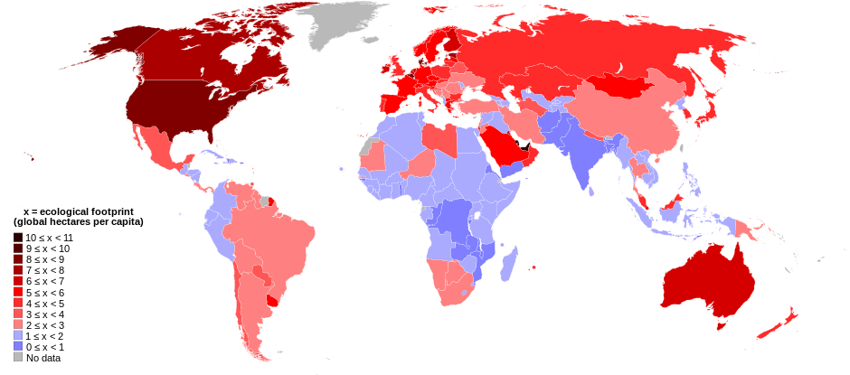
English: World map of countries shaded according to their ecological footprint in 2007 (published on 13 October 2010 by the Global Footprint Network). It is measured by the amount of global hectares that are affected by humans per capita of the country. Lighter shades denote countries with a lower ecological footprint per capita and darker shaded for countries with a higher ecological footprint per capita. The total ecological footprint (global hectares affected by humans) is measured as a total of six factors: cropland footprint, grazing footprint, forest footprint, fishing ground footprint, carbon footprint and built-up land.
Français : Mapemonde colorée selon l'empreinte écologique moyenne des habitants de chaque pays, exprimée en ha par personne, en 2007. Le tons plus chairs correspondent à une empreinte faible, les tons plus sombres à une empreinte plus forte. Six facteurs sont pris en compte pour mesurer cette empreinte: L'agriculture, le pâturage, l'exploitation forestière, la pêche, la production de carbone et l'urbanisation.
No data
0 ≤ x < 1
1 ≤ x < 2
2 ≤ x < 3
3 ≤ x < 4
4 ≤ x < 5
5 ≤ x < 6
6 ≤ x < 1
7 ≤ x < 8
8 ≤ x < 9
9 ≤ x < 10
10 ≤ x < 11 |
| Час створення | |
| Джерело | Self-made with data from list of countries by ecological footprint. |
| Автор | Jolly Janner |
| Інші версії |
|


.svg)
Ліцензування
| Я, власник авторських прав на цю роботу, передаю роботу в суспільне надбання. Застосовується по всьому світу. У деяких країнах це не може бути юридично можливо, в такому випадку: Я даю кожному право на використання цієї роботи для будь-яких цілей, без будь-яких умов, якщо такі умови не вимагаються за законом. |
Історія файлу
Клацніть на дату/час, щоб переглянути, як тоді виглядав файл.
| Дата/час | Мініатюра | Розмір об'єкта | Користувач | Коментар | |
|---|---|---|---|---|---|
| поточний | 01:24, 30 березня 2018 | | 940 × 415 (1,36 МБ) | Sisgeo | Employ a different color for countries under 2.1 gHa, the estimated limit of sustainability. |
| 18:44, 29 жовтня 2010 |  | 940 × 415 (1,68 МБ) | Jolly Janner | Added a white box to represent the background | |
| 18:38, 29 жовтня 2010 |  | 940 × 415 (1,68 МБ) | Jolly Janner | white background | |
| 18:36, 29 жовтня 2010 |  | 940 × 415 (1,68 МБ) | Jolly Janner | white background | |
| 18:24, 29 жовтня 2010 |  | 940 × 415 (1,68 МБ) | Jolly Janner | == {{int:filedesc}} == {{Information |Description={{en|1=World map of countries shaded according to their ecological footprint in 2007 (published on 13 October 2010 by the Global Footprint Network). It is measured by the amoun |
Використання файлу
Така сторінка використовує цей файл:
Глобальне використання файлу
Цей файл використовують такі інші вікі:
- Використання в ca.wikipedia.org
- Використання в el.wikipedia.org
- Використання в en.wikipedia.org
- Використання в en.wikibooks.org
- Використання в eu.wikipedia.org
- Використання в fa.wikipedia.org
- Використання в fr.wikipedia.org
- Використання в gl.wikipedia.org
- Використання в hi.wikipedia.org
- Використання в it.wikipedia.org
- Використання в ms.wikipedia.org
- Використання в nl.wikipedia.org
- Використання в pl.wikipedia.org
- Використання в pl.wikibooks.org
- Використання в ro.wikipedia.org
- Використання в sk.wikipedia.org
- Використання в sr.wikipedia.org
- Використання в ta.wikipedia.org
- Використання в zh.wikipedia.org
.svg)