Файл:Armenia - Location Map (2013) - ARM - UNOCHA.svg

Повна роздільність (SVG-файл, номінально 250 × 250 пікселів, розмір файлу: 713 КБ)
| Відомості про цей файл містяться на Вікісховищі — централізованому сховищі вільних файлів мультимедіа для використання у проектах Фонду Вікімедіа. |
_-_ARM_-_UNOCHA.svg)
Опис файлу
| Опис |
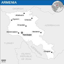
English: Locator map of Armenia. |
| Час створення | |
| Джерело |
English: Armenia Locator Map (ReliefWeb), ESRI, UNCS |
| Автор | |
| SVG розвиток |
Ліцензування
- Ви можете вільно:
- ділитися – копіювати, поширювати і передавати твір
- модифікувати – переробляти твір
- При дотриманні таких умов:
- зазначення авторства – Ви повинні вказати авторство, надати посилання на ліцензію і вказати, чи якісь зміни було внесено до оригінального твору. Ви можете зробити це в будь-який розсудливий спосіб, але так, щоб він жодним чином не натякав на те, наче ліцензіар підтримує Вас чи Ваш спосіб використання твору.
 This map is part of a collection of 216 free country maps, created by the UN Office for the Coordination of Humanitarian Affairs (OCHA), to be used in print, web or broadcast products.
The ReliefWeb Location Maps released here are maps that highlight a country, its capital, major populated places and the surrounding regions. Attribution Requirements
Using the map without modifications: ensure that the sources and the disclaimer are below the map. Credit as follows: "Credit: OCHA". For use with alteration: remove the OCHA logo and disclaimer following any modification to the map, but keep the data sources as mentioned below the map. Credit the modified map as follows: "Based on OCHA map". You are responsible for the content of your map. We are keen to receive your feedback and hear how you used OCHA's maps. We would be grateful if you would notify us by e-mail and share your work with us. UN Disclaimer
The designations employed and the presentation of material of this map do not imply the expression of any opinion whatsoever on the part of the Secretariat of the United Nations concerning the legal status of any country, territory, city or area or of its authorities or concerning the delimitation of its frontiers or boundaries. |

|
Textual information (e.g. timestamp) once visible in the image itself has been moved into the image metadata and/or image description page. This makes the image easier to reuse and more language-neutral, and makes the text easier to process and search for. Commons discourages placing visible textual information in images. All licenses accepted on Commons permit this type of modification as a derivative work.
If attribution information were removed and the image is not public domain, replace this tag with {{Attribution metadata from licensed image}}.
|
Історія файлу
Клацніть на дату/час, щоб переглянути, як тоді виглядав файл.
| Дата/час | Мініатюра | Розмір об'єкта | Користувач | Коментар | |
|---|---|---|---|---|---|
| поточний | 01:50, 23 грудня 2022 | | 250 × 250 (713 КБ) | Wikijahnn | File uploaded using svgtranslate tool (https://svgtranslate.toolforge.org/). Added translation for ca. |
| 13:34, 9 березня 2022 |  | 250 × 250 (711 КБ) | Nyilvoskt | File uploaded using svgtranslate tool (https://svgtranslate.toolforge.org/). Added translation for id. | |
| 20:43, 5 січня 2016 |  | 250 × 250 (709 КБ) | Wereldburger758 | Resized page to drawing. Removal watermark. Validation of image. | |
| 20:46, 24 лютого 2014 |  | 254 × 254 (715 КБ) | Jeremyb | xslt v2b | |
| 20:41, 10 лютого 2014 |  | 250 × 250 (1,73 МБ) | Pharos | {{Information |description={{en|1=Locator Map of Armenia. {{OCHA map}}}} |date=February 2014 |source=UN Office for the Coordination of Humanitarian Affairs (OCHA) |author=[[w:Unit... |
Використання файлу
Така сторінка використовує цей файл:
Глобальне використання файлу
Цей файл використовують такі інші вікі:
- Використання в az.wikipedia.org
- Використання в ca.wikipedia.org
- Використання в en.wikipedia.org
- Використання в es.wikipedia.org
- Використання в fr.wikipedia.org
- Використання в gor.wikipedia.org
- Використання в id.wikipedia.org
- Використання в ru.wikipedia.org
- Використання в sat.wikipedia.org
- Використання в so.wikipedia.org
- Використання в ts.wikipedia.org
_-_ARM_-_UNOCHA.svg)