Файл:Taupo.Volcanic.Zone.North.Island.NZ.JPG
Повна роздільність (616 × 864 пікселів, розмір файлу: 104 КБ, MIME-тип: image/jpeg)
| Відомості про цей файл містяться на Вікісховищі — централізованому сховищі вільних файлів мультимедіа для використання у проектах Фонду Вікімедіа. |
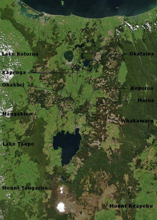
| Опис | Bay of Plenty, North Island, New Zealand, from the Bay of Plenty coast to Mounts Tongariro, Ngauruhoe, and Ruapehu (at bottom of picture). Also shows Lake Taupo and the Rotorua Lakes. This scene was acquired by the Moderate Resolution Imaging Spectroradiometer (MODIS), flying aboard NASA’s Terra satellite, on October 23, 2002 |
| Час створення | (UTC) |
| Джерело | |
| Автор |
|
Annotations based on: Hiess J, Cole JW, Spinks KD (2007), High-Alumina Basalts of the Taupo Volcanic Zone, New Zealand: Influence of the Crust and Crustal Structure [1]; Krippner SJP, Briggs RM, Wilson CJN, Cole JW (1998), Petrography and geochemistry of lithic fragments in ignimbrites from the Mangakino Volcanic Centre: implications for the composition of the subvolcanic crust in western Taupo Volcanic Zone, New Zealand; New Zealand Journal of Geology and Geophysics, Vol. 41: 187-199 [2] archive copy at the Wayback Machine; Newhall, Christopher G.; Dzurisin, Daniel (1988), Historical unrest at large calderas of the world, USGS Bulletin 1855, p. 1108 [3] archive copy at the Wayback Machine; Siebert L, Simkin T (2002-), Volcanoes of the World: an Illustrated Catalog of Holocene Volcanoes and their Eruptions, Smithsonian Institution, Global Volcanism Program Digital Information Series, GVP-3 [4]
| Цей файл перебуває у суспільному надбанні, оскільки він був створений NASA (Національним управлінням з аеронавтики і дослідження космічного простору). Згідно з політикою NASA стосовно авторського права, «матеріали NASA не захищаються авторським правом, якщо не вказано протилежне». (Див. Template:PD-USGov, сторінку політики NASA стосовно авторського права, або політику використання зображень JPL.) | ||
 |
Попередження:
|
Журнал завантажень локального файлу
This image is a derivative work of the following images:
- File:BayofPlentyA2002296.jpg licensed with PD-USGov-NASA
- 2007-08-24T00:20:45Z Kahuroa 616x864 (505144 Bytes) == Summary == {{Information |Description=Bay of Plenty, North Island, New Zealand, from the Bay of Plenty coast to Mounts Tongariro, Ngauruhoe, and Ruapehu (at bottom of picture). Also shows Lake Taupo and the Rotorua Lakes.
Uploaded with derivativeFX
Історія файлу
Клацніть на дату/час, щоб переглянути, як тоді виглядав файл.
| Дата/час | Мініатюра | Розмір об'єкта | Користувач | Коментар | |
|---|---|---|---|---|---|
| поточний | 02:17, 20 лютого 2010 | | 616 × 864 (104 КБ) | Chris.urs-o | One label was missing. |
| 01:49, 20 лютого 2010 |  | 616 × 864 (103 КБ) | Chris.urs-o | Fixed label | |
| 10:42, 19 лютого 2010 |  | 616 × 864 (105 КБ) | Chris.urs-o | Improved caldera locations | |
| 11:20, 18 лютого 2010 |  | 616 × 864 (103 КБ) | Chris.urs-o | {{Information |Description=Bay of Plenty, North Island, New Zealand, from the Bay of Plenty coast to Mounts Tongariro, Ngauruhoe, and Ruapehu (at bottom of picture). Also shows Lake Taupo and the Rotorua Lakes. This scene was acquired by the Moderate Reso |
Використання файлу
Така сторінка використовує цей файл:
Глобальне використання файлу
Цей файл використовують такі інші вікі:
- Використання в ar.wikipedia.org
- Використання в de.wikipedia.org
- Використання в en.wikipedia.org
- Використання в en.wikiversity.org
- Використання в es.wikipedia.org
- Використання в fi.wikipedia.org
- Використання в id.wikipedia.org
- Використання в it.wikipedia.org
- Використання в mk.wikipedia.org
- Використання в ru.wikipedia.org
- Використання в simple.wikipedia.org
- Використання в sl.wikipedia.org