Файл:Conquest mexico 1519 21.png
Перейти до навігації
Перейти до пошуку

Розмір при попередньому перегляді: 800 × 399 пікселів. Інші роздільності: 320 × 160 пікселів | 640 × 320 пікселів | 1300 × 649 пікселів.
Повна роздільність (1300 × 649 пікселів, розмір файлу: 1,45 МБ, MIME-тип: image/png)
| Відомості про цей файл містяться на Вікісховищі — централізованому сховищі вільних файлів мультимедіа для використання в проектах Фонду Вікімедіа. |
Опис файлу

|
Цей файл було замінено на файл File:Ruta de Cortés.svg. Рекомендовано використовувати той файл. Пам'ятайте, що вилучення замінених зображень потребує обговорення. Умови використання іншого файлу: "The source of that other map is more recent and reliable."
|
| Опис |
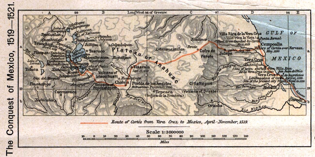
English: The 1519 to 1521 route of the Spanish conquest of the Aztec Empire — taken in Central Mexico by Hernando Cortés.
Français : La route de la conquête espagnole de l'Empire aztèque au centre de Mexique, comme suivi par Hernán Cortés de 1519 à 1521 |
| Час створення | |
| Джерело |
English: Scan from Historical Atlas by William R. Shepherd, New York, Henry Holt and Company, 1926 ed. Original image at the Perry-Castañeda Library Map Collection at the en:University of Texas at Austin website: http://www.lib.utexas.edu/maps/historical/shepherd/conquest_mexico_1519_21.jpg |
| Автор | William R. Shepherd |
| Ліцензія (Повторне використання цього файлу) |
English: From the FAQ @ http://www.lib.utexas.edu/maps/faq.html
|
| Інші версії |
|

Ліцензування
This file may not have the correct information on its copyright status.
Notify the uploader with:
Items tagged with this template are sorted into Category:Items with disputed copyright information.
|
Цей файл перебуває в суспільному надбанні в США. Це стосується робіт, опублікованих в США, термін дії авторського права який сплинув, оскільки вони були опубліковані до 1 січня 1929. Див. тут для подробиць.
|
 | |
 |
Журнал завантажень локального файлу
Оригінальна сторінка опису знаходилась тут. Усі нижчезазначені імена користувачів стосуються en.wikipedia.
- 2006-12-18 21:20 Jengod 1300×649×8 (1520705 bytes) Scan from "Historical Atlas" by William R. Shepherd, New York, Henry Holt and Company, 1926 ed. Original image at the [http://www.lib.utexas.edu/maps/ Perry-Castañeda Library Map Collection] at the [[University of Texas at Austin]] website: http://www.l
Історія файлу
Клацніть на дату/час, щоб переглянути, як тоді виглядав файл.
| Дата/час | Мініатюра | Розмір об'єкта | Користувач | Коментар | |
|---|---|---|---|---|---|
| поточний | 20:12, 17 квітня 2008 | | 1300 × 649 (1,45 МБ) | File Upload Bot (Magnus Manske) | {{BotMoveToCommons|en.wikipedia}} {{Information |Description={{en|Scan from "Historical Atlas" by William R. Shepherd, New York, Henry Holt and Company, 1926 ed. Original image at the [http://www.lib.utexas.edu/maps/ Perry-Castañeda Library Map Collect |
Використання файлу
Така сторінка використовує цей файл:
Глобальне використання файлу
Цей файл використовують такі інші вікі:
- Використання в azb.wikipedia.org
- Використання в ca.wikipedia.org
- Використання в cs.wikipedia.org
- Використання в en.wikipedia.org
- Використання в es.wikipedia.org
- Використання в fa.wikipedia.org
- Використання в ja.wikipedia.org
- Використання в ms.wikipedia.org
- Використання в pnb.wikipedia.org
- Використання в sl.wikipedia.org
- Використання в th.wikipedia.org
- Використання в tr.wikipedia.org
- Використання в ur.wikipedia.org
- Використання в vi.wikipedia.org
- Використання в www.wikidata.org