Файл:Finland-Norway border map.png
Перейти до навігації
Перейти до пошуку
Нема версії з більшою роздільністю.
Finland-Norway_border_map.png (514 × 290 пікселів, розмір файлу: 93 КБ, MIME-тип: image/png)
| Відомості про цей файл містяться на Вікісховищі — централізованому сховищі вільних файлів мультимедіа для використання у проектах Фонду Вікімедіа. |
Опис файлу
| Опис |
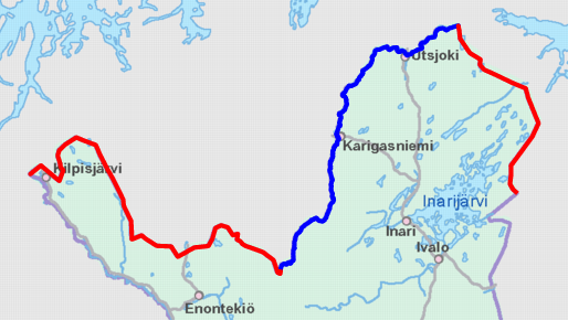
English: Schematic map of the Finland–Norway border. Land border highlighted in red and river border in blue.
Map cropped from the 1:4000000 background map provided by the NLS of Finland. Highlighted border is based on free numeric data provided by the NLS. Suomi: Karttakuva Suomen ja Norjan rajasta. Maaraja korostettu punaisella ja jokiraja sinisellä.
Karttapohja on otettu Maanmittauslaitoksen 1:4000000 taustakartasta, johon on lisätty värikorostus Maanmittauslaitoksen numeerisen aineiston avulla. |
| Час створення | |
| Джерело | https://tiedostopalvelu.maanmittauslaitos.fi/tp/kartta?lang=en |
| Автор | National Land Survey of Finland; color highlights added by Jmk |
Ліцензування

|
This file is licensed under the National Land Survey open data licence, version 1.0 (1 May 2012) published by the National Land Survey of Finland.
You are free to:
You must, through reasonable means:
The terms of this licence do not allow you to state in conjunction with the use of dataset(s) that the NLS supports or recommends such use. |
 |
| Зазначення авторства: contains map data from the National Land Survey of Finland Topographic Database 09/2012
|
Історія файлу
Клацніть на дату/час, щоб переглянути, як тоді виглядав файл.
| Дата/час | Мініатюра | Розмір об'єкта | Користувач | Коментар | |
|---|---|---|---|---|---|
| поточний | 10:12, 9 листопада 2012 | | 514 × 290 (93 КБ) | Jmk | User created page with UploadWizard |
Використання файлу
Така сторінка використовує цей файл:
Глобальне використання файлу
Цей файл використовують такі інші вікі:
- Використання в ckb.wikipedia.org
- Використання в cs.wikipedia.org
- Використання в de.wikipedia.org
- Використання в en.wikipedia.org
- Використання в es.wikipedia.org
- Використання в fi.wikipedia.org
- Використання в fi.wiktionary.org
- Використання в hr.wikipedia.org
- Використання в it.wikipedia.org
- Використання в sv.wikipedia.org