Файл:Irene Aug 24 2011 1810Z.jpg

Повна роздільність (6400 × 8200 пікселів, розмір файлу: 25,48 МБ, MIME-тип: image/jpeg)
| Відомості про цей файл містяться на Вікісховищі — централізованому сховищі вільних файлів мультимедіа для використання у проектах Фонду Вікімедіа. |
| Попередження | У деяких браузерах можуть виникнути проблеми при перегляді цього зображення у повній роздільності: це зображення має дуже велику кількість пікселів і може завантажитись зі спотвореннями, або спричинити зависання браузера. |
|---|
Опис файлу
| Опис |
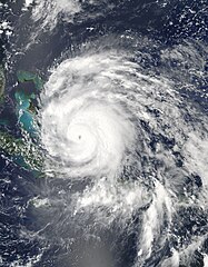
English: Hurricane Irene strengthened on its path toward the continental United States in late August 2011. Residents of the U.S. East Coast braced for the first hurricane to seriously threaten the country in three years, Voice of America reported.
The Moderate Resolution Imaging Spectroradiometer (MODIS) on NASA’s Aqua satellite captured this natural-color image at 2:15 p.m. local time (18:15 UTC) on August 24. Storm clouds hide the Turks and Caicos Islands, and extend westward over The Bahamas. Clouds also linger over the Dominican Republic and Haiti. At 2:00 p.m. Eastern Daylight Time on August 24, about the time MODIS took this picture, the U.S. National Hurricane Center (NHC) reported that Irene was a Category 3 hurricane with maximum sustained winds of 120 miles (195 kilometers) per hour. By 5:00 a.m. EDT on August 25, the NHC reported, Irene’s winds had weakened slightly, to 115 miles (185 kilometers) per hour. The storm remained a powerful Category 3 hurricane. A hurricane warning was in effect for the southeastern, central, and northwestern Bahamas. A hurricane watch was in effect for Surf City, North Carolina, northward to the Virginia border. A tropical storm watch was in effect for Edisto Beach, South Carolina, north to Surf City. As of 5:00 a.m. EDT on August 25, Irene was moving toward the northwest at about 12 miles (19 kilometers) per hour. The storm was expected to turn toward the north-northwest the same day, then toward the north early the following day. The NHC five-day storm track showed Irene moving northward along the U.S. East Coast. As U.S. residents braced for Irene’s arrival, residents of Caribbean Islands cleaned up from the destructive storm. The Christian Science Monitor reported that flooding and mudslides had forced the Dominican Republic to evacuate nearly 38,000 people, and a U.S.-based analysis firm estimated potential damage in the Caribbean at up to $3.1 billion. |
| Час створення | |
| Джерело | http://earthobservatory.nasa.gov/NaturalHazards/view.php?id=51867 |
| Автор | NASA image courtesy Jeff Schmaltz, MODIS Rapid Response, NASA Goddard Space Flight Center. Caption by Michon Scott. |
Ліцензування
| Цей файл перебуває у суспільному надбанні, оскільки він був створений NASA (Національним управлінням з аеронавтики і дослідження космічного простору). Згідно з політикою NASA стосовно авторського права, «матеріали NASA не захищаються авторським правом, якщо не вказано протилежне». (Див. Template:PD-USGov, сторінку політики NASA стосовно авторського права, або політику використання зображень JPL.) | ||
 |
Попередження:
|
Історія файлу
Клацніть на дату/час, щоб переглянути, як тоді виглядав файл.
| Дата/час | Мініатюра | Розмір об'єкта | Користувач | Коментар | |
|---|---|---|---|---|---|
| поточний | 06:49, 29 жовтня 2019 | | 6400 × 8200 (25,48 МБ) | Nino Marakot | Reverted to version as of 22:50, 29 July 2013 (UTC) - Reverting to final re-upload by Supportstorm |
| 23:26, 15 квітня 2018 |  | 8232 × 9737 (55,25 МБ) | MarioProtIV | Reverted to version as of 02:33, 14 November 2012 (UTC) | |
| 23:07, 29 березня 2018 |  | 1400 × 1700 (402 КБ) | CooperScience | Centering image | |
| 22:50, 29 липня 2013 |  | 6400 × 8200 (25,48 МБ) | Supportstorm | Gallery version | |
| 02:33, 14 листопада 2012 |  | 8232 × 9737 (55,25 МБ) | Supportstorm | HDF File Quality Image | |
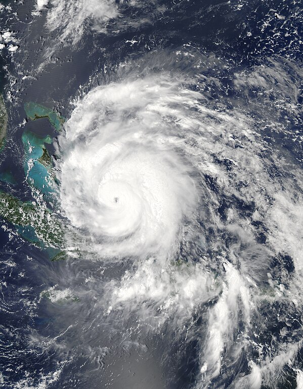
| 21:36, 24 серпня 2011 |  | 6620 × 6620 (6,45 МБ) | Supportstorm | {{Information |Description ={{en|1=Major Hurricane Irene on August 24, 2011 as a category three.}} |Source =http://lance-modis.eosdis.nasa.gov/wms/?zoom=3&lat=21.75&lon=-16.18359&layers=000B0FFFFFFT&datum1=08/24/2011 |Author =NASA, MODI |
Використання файлу
Така сторінка використовує цей файл:
Глобальне використання файлу
Цей файл використовують такі інші вікі:
- Використання в ar.wikipedia.org
- Використання в de.wikipedia.org
- Використання в en.wikipedia.org
- Використання в eo.wikipedia.org
- Використання в es.wikipedia.org
- Використання в es.wikinews.org
- Використання в eu.wikipedia.org
- Використання в fa.wikipedia.org
- Використання в fi.wikipedia.org
- Використання в fr.wikipedia.org
- Використання в hi.wikipedia.org
- Використання в id.wikipedia.org
- Використання в is.wikipedia.org
- Використання в it.wikipedia.org
- Використання в ja.wikipedia.org
- Використання в jv.wikipedia.org
- Використання в ko.wikipedia.org
- Використання в ms.wikipedia.org
- Використання в nl.wikipedia.org
- Використання в pl.wikipedia.org
- Використання в pt.wikipedia.org
- Використання в ro.wikipedia.org
- Використання в ru.wikipedia.org
- Використання в ru.wikinews.org
- Використання в simple.wikipedia.org
- Використання в ta.wikipedia.org
- Використання в th.wikipedia.org
- Використання в vi.wikipedia.org
- Використання в www.wikidata.org
- Використання в zh.wikipedia.org