Файл:Marius hills pit.png
Перейти до навігації
Перейти до пошуку

Розмір при попередньому перегляді: 800 × 508 пікселів. Інші роздільності: 320 × 203 пікселів | 640 × 406 пікселів | 1024 × 650 пікселів | 1430 × 908 пікселів.
Повна роздільність (1430 × 908 пікселів, розмір файлу: 746 КБ, MIME-тип: image/png)
| Відомості про цей файл містяться на Вікісховищі — централізованому сховищі вільних файлів мультимедіа для використання у проектах Фонду Вікімедіа. |
Опис файлу
| Опис |
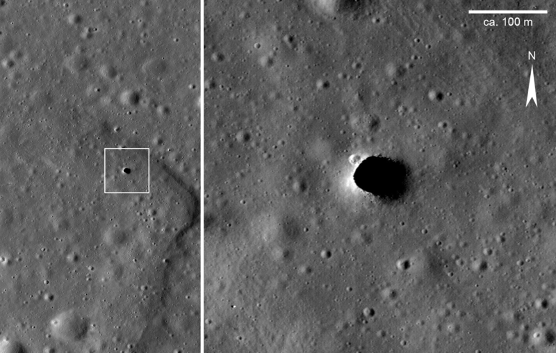
English: Photograph of a ‘hole’ in the Moon’s surface in the Marius Hills area, Oceanus Procellarum, taken by the Lunar Reconnaissance Orbiter probe (LRO). The right image renders a magnification of the area which is enclosed in the white box in the left image. In the left image the situation of the ‘hole’ within a shallow, sinuous rille structure (rima) is well recognizable. Because rilles are thought to represent fossil lava streams, the ‘hole’ is interpreted as a skylight of a lava tube (cf. Haruyama et al., 2009[1]). The Marius Hill hole is the first such feature ever spotted on Moon. The scale bar is according to the image being about 900 pixels wide with a pixel covering about 0.5×0.5 m of the Moon’s surface. Deutsch: Foto eines ‚Lochs‘ in der Oberfläche des Mondes in der Marius-Hills-Region, Oceanus Procellarum, aufgenommen von der Lunar-Reconnaissance-Orbiter-Sonde (LRO). Das rechte Bild ist eine Vergrößerung der im linken Bild weiß eingekästelten Region. Im linken Bild ist die Lage des ‚Lochs‘ in einer flachen, gewundenen Mondrille (Rima) gut erkennbar. Weil Mondrillen als fossile Lavaflüsse gelten, wird das ‚Loch‘ als sogenanntes Skylight, die partiell eingestürzte Decke einer Lavaröhre, interpretiert (vgl. Haruyama et al., 2009[1]). Das ‚Loch‘ in den Marius Hills ist die erste derartige Struktur, die je auf dem Mond entdeckt wurde. Der Maßstabsbalken richtet sich danach, dass das Bild rund 900 Pixel breit ist, wobei ein Pixel etwa 0,5×0,5 m Mondoberfläche abdeckt.
|
| Час створення | |
| Джерело | Extracted and modified from CDR PTIF file downloaded at LROC Data Node of the NASA Planetary Data System; URL to download page is http://wms.lroc.asu.edu/lroc/view_lroc/LRO-L-LROC-2-EDR-V1.0/M114328462RE |
| Автор | NASA/Lunar Reconnaissance Orbiter Camera (LROC) Science Operations Center (SOC) team at Arizona State University |
Ліцензування
| Цей файл перебуває у суспільному надбанні, оскільки він був створений NASA (Національним управлінням з аеронавтики і дослідження космічного простору). Згідно з політикою NASA стосовно авторського права, «матеріали NASA не захищаються авторським правом, якщо не вказано протилежне». (Див. Template:PD-USGov, сторінку політики NASA стосовно авторського права, або політику використання зображень JPL.) | ||
 |
Попередження:
|
Історія файлу
Клацніть на дату/час, щоб переглянути, як тоді виглядав файл.
| Дата/час | Мініатюра | Розмір об'єкта | Користувач | Коментар | |
|---|---|---|---|---|---|
| поточний | 22:28, 1 листопада 2018 | | 1430 × 908 (746 КБ) | Gretarsson | {{Information |description ={{en|1=Photograph of a ‘hole’ in the Moon’s surface in the Marius Hills area, Oceanus Procellarum, taken by the Lunar Reconnaissance Orbiter probe (LROC). The right image renders a magnification of the area which is enclosed in the white box in the left image. In the left image the situation of the ‘hole’ within a shallow, sinous rille structure (rima) is well recognizable. Because rilles are thought to represent fossil lava streams, the ‘hole’ is interpreted as... |
Використання файлу
Така сторінка використовує цей файл:
Глобальне використання файлу
Цей файл використовують такі інші вікі:
- Використання в de.wikipedia.org
- Використання в en.wikipedia.org
- Використання в ru.wikipedia.org
- Використання в zh.wikipedia.org