Файл:Notre-Dame de Paris composite transverse section.svg

Матеріал з Вікіпедії — вільної енциклопедії.
Перейти до навігації Перейти до пошуку

Повна роздільність (SVG-файл, номінально 856 × 1494 пікселів, розмір файлу: 407 КБ)

Опис файлу

Опис
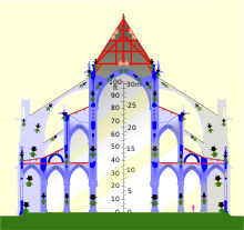
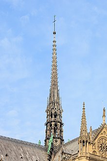
English: Composite transverse section of Notre-Dame de Paris before the 2019 fire. Timber framework in red, masonry in blues, metal in grey. Left, a tower, showing internal framework of belfry (bells not shown). Center, nave, covered by masonry vault and 55-degree triangular roof (spire shown above and behind). Right, side aisles, triforium aisle above, flying buttresses. Note that the vaults thrust outwards on the walls, and the flying buttresses thrust inwards; unless these two forces balance, the wall will be pushed over. Black arrows show the force of the weight of the structure being transmitted to the ground; green arrows show the upwards force of the ground supporting the structure. Orange and grey arrows show the forces in the wood and metal of the roof trusses. Roof trusses cancel out their outwards forces using internal tension (masonry cannot support tension). Light added for clarity.
Час створення
Джерело Own work, derived as indicated under "authors"
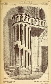
Автор Own work, traced from public domain File:Notre Dame 531 transverse crop rot.jpg and heavily altered, mostly using the public domain architectural drawings of Eugène Viollet-le-Duc (see particularly Category:Frame of Notre-Dame de Paris). The public-domain image File:Materials and documents of architecture and sculpture - classified alphabetically (1915) (14587788087).jpg was used for the stair. Photos were also used to verify details; thanks to all Commons contributors who took unconventional shots.
Інші версії
non-composite cross-section
Місцеположення камери48° 51′ 10,8″ пн. ш., 2° 20′ 59,28″ сх. д.  Heading=135° Kartographer map based on OpenStreetMap.Перегляньте це та інші зображення поблизу на: OpenStreetMapinfo

Please note that this is not a finite element analysis, nor yet an architectural drawing; it's an infographic. That said, corrections are welcome. There are probably errors; I honestly have no good data on the space between the the vaults and the floors, for instance, and no idea if the area between the towers is even flat. I've made guesses, which I hope are sensible ones. The crypt, foundations, and staircase in the belfry framing are not shows due to lack of data. The North tower is shown with the framing of the south tower, due to a lack of an elevation of the latter. There are eight bells in the north tower, but from this perspective four bells are hiding behind the other four. I do not know which bells are larger and have not attempted to show the size range.

Ліцензування

w:uk:Creative Commons
зазначення авторства поширення на тих же умовах
Ви можете вільно:
  • ділитися – копіювати, поширювати і передавати твір
  • модифікувати – переробляти твір
При дотриманні таких умов:
  • зазначення авторства – Ви повинні вказати авторство, надати посилання на ліцензію і вказати, чи якісь зміни було внесено до оригінального твору. Ви можете зробити це в будь-який розсудливий спосіб, але так, щоб він жодним чином не натякав на те, наче ліцензіар підтримує Вас чи Ваш спосіб використання твору.
  • поширення на тих же умовах – Якщо ви змінюєте, перетворюєте або створюєте іншу похідну роботу на основі цього твору, ви можете поширювати отриманий у результаті твір тільки на умовах такої ж або сумісної ліцензії.
Анотації
InfoField
Це зображення має анотації: Переглянути анотації на Вікісховищі

Підписи

Додайте однорядкове пояснення, що саме репрезентує цей файл
Composite transverse section of Notre-Dame de Paris

Об'єкти, показані на цьому файлі

зображує

48°51'10.8"N, 2°20'59.3"E

азимут: 135 градус

Історія файлу

Клацніть на дату/час, щоб переглянути, як тоді виглядав файл.

Дата/часМініатюраРозмір об'єктаКористувачКоментар
поточний01:30, 6 березня 2020Мініатюра для версії від 01:30, 6 березня 2020856 × 1494 (407 КБ)HLHJPut the rafters of the tower in compression. Not sure how I missed that.
01:49, 30 липня 2019Мініатюра для версії від 01:49, 30 липня 2019856 × 1494 (408 КБ)HLHJBells roughed in, positions researched from [https://www.nytimes.com/interactive/2019/07/16/world/europe/notre-dame.html NYT infographic model]. Note that the framework shown for the North Tower is that of the South Tower, as no elevation drawing of the north belltower framework seems to be available on Commons (please let me know if you find one).
17:08, 18 травня 2019Мініатюра для версії від 17:08, 18 травня 2019856 × 1494 (394 КБ)HLHJUser created page with UploadWizard

Така сторінка використовує цей файл:

Глобальне використання файлу

Цей файл використовують такі інші вікі:

Метадані