Файл:Tanggu Truce Map.jpg
Перейти до навігації
Перейти до пошуку

Розмір при попередньому перегляді: 794 × 600 пікселів. Інші роздільності: 318 × 240 пікселів | 635 × 480 пікселів | 1016 × 768 пікселів | 1280 × 967 пікселів | 1985 × 1500 пікселів.
Повна роздільність (1985 × 1500 пікселів, розмір файлу: 403 КБ, MIME-тип: image/jpeg)
| Відомості про цей файл містяться на Вікісховищі — централізованому сховищі вільних файлів мультимедіа для використання в проектах Фонду Вікімедіа. |
Опис файлу
| Опис |
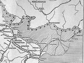
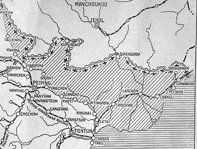
English: The shaded part of this map shows the areas demilitarized by the Tanggu Truce. Note also that the remainder of the Hebei Province, including Beijing and Tianjin, would also be demilitarized of Nationalist forces under the terms of the He-Umezu Agreement, but independent warlords like Song Zheyuan continued to operate there. |
| Час створення | |
| Джерело | a pamphlet called "Sino-Japanese Conflict Elucidated" |
| Автор | Canadian Japanese Association |
Ліцензування
This Canadian work, of which the author or authors are unknown, is in the public domain in Canada because:
(R.S.C., 2020, c. C-42, s. 6.1, R.S.C., 1993, c. C-42, s. 6.1) |
 | |
|
|
Історія файлу
Клацніть на дату/час, щоб переглянути, як тоді виглядав файл.
| Дата/час | Мініатюра | Розмір об'єкта | Користувач | Коментар | |
|---|---|---|---|---|---|
| поточний | 22:47, 18 жовтня 2012 | | 1985 × 1500 (403 КБ) | CurtisNaito | User created page with UploadWizard |
Використання файлу
Така сторінка використовує цей файл:
Глобальне використання файлу
Цей файл використовують такі інші вікі:
- Використання в ar.wikipedia.org
- Використання в en.wikipedia.org
- Використання в es.wikipedia.org
- Використання в fa.wikipedia.org
- Використання в fr.wikipedia.org
- Використання в it.wikipedia.org
- Використання в ko.wikipedia.org
- Використання в lv.wikipedia.org
- Використання в nl.wikipedia.org
- Використання в pt.wikipedia.org
- Використання в ru.wikipedia.org