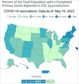
Файл:US map. Percent of total population of all ages by state or territory who completed the COVID-19 vaccination primary series.png

Матеріал з Вікіпедії — вільної енциклопедії.
Перейти до навігації Перейти до пошуку

Повна роздільність(1601 × 1694 пікселів, розмір файлу: 217 КБ, MIME-тип: image/png)

Wikimedia Commons logo Відомості про цей файл містяться на Вікісховищі — централізованому сховищі вільних файлів мультимедіа для використання у проектах Фонду Вікімедіа.

Опис файлу

Опис
English: US map. Percent of total population of all ages by state or territory who completed the COVID-19 vaccination primary series. Hover or click on the states or territories on the map at the CDC source page for more info.

The US territory abbreviations on the map are:

Час створення is the date of the first upload to the Commons. See the file history below for the most recent upload date. Please upload new versions. Use the upload link at the end of the file history list.
Джерело

https://covid.cdc.gov/covid-data-tracker/#vaccinations_vacc-people-booster-percent-pop5 - You may have to bounce around the sidebar and other links to get to the page with these choices: View: People. Show: Completed Primary Series. Population: Total Population. Resulting map will be labeled: "Percent of the Total Population with a Completed Primary Series Reported to CDC by Jurisdictions and Select Federal Entities".

Автор

US Centers for Disease Control and Prevention. After taking a screenshot freeware IrfanView can be used to crop the image, and to add a border: Image menu > add border. Text removed via: Edit menu > Show Paint dialog > Eraser. Text added via: Edit menu > Insert text. For example:

COVID-19 vaccinations. Data as of: May 10, 2023.
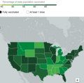
Інші версії File:USA. Percent of people receiving at least one COVID-19 dose reported to the CDC by state or territory for the total population.png

Ліцензування

Public domain
Це зображення є роботою працівника Центру контролю та запобігання хвороб (агентство Міністерства охорони здоров'я і соціальних служб США), зробленою чи сфотографованою ним як частина його обов'язків. Як робота Федерального уряду США, це зображення перебуває в суспільному надбанні в США.

eesti  Deutsch  čeština  español  português  English  français  Nederlands  polski  slovenščina  suomi  македонски  українська  日本語  中文(简体)‎  中文(繁體)‎  العربية  +/−

Підписи

Додайте однорядкове пояснення, що саме репрезентує цей файл
US map. Percent of total population of all ages by state or territory who completed the COVID-19 vaccination primary series.

Об'єкти, показані на цьому файлі

зображує

Історія файлу

Клацніть на дату/час, щоб переглянути, як тоді виглядав файл.

Дата/часМініатюраРозмір об'єктаКористувачКоментар
поточний16:35, 17 травня 2023Мініатюра для версії від 16:35, 17 травня 20231601 × 1694 (217 КБ)TimeshifterLatest map from source.
16:57, 12 грудня 2022Мініатюра для версії від 16:57, 12 грудня 20221226 × 1056 (134 КБ)TimeshifterLatest map from source.
04:18, 13 червня 2022Мініатюра для версії від 04:18, 13 червня 20221240 × 1007 (165 КБ)TimeshifterLatest map from source.
03:19, 27 квітня 2022Мініатюра для версії від 03:19, 27 квітня 20221110 × 996 (144 КБ)TimeshifterLatest map from better source. Better map too.
23:52, 11 квітня 2022Мініатюра для версії від 23:52, 11 квітня 2022749 × 467 (69 КБ)TimeshifterLatest map from source. Map better placed.
23:41, 11 квітня 2022Мініатюра для версії від 23:41, 11 квітня 2022843 × 481 (70 КБ)TimeshifterLatest map from source.
23:39, 11 квітня 2022Мініатюра для версії від 23:39, 11 квітня 20221038 × 1019 (184 КБ)TimeshifterLatest map from source.
15:43, 20 березня 2022Мініатюра для версії від 15:43, 20 березня 20221038 × 627 (98 КБ)TimeshifterUploaded a work by Mayo Clinic from https://www.mayoclinic.org/coronavirus-covid-19/vaccine-tracker with UploadWizard

Така сторінка використовує цей файл:

Глобальне використання файлу

Цей файл використовують такі інші вікі: