Файл:West Germanic dialect continuum in 1900 (according to Wiesinger, Heeringa & König).png

Матеріал з Вікіпедії — вільної енциклопедії.
Перейти до навігації Перейти до пошуку

Повна роздільність(3748 × 3044 пікселів, розмір файлу: 1,31 МБ, MIME-тип: image/png)

Wikimedia Commons logo Відомості про цей файл містяться на Вікісховищі — централізованому сховищі вільних файлів мультимедіа для використання у проектах Фонду Вікімедіа.

Опис файлу

Опис
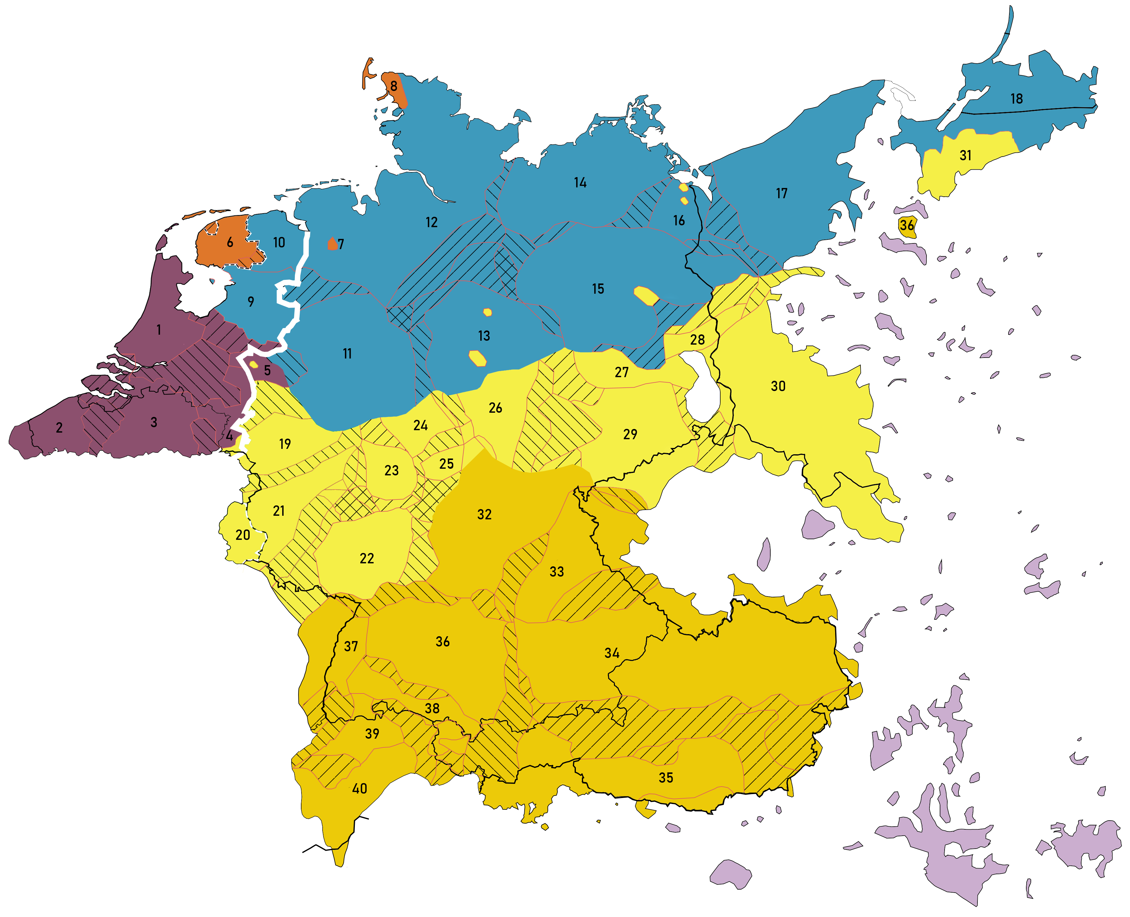
English: A map describing the principal dialect groupings of the closed West Germanic dialect continuum between High German, Low German (in a stricter sense) or Low Saxon, Low Franconian and Frisian around the year 1900. Based on:
  • Peter Wiesinger: Die Einteilung der deutschen Dialekte. In: Dialektologie. Ein Handbuch zur deutschen und allgemeinen Dialektforschung, 2. Halbband, series: HSK 1.2, Berlin & New York, pp. 807–900
  • W. König: dtv-Altas Deutsche Sprache, 2019, Munich, pp. 230.
  • Jan Goossens: Deutsche Dialektologie, Walter de Gruyter, 1977, pp. 48.
  • Wilbert (Jan) Heeringa: Measuring Dialect Pronunciation Differences using Levenshtein Distance, University of Groningen, Groningen, 2004, pp. 232–234 in chapter 9 ([1]). But e.g. omitting Zeelandic and East Flemish from this source.
  • Note: The majority of the map is based on that of Wiesinger, the former eastern areas of the German language are principally based on König. When in conflict in one another, priority was given to Wiesinger.

Legend: Lines

  • The thin white/black dashed line represents the area in which two Dachsprachen are present: Standard Dutch (alongside Standard West Frisian) in the Netherlands, and Luxemburgish (alongside Standard German) in Luxemburg.
  • The thick white line represents Standard Language isogloss (Goossens) between the dialects for which Dutch is the standard language (to the left of the line) and those for whom German is the standard language (right of the line).
  • Striped lines indicate transitional dialects.

Low Franconian varieties: (purple)
1. Central Dutch
2. West Flemish
3. Brabantic
4. Limburgian
5. Kleverlandish or Low Rhenish (in a stricter sense)
Missing:

  • Zeelandic between 1 and 2
  • East Flemish between 2 and 3
  • Southwest Limburgian between 3 and 4
  • Frisian mixed varieties like town Frisian (
    Stad(s)fries
    ), Bildts near 6

Frisian varieties: (orange)
6. West Frisian
7. Saterlandic (last remnant of East Frisian)
8. North Frisian

Low German or Low Saxon varieties: (blue)
9. Overijssels
10. Gronings
11. Westphalian
12. Northern Low German
13. Eastphalian (one yellow part inside is Erzgebirgisch in part of the Harz)
14. Mecklenburg-Pomeranian
15. Brandenburgish (the yellow part inside is Berlinian in Berlin)
16. Middle Pomeranian
17. Eastern Pomeranian
18. Low Prussian
Missing:

  • Stellingwerfs in the middle of 6, 9 and 10

Middle/Central German varieties: (yellow)
19. Ripuarian
20. Luxemburgish (closely related to Moselle Franconian, but different written standard)
21. Moselle Franconian
22. Rhine Franconian
23. Central Hessian
24. Northern Hessian
25. Eastern Hessian
26. Thuringian
27. North Upper Saxon [part of North Upper Saxon–South Markish]
28. South Markisch [part of North Upper Saxon–South Markish]
29. Upper Saxon
30. Silesian
31. High Prussian

Note 1: The empty part near 25, 26, 27 isn't a lake but Sorbian, a Slavic variety.
Note 2: Transylvanian Saxon spoken in Transylvania (Romania) is missing on this map.

Upper German varieties: (ochre)
32. East Franconian
33. North Bavarian
34. Central Bavarian
35. South Bavarian
36. Swabian
37. Low Alemannic
38. Middle Alemannic
39. High Alemannic
40. Highest Alemannic

German language pockets in Eastern and Southern Europe: (lila)

Cp.:

Час створення
Джерело Власна робота
Автор Vlaemink

Ліцензування

Я, власник авторських прав на цей твір, добровільно публікую його на умовах такої ліцензії:
w:uk:Creative Commons
зазначення авторства поширення на тих же умовах
Ви можете вільно:
  • ділитися – копіювати, поширювати і передавати твір
  • модифікувати – переробляти твір
При дотриманні таких умов:
  • зазначення авторства – Ви повинні вказати авторство, надати посилання на ліцензію і вказати, чи якісь зміни було внесено до оригінального твору. Ви можете зробити це в будь-який розсудливий спосіб, але так, щоб він жодним чином не натякав на те, наче ліцензіар підтримує Вас чи Ваш спосіб використання твору.
  • поширення на тих же умовах – Якщо ви змінюєте, перетворюєте або створюєте іншу похідну роботу на основі цього твору, ви можете поширювати отриманий у результаті твір тільки на умовах такої ж або сумісної ліцензії.

Підписи

Додайте однорядкове пояснення, що саме репрезентує цей файл
A map of the closed West Germanic dialect continuum around the year 1900.

Об'єкти, показані на цьому файлі

зображує

Історія файлу

Клацніть на дату/час, щоб переглянути, як тоді виглядав файл.

Дата/часМініатюраРозмір об'єктаКористувачКоментар
поточний13:23, 19 листопада 2021Мініатюра для версії від 13:23, 19 листопада 20213748 × 3044 (1,31 МБ)VlaeminkBildts is closer to Frisian than Hollandic per Heeroma
10:59, 19 листопада 2021Мініатюра для версії від 10:59, 19 листопада 20213748 × 3044 (1,31 МБ)VlaeminkUploaded own work with UploadWizard

Така сторінка використовує цей файл:

Глобальне використання файлу

Цей файл використовують такі інші вікі:

Метадані