Файл:60m artificial fumarole at el tatio geothermal field.jpg

Повна роздільність (900 × 595 пікселів, розмір файлу: 294 КБ, MIME-тип: image/jpeg)
| Відомості про цей файл містяться на Вікісховищі — централізованому сховищі вільних файлів мультимедіа для використання у проектах Фонду Вікімедіа. |
Опис файлу
| Опис |
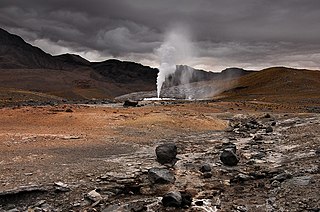
English: In 2008, the “Geortérmica del Norte” consortium - formed by Chilean state owned ENAP and Codelco mining companies in association with Italian Enel Green Power - began exploration in the "quebrada El Zoquete", near the El Tatio geothermal field in Chile's II Region, with the purpose of constructing a 40 MW geothermal plant. After months of exploration, an operating malfunction occurred in well No. 10 in September 2009, causing the eruption of a 60-m-high artificial fumarole which took away virtually all the pressure in the El Tatio complex. Although the company finally managed to close the well, damage was not limited to the visual. Ignorance of both guides and visitors - who were literally running all over the vents - caused extensive damage to the fragile mineral deposits, and the harm make take years, if not decades, to get undone. In fact, an earlier exploration attempt in the late sixties turned into disaster – even if only economically. |
| Час створення | |
| Джерело | Власна робота |
| Автор | Gerard Prins |
| Місцеположення камери | | Перегляньте це та інші зображення поблизу на: OpenStreetMap |
|---|
Altitude: 4334.00 m
Ліцензування
- Ви можете вільно:
- ділитися – копіювати, поширювати і передавати твір
- модифікувати – переробляти твір
- При дотриманні таких умов:
- зазначення авторства – Ви повинні вказати авторство, надати посилання на ліцензію і вказати, чи якісь зміни було внесено до оригінального твору. Ви можете зробити це в будь-який розсудливий спосіб, але так, щоб він жодним чином не натякав на те, наче ліцензіар підтримує Вас чи Ваш спосіб використання твору.
- поширення на тих же умовах – Якщо ви змінюєте, перетворюєте або створюєте іншу похідну роботу на основі цього твору, ви можете поширювати отриманий у результаті твір тільки на умовах такої ж або сумісної ліцензії.

|
Дозволяється копіювати, розповсюджувати та/або модифікувати цей документ на умовах ліцензії GNU FDL версії 1.2 або більш пізньої, виданої Фондом вільного програмного забезпечення, без незмінних розділів, без текстів, які розміщені на першій та останній обкладинці. Копія ліцензії знаходиться у розділі GNU Free Documentation License. |
Історія файлу
Клацніть на дату/час, щоб переглянути, як тоді виглядав файл.
| Дата/час | Мініатюра | Розмір об'єкта | Користувач | Коментар | |
|---|---|---|---|---|---|
| поточний | 07:47, 23 лютого 2010 | | 900 × 595 (294 КБ) | Gerard Prins | {{Information |Description={{en|1=A failed prospecting drill for geothermal exploitation by the “Geortérmica del Norte” consortium, formed by Chilean state owned ENAP and Codelco in association with Italian state owned ENEL, has caused an eco disaste |
Використання файлу
Такі сторінки використовують цей файл:
Глобальне використання файлу
Цей файл використовують такі інші вікі:
- Використання в ba.wikipedia.org
- Використання в en.wikipedia.org
- Використання в en.wikivoyage.org
- Використання в es.wikipedia.org
- Використання в hy.wikipedia.org
- Використання в id.wikipedia.org
- Використання в kk.wikipedia.org
- Використання в ru.wikipedia.org