Файл:Plan Odendaal.png
Перейти до навігації
Перейти до пошуку
Нема версії з більшою роздільністю.
Plan_Odendaal.png (418 × 418 пікселів, розмір файлу: 33 КБ, MIME-тип: image/png)
| Відомості про цей файл містяться на Вікісховищі — централізованому сховищі вільних файлів мультимедіа для використання у проектах Фонду Вікімедіа. |

|
Ця мапа має бути конвертована у векторний формат SVG. Це дає декілька переваг, докладніше про які Ви можете прочитати на сторінці Commons:Media for cleanup. Якщо Вам вже зараз доступна векторна версія даного зображення, завантажте її, будь ласка. Після завантаження замініть цей шаблон на такий: {{vector version available|Назва_завантаженого_файлу.svg}}.
|
Опис файлу
| Опис |
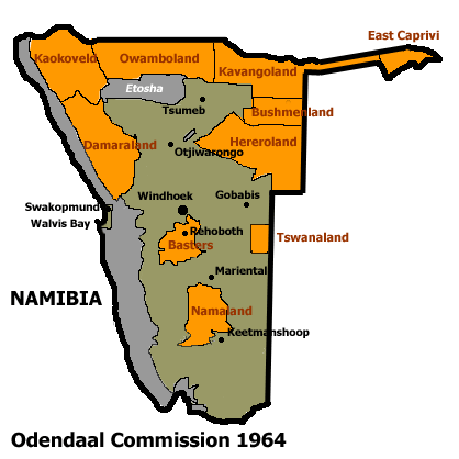
Español: Bantustanes en el territorio de Namibia con Damaraland al noroeste del país
English: This map shows the Odendaal Commission Plan for Namibia of 1964. The plan divided Namibia into Bantustans or Homelands. |
||||||||
| Час створення | |||||||||
| Джерело | |||||||||
| Автор | Bries | ||||||||
| Ліцензія (Повторне використання цього файлу) |
|
||||||||
| Інші версії | French version : Image:Plan_Odendaal-fr.png |

Історія файлу
Клацніть на дату/час, щоб переглянути, як тоді виглядав файл.
| Дата/час | Мініатюра | Розмір об'єкта | Користувач | Коментар | |
|---|---|---|---|---|---|
| поточний | 22:00, 25 листопада 2023 | | 418 × 418 (33 КБ) | LoomCreek | Transparency |
| 07:40, 21 квітня 2005 |  | 418 × 418 (15 КБ) | Bries | This map shows the Odendaal Commission Plan for Namibia of 1964. The plan divided Namibia into ''Bantustans'' or ''Homelands''. I have created the map for the Wikipedia community. Category:Maps of Namibia {{GFDL}} |
Використання файлу
Такі сторінки використовують цей файл:
Глобальне використання файлу
Цей файл використовують такі інші вікі:
- Використання в af.wikipedia.org
- Використання в ar.wikipedia.org
- Використання в ast.wikipedia.org
- Використання в bn.wikipedia.org
- Використання в ca.wikipedia.org
- Bantustan
- Hereros
- Resolució 301 del Consell de Seguretat de les Nacions Unides
- Resolució 309 del Consell de Seguretat de les Nacions Unides
- Resolució 310 del Consell de Seguretat de les Nacions Unides
- Resolució 319 del Consell de Seguretat de les Nacions Unides
- Resolució 323 del Consell de Seguretat de les Nacions Unides
- Resolució 342 del Consell de Seguretat de les Nacions Unides
- Resolució 366 del Consell de Seguretat de les Nacions Unides
- Використання в ckb.wikipedia.org
- Використання в de.wikipedia.org
- Використання в en.wikipedia.org
- South West Africa
- History of Namibia
- Bantustan
- Kaokoland
- Bushmanland (South West Africa)
- Hereroland
- Ovamboland
- Damaraland
- Tswanaland
- Kavangoland
- Rehoboth (homeland)
- Namaland
- East Caprivi
- Fox Odendaal
- Diocese of Namibia
- United Nations Security Council Resolution 301
- Land reform in Namibia
- Aminuis
- Constance Kgosiemang
- Використання в es.wikipedia.org
Переглянути сторінку глобального використання цього файлу.