Файл:Rodrigues Island topographic-zones map-fr.svg
Перейти до навігації
Перейти до пошуку

Розмір цього попереднього перегляду PNG для вихідного SVG-файлу: 637 × 600 пікселів. Інші роздільності: 255 × 240 пікселів | 510 × 480 пікселів | 816 × 768 пікселів | 1088 × 1024 пікселів | 2176 × 2048 пікселів | 1700 × 1600 пікселів.
Повна роздільність (SVG-файл, номінально 1700 × 1600 пікселів, розмір файлу: 989 КБ)
| Відомості про цей файл містяться на Вікісховищі — централізованому сховищі вільних файлів мультимедіа для використання у проектах Фонду Вікімедіа. |

| Опис |
Deutsch: Zonenkarte der Insel Rodrigues
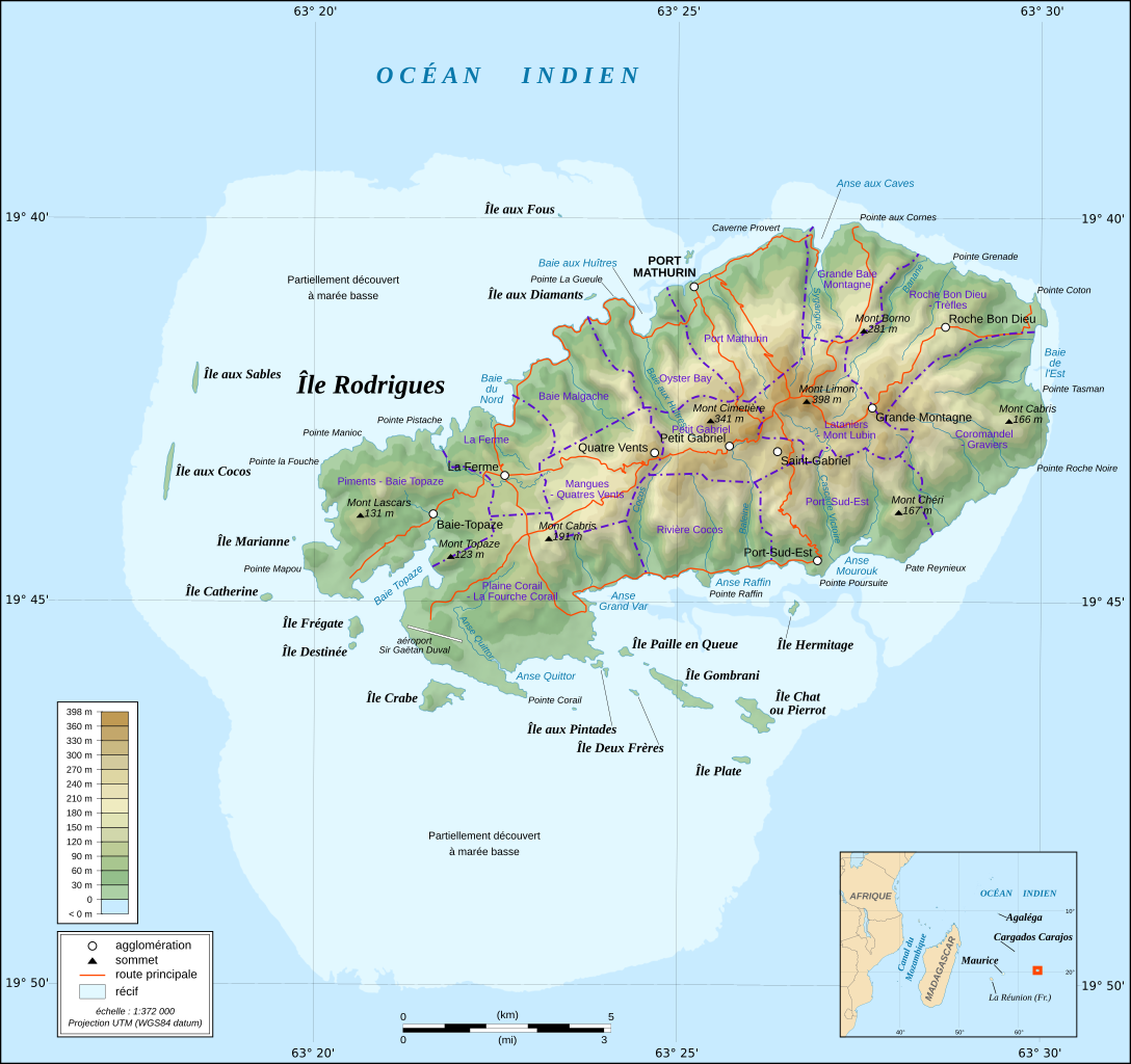
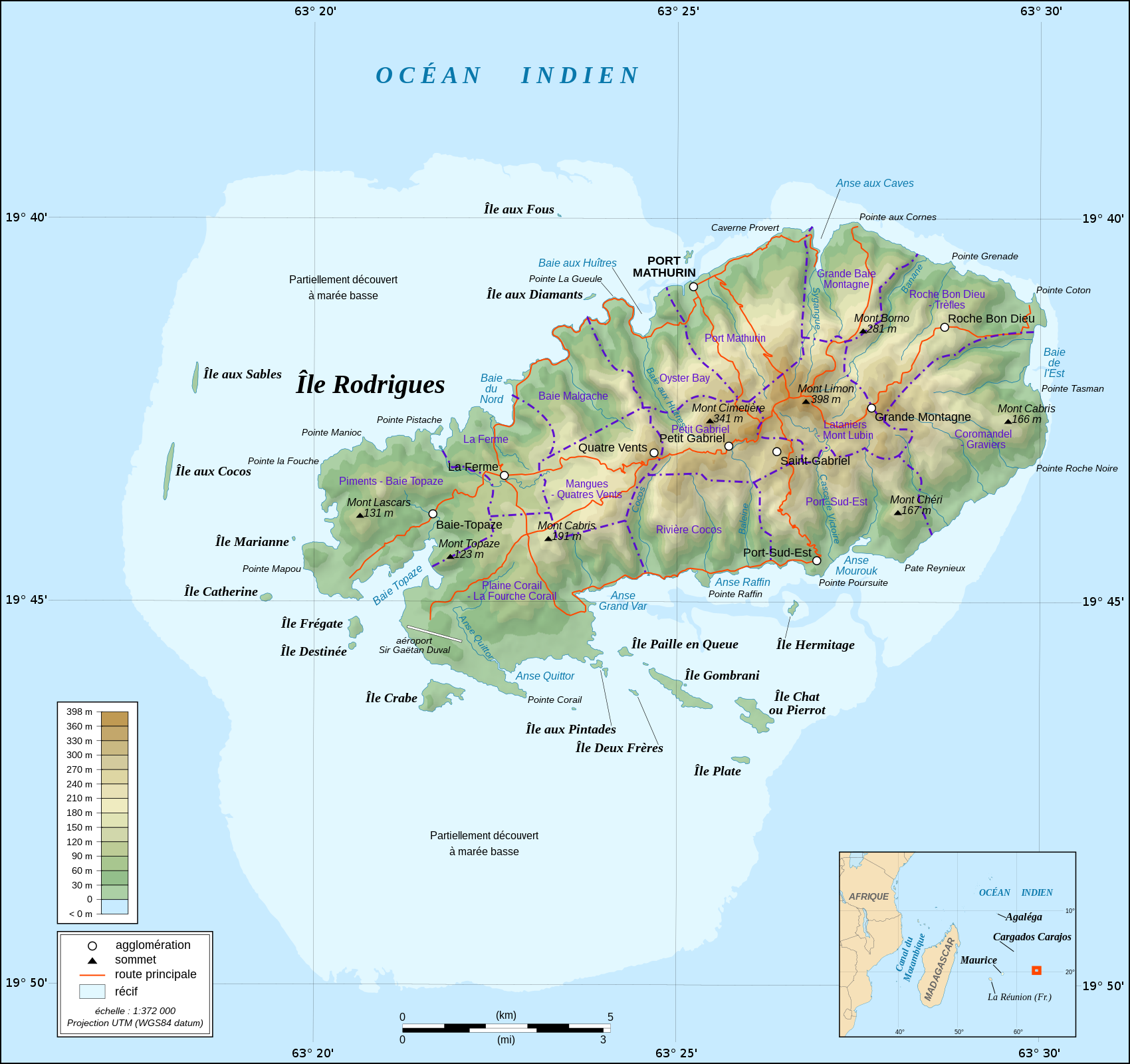
English: Topographic map in French of Rodrigues Island, Mauritius Scale : 1:372,000 (accuracy : about 93 m) ; Printing size : 7.79 x 7.33 cm ; Note : The background map is a raster image embedded in the SVG file. Français : Carte topographique en français de l'île de Rodrigues, Maurice ; UTM projection ; WGS84 datum ; shaded relief (composite image of N-W, W and N lightning positions) ;Échelle : 1:372 000 (précision : environ 93 m) ; Taille d'impression : 7,79 x 7,33 cm ; Note : Le fond de carte est une image bitmap embarquée dans le fichier SVG. Geographic limits of the map: *West : 63° 15' 34.66" E *East : 63° 31' 14.68" E *North : 19° 37' 09.97" S *South : 19° 51' 02.05" S |
| Час створення | (UTC) |
| Джерело | |
| Автор |
|
| Інші версії |
Похідні роботи від цього файлу: |
| Це відредаговане зображення, тобто одержане цифровою обробкою з оригіналу. Зміни: fusion des 2 cartes. Початкове зображення знаходиться тут: Rodrigues Island topographic map-fr.svg. Відредагував M0tty.
|
Цей файл ліцензований на умовах ліцензії Creative Commons Attribution-Share Alike 3.0 Unported
- Ви можете вільно:
- ділитися – копіювати, поширювати і передавати твір
- модифікувати – переробляти твір
- При дотриманні таких умов:
- зазначення авторства – Ви повинні вказати авторство, надати посилання на ліцензію і вказати, чи якісь зміни було внесено до оригінального твору. Ви можете зробити це в будь-який розсудливий спосіб, але так, щоб він жодним чином не натякав на те, наче ліцензіар підтримує Вас чи Ваш спосіб використання твору.
- поширення на тих же умовах – Якщо ви змінюєте, перетворюєте або створюєте іншу похідну роботу на основі цього твору, ви можете поширювати отриманий у результаті твір тільки на умовах такої ж або сумісної ліцензії.
Журнал завантажень локального файлу
This image is a derivative work of the following images:
- File:Rodrigues_Zonenkarte_de.png licensed with Cc-by-sa-3.0
- 2010-03-02T14:15:57Z Vuxi 1284x1209 (562056 Bytes) + Schriftzug
- 2010-03-01T21:56:33Z Vuxi 1284x1209 (558361 Bytes) einige Orte
- 2010-02-27T21:36:06Z Vuxi 1284x1209 (552183 Bytes) + Namen der Zonen + Orte - Berge
- 2010-02-26T10:45:31Z Vuxi 1284x1209 (536481 Bytes) {{Information |Description={{de|1=Zonenkarte der Insel Rodrigues}} |Source={{own}} |Author=[[User:Vuxi|Vuxi]] |Date= |Permission= |other_versions= }} topographic map:[[:File:Rodrigues Island topographic map-de.svg]], borders:
- File:Rodrigues_Island_topographic_map-fr.svg licensed with Cc-by-sa-3.0,2.5,2.0,1.0, GFDL
- 2008-09-06T02:29:37Z Sting 1700x1600 (1025524 Bytes) Adding roads and other labels ; new standard colors
- 2008-05-14T03:46:05Z Sting 1700x1600 (782832 Bytes) == Summary == {{Location|19|43|00|S|63|25|00|E|scale:200000}} {{Information |Description={{en|Topographic map in French of [[:en:Rodrigues (island)|Rodrigues Island]], [[:en:Mauritius|Mauritius]]}} {{fr|Carte topographique e
Uploaded with derivativeFX
Історія файлу
Клацніть на дату/час, щоб переглянути, як тоді виглядав файл.
| Дата/час | Мініатюра | Розмір об'єкта | Користувач | Коментар | |
|---|---|---|---|---|---|
| поточний | 00:36, 25 червня 2022 | | 1700 × 1600 (989 КБ) | Blua lago | File uploaded using svgtranslate tool (https://svgtranslate.toolforge.org/). Added translation for hu. |
| 08:27, 11 серпня 2010 |  | 1700 × 1600 (970 КБ) | M0tty | {{Information |Description={{de|1=Zonenkarte der Insel Rodrigues}} {{en|Topographic map in French of Rodrigues Island, Mauritius<br/>Scale : 1:372,000 (accuracy : about 93 m) ; Printing size : 7.79 x 7.33 cm ;< |
Використання файлу
Така сторінка використовує цей файл:
Глобальне використання файлу
Цей файл використовують такі інші вікі:
- Використання в fr.wikipedia.org
- Використання в nl.wikipedia.org
- Використання в simple.wikipedia.org
- Використання в zh-yue.wikipedia.org