Файл:Switzerland (14399363612).jpg
Повна роздільність (3032 × 1998 пікселів, розмір файлу: 1,53 МБ, MIME-тип: image/jpeg)
| Відомості про цей файл містяться на Вікісховищі — централізованому сховищі вільних файлів мультимедіа для використання у проектах Фонду Вікімедіа. |
.jpg)
Опис файлу
| Опис |
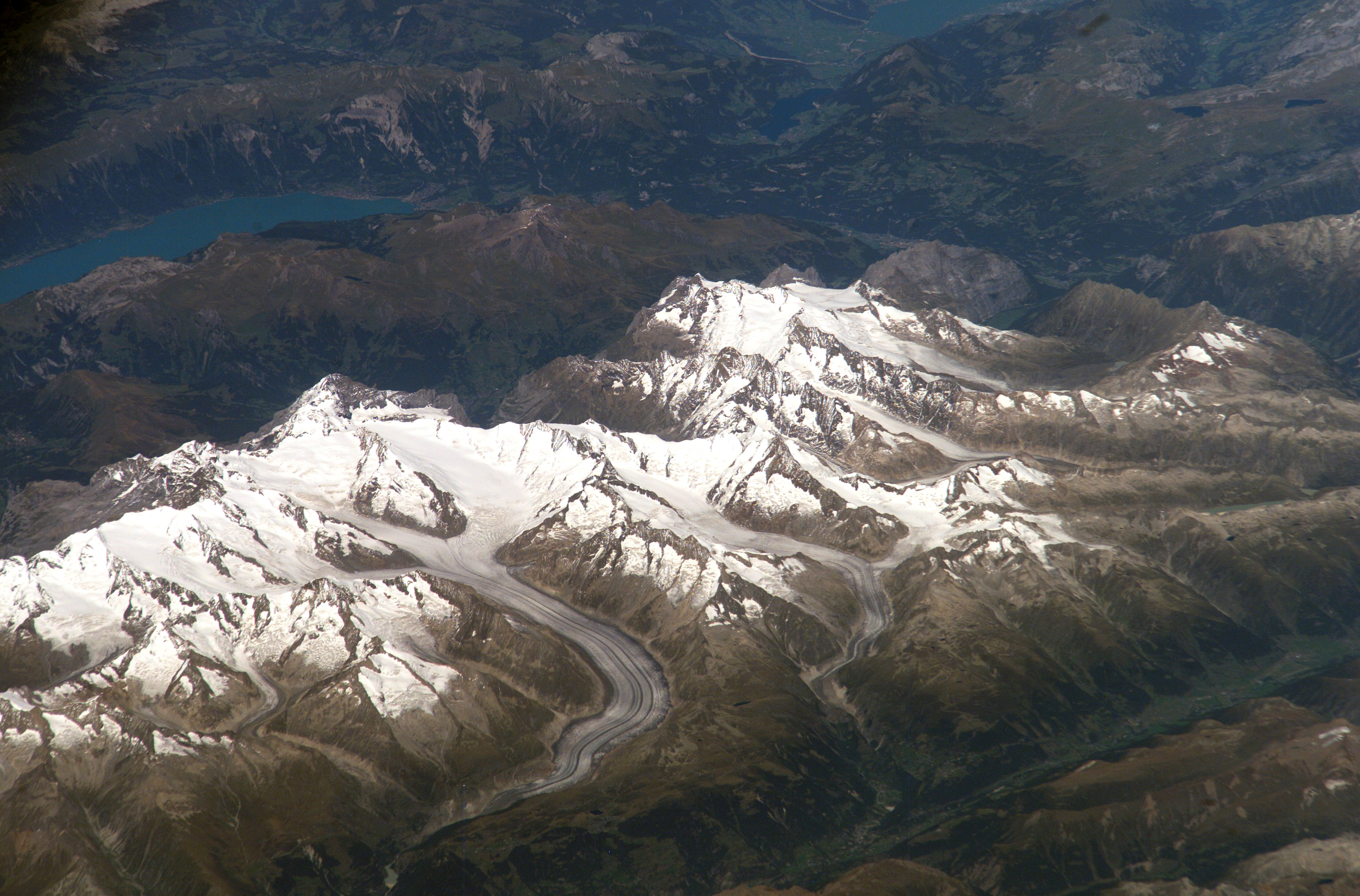
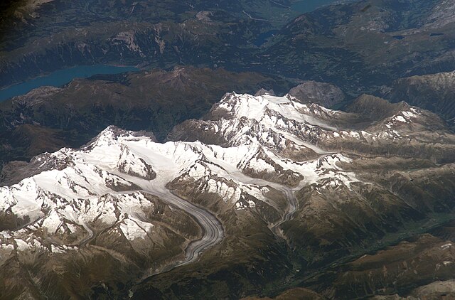
Bernese Alps, Switzerland Bernese Alps, Switzerland is featured in this image photographed by an Expedition 13 crewmember onboard the International Space Station. The formidable mountain system of the Alps stretches across much of central Europe, with seven countries claiming portions of the mountains within their borders (Germany, France, Switzerland, Italy, Liechtenstein, Austria, and Slovenia). The glacial landscape of the Bernese Alps, located in southwestern Switzerland, is well illustrated by this view. The image was taken by a crewmember looking north-northwest while the station was located over the Mediterranean Sea between Corsica and Italy -- this oblique viewing angle imparts a sense of perspective to the image. This type of viewing angle complements more nadir (downward)--viewing imagery of the region. Three of the higher peaks of the central Alps are visible--Jungfrau (4,158 meters), Moench (4,089 meters), and Eiger (3,970 meters). To the east and south of the Jungfrau is the Aletsch Glacier, clearly marked by dark medial moraines extending along the glacier's length parallel to the valley axis. The moraines are formed from rock and soil debris collected along the sides of three mountain glaciers located near the Jungfrau and Moench peaks -- as these flowing ice masses merge to form the Aletsch Glacier, the debris accumulates in the middle of the glacier and is carried along the flow direction. According to geologists, Lake Brienz to the northwest was formed by the actions of both glacial ice and the flowing waters of the Aare and Lutschine rivers, and has a maximum depth of 261 meters. The lake has a particularly fragile ecosystem, as demonstrated by the almost total collapse of the whitefish population in 1999. Possible causes for the collapse, according to the scientists, include increased water turbidity associated with upstream hydropower plant operations, and reduction of phosphorus (a key nutrient for lake algae, a basic element of the local food web) due to water quality concerns. Credit: NASA/ISS NASA Goddard Space Flight Center enables NASA’s mission through four scientific endeavors: Earth Science, Heliophysics, Solar System Exploration, and Astrophysics. Goddard plays a leading role in NASA’s accomplishments by contributing compelling scientific knowledge to advance the Agency’s mission. Follow us on Twitter Like us on Facebook Find us on Instagram |
| Час створення | |
| Джерело | Switzerland |
| Автор | NASA Goddard Space Flight Center from Greenbelt, MD, USA |
Ліцензування
- Ви можете вільно:
- ділитися – копіювати, поширювати і передавати твір
- модифікувати – переробляти твір
- При дотриманні таких умов:
- зазначення авторства – Ви повинні вказати авторство, надати посилання на ліцензію і вказати, чи якісь зміни було внесено до оригінального твору. Ви можете зробити це в будь-який розсудливий спосіб, але так, щоб він жодним чином не натякав на те, наче ліцензіар підтримує Вас чи Ваш спосіб використання твору.
| Це зображення початково було завантажене користувачем NASA Goddard Photo and Video на Flickr за посиланням https://flickr.com/photos/24662369@N07/14399363612. 17 вересня 2016 його переглянув робот FlickreviewR і підтвердив, що зображення ліцензоване згідно з умовами cc-by-2.0. |
| Цей файл перебуває у суспільному надбанні, оскільки він був створений NASA (Національним управлінням з аеронавтики і дослідження космічного простору). Згідно з політикою NASA стосовно авторського права, «матеріали NASA не захищаються авторським правом, якщо не вказано протилежне». (Див. Template:PD-USGov, сторінку політики NASA стосовно авторського права, або політику використання зображень JPL.) | ||
 |
Попередження:
|
Історія файлу
Клацніть на дату/час, щоб переглянути, як тоді виглядав файл.
| Дата/час | Мініатюра | Розмір об'єкта | Користувач | Коментар | |
|---|---|---|---|---|---|
| поточний | 20:33, 17 вересня 2016 | | 3032 × 1998 (1,53 МБ) | Vanished Account Byeznhpyxeuztibuo | Transferred from Flickr via Flickr2Commons |
Використання файлу
Така сторінка використовує цей файл:
Глобальне використання файлу
Цей файл використовують такі інші вікі:
- Використання в ca.wikipedia.org
- Використання в en.wikipedia.org
- Використання в he.wikipedia.org
- Використання в ja.wikipedia.org
- Використання в ko.wikipedia.org
- Використання в ru.wikipedia.org
- Використання в sl.wikipedia.org
- Використання в zh.wikipedia.org
.jpg)