Файл:Kingdom of France 1000.svg
Перейти до навігації
Перейти до пошуку

Розмір цього попереднього перегляду PNG для вихідного SVG-файлу: 485 × 340 пікселів. Інші роздільності: 320 × 224 пікселів | 640 × 449 пікселів | 1024 × 718 пікселів | 1280 × 897 пікселів | 2560 × 1795 пікселів.
Повна роздільність (SVG-файл, номінально 485 × 340 пікселів, розмір файлу: 1,22 МБ)
| Відомості про цей файл містяться на Вікісховищі — централізованому сховищі вільних файлів мультимедіа для використання у проектах Фонду Вікімедіа. |
Опис файлу
Це векторне зображення було створено з допомогою Inkscape .


.svg)
.svg)
.svg)
.svg)
.svg)


.svg)
.svg)
.svg)


.png)
.png)


.svg)


.svg)

.svg)


.svg)
.svg)
.svg)
.svg)


.svg)
.png)


.svg)


.svg)
.svg)


.svg)


.svg)


.svg)
.svg)
.svg)
.svg)
.svg)
.svg)
.svg)
.svg)
_cropped.svg)
.svg)
.svg)
.svg)
.svg)
.svg)
.svg)
.svg)
.svg)
.svg)
.svg)
.svg)
.svg)
.svg)
.svg)
.svg)
.svg)
.svg)
.svg)
.svg)
.svg)
.svg)
.svg)
.svg)
.svg)
.svg)
.svg)
.svg)
.svg)
.svg)
.svg)
.svg)
.svg)
.svg)
.svg)
.svg)
.svg)
.svg)
.svg)
.svg)
.svg)
.svg)
.svg)
.svg)
.svg)
.svg)
Ліцензування
Цей файл ліцензований на умовах Creative Commons Із зазначенням автора - Розповсюдження на тих самих умовах 4.0 Міжнародна
- Ви можете вільно:
- ділитися – копіювати, поширювати і передавати твір
- модифікувати – переробляти твір
- При дотриманні таких умов:
- зазначення авторства – Ви повинні вказати авторство, надати посилання на ліцензію і вказати, чи якісь зміни було внесено до оригінального твору. Ви можете зробити це в будь-який розсудливий спосіб, але так, щоб він жодним чином не натякав на те, наче ліцензіар підтримує Вас чи Ваш спосіб використання твору.
- поширення на тих же умовах – Якщо ви змінюєте, перетворюєте або створюєте іншу похідну роботу на основі цього твору, ви можете поширювати отриманий у результаті твір тільки на умовах такої ж або сумісної ліцензії.
Історія файлу
Клацніть на дату/час, щоб переглянути, як тоді виглядав файл.
| Дата/час | Мініатюра | Розмір об'єкта | Користувач | Коментар | |
|---|---|---|---|---|---|
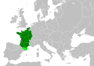
| поточний | 22:55, 19 липня 2023 | | 485 × 340 (1,22 МБ) | DaniCBP | The counties of Barcelona and Aragon were autonomous (de facto independent) and not an integral part of the realm) |
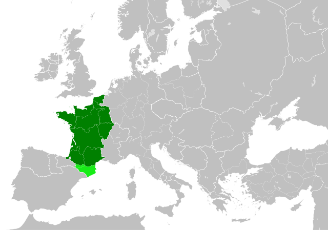
| 16:22, 23 травня 2016 |  | 485 × 340 (1,25 МБ) | Alphathon | Corrected Flanders and incorporated some islands into their respective counties/duchies | |
| 14:41, 23 травня 2016 |  | 485 × 340 (1,25 МБ) | Alphathon | Corrected status of Bohemia | |
| 18:13, 22 травня 2016 |  | 485 × 340 (1,23 МБ) | Alphathon | Split Capua from Benevento and removed both from HRE, along with Spoleto | |
| 16:46, 22 травня 2016 |  | 485 × 340 (1,24 МБ) | Alphathon | == {{int:filedesc}} == {{Inkscape}} {{Information |Description={{en|A map of the en:Kingdom of France within Europe circa 1000 CE. The main subdivisions of the Byzantine Empire, Holy Roman Empire, Burgundy, France and Poland are also shown.}} |So... |
Використання файлу
Така сторінка використовує цей файл:
Глобальне використання файлу
Цей файл використовують такі інші вікі:
- Використання в arz.wikipedia.org
- Використання в cs.wikipedia.org
- Використання в da.wikipedia.org
- Використання в en.wikipedia.org
- Використання в es.wikipedia.org
- Використання в fa.wikipedia.org
- Використання в he.wikipedia.org
- Використання в it.wikipedia.org
- Використання в ko.wikipedia.org
- Використання в mn.wikipedia.org
- Використання в nrm.wikipedia.org
- Використання в simple.wikipedia.org
- Використання в sl.wikipedia.org
- Використання в th.wikipedia.org
- Використання в tr.wikipedia.org
- Використання в ur.wikipedia.org
- Використання в vi.wikipedia.org
- Використання в www.wikidata.org
- Використання в zh.wikipedia.org
.svg)